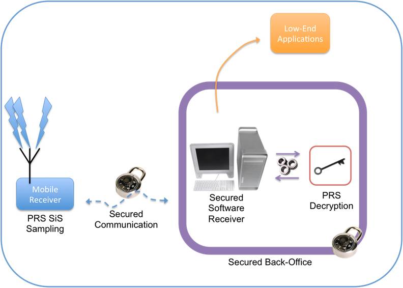
B: Applications Archives - Page 145 of 151 - Inside GNSS - Global Navigation Satellite Systems Engineering, Policy, and Design

B: Applications

March 6, 2008

Astrium-Allsat JV Launches GNSS Reference Network Services across Europe


Astrium Services and Allsat GmbH network+services have created a joint venture, AXIO-NET GmbH, to offer precise navigation and positioning services across Europe.

The companies, which formed a JV in September 2007 to operate the German ascos service, have created a trans-European brand — AXIO-NET  — to extend the service, based on a network of reference stations that generate high-accuracy differential corrections of GPS and GLONASS satellite signals.

Read More >

By Glen Gibbons
February 27, 2008

President’s FY09 Budget Proposes $1.2 Billion for GPS Program

The White House

President Bush’s Fiscal Year 2009 (FY09) budget released earlier this month proposes an allocation of nearly $1.2 billion dollars for GPS operations, according to the Space and Missile Systems Center’s GPS Wing at Los Angeles Air Force Base, California.

If approved, the budget would support continued development of the GPS III satellite program with a first launch in FY14. The somewhat delayed target date appears to match the prediction of the GPS Wing that the first GPS III launch would be set back a few months as a result of Congressional cuts in the FY08 GPS budget.

Read More >

By Glen Gibbons
February 8, 2008

Trimble Breaks Billion-Dollar Mark

As Trimble approaches its 30th anniversary, the company announced that it has passed the billion-dollar mark in annual revenues during 2007.

In a statement of fourth quarter and Fiscal 2007 results released January 29, Trimble reported rvenues of $312.8 million and $1.222 billion, respectively. Net income for fiscal 2007 was up approximately 13 percent, to $117.4 million, compared to net income of $103.7 million in 2006.

Read More >

By Glen Gibbons
[uam_ad id="183541"]
January 25, 2008

Fastrax Launches Two New OEM GPS Units

IT321

Fastrax Ltd. has launched two new GPS OEM receivers, including one with an integrated chip antenna, aimed at designers of mass-market automotive and portable devices.

The Fastrax UC322 incorporates an on-board chip antenna (five millimeters thick) designed to reduce the size from that of typical patch antennas and large separate ground planes, according to the company. Instead, the end device’s printed circuit board functions as part of the antenna.

Read More >

By Glen Gibbons
January 7, 2008

Hope beyond the Hype

A large body of research recognizes personal mobility as the primary future market for global navigation satellite systems in terms of the number of users and potential revenue. This expectation is especially strong for the upcoming European satellite navigation system Galileo, for which location-based service (LBS) applications have a prominent place in market research.

A large body of research recognizes personal mobility as the primary future market for global navigation satellite systems in terms of the number of users and potential revenue. This expectation is especially strong for the upcoming European satellite navigation system Galileo, for which location-based service (LBS) applications have a prominent place in market research.

However, the past decade has seen many GNSS manufacturers and would-be service providers disappointed by the persistent failure of a profitable LBS mass market to emerge and grow rapidly. With the notable exception of a few national markets, particularly in Asia, this failure to thrive has stemmed from a combination of technical, legal, business, and market conditions that have thwarted development of widespread consumer LBS applications.

Previous GNSS activities in the field of LBS have primarily succeeded in commercial and professional applications (such as vehicle tracking and fleet management or remote monitoring of former prisoners out on probation or parole) or for safety and security purposes, such as emergency services. These are applications for which requirements can more easily be pinned down and where revenue streams are easier to estimate and project.

Moreover, regulatory activities and legal mandates have stimulated some large-scale uptake of GNSS technology— such as the U.S. Federal Communications Commission’s E-911 mandate, which requires automatic location identification capability be made available to aid emergency callers using mobile phones.

Despite this slow start, the LBS mass market definitely holds the potential for providing substantial revenue streams. However, its development remains rather difficult to predict. This article will present some of the leading prospective consumer application markets for LBS, examine the leading causes of the still sporadic adoption of LBS in these mass markets, and describe efforts to mitigate the current technical limitations constraining the growth of consumer-driven LBS.

In particular, on this latter point we will consider assisted-GNSS (A-GNSS) technology that uses information — typically, satellite ephemerides and constellation almanac — provided through the communications network infrastructure. We also address the possibility of combining various non-satellite-based positioning technologies with GNSS to provide the quality of service needed to support large-scale development and adoption of LBSs.

. . .

The LBS market has the potential to provide huge benefits to consumers. However, LBS needs to overcome technical and market obstacles before it can achieve the growth rates long predicted by market analyses. The AGILE project seeks to overcome these limitations by defining market drivers for LBS applications and, as detailed in this paper, to mitigate current technical limitations by combining various positioning technologies that can provide the quality of service needed to enable LBS.

(For the rest of this story, please download the complete article using the PDF link above.)

By
January 5, 2008

ACSM-American Congress on Surveying and Mapping Conference

Conference, meeting, and exhibition held jointly with the Land Surveyor’s Association of Washington (LSAW). It will take place at the Spokane Convention Center. A number of GPS-related technical sessions include "The Reality of Real-Time GPS Networks," and "GIS/GPS Inventory Mapping."

Register online at https://www.conferencemanagersforms.com/ACSM/ACSM08Reg.cfm

For more information, contact Colleen Campbell at the number and email below.

Read More >

By Inside GNSS
[uam_ad id="183541"]
January 4, 2008

GLONASS – The Way Ahead

Designers and manufacturers of GNSS products for consumer mass markets may find their next big boost coming from a surprising source — Russia’s GLONASS system.

That was an unmistakable message — and aspiration — expressed by a series of high-ranking Russian governmental officials and representatives of home-grown commercial enterprises speaking at a major GNSS conference in Moscow on April 9 and 10 2007 — the 25th anniversary of the GLONASS program.

With 15 operational GLONASS satellites expected to be broadcasting by the end of April and 18 by the end of the year, Russia is looking to bolster its domestic market for GNSS commercial applications and project its presence into international markets over the next few years. Russian officials are fostering a GLONASS industry association and at least 120 Russian companies were reported to be active in the GNSS sector.

More than 600 delegates registered for the International Satellite Navigation Forum, which featured 87 speakers and three tracks of technical sessions. The event was organized by Profi-T-Centre, a Moscow-based conferencing company, and endorsed by the Russian Federal Space Agency (Roscosmos), the Russian Ministry of Communications and Information, and the Moscow City Government on whose premises the forum took place.

An announcement of a decision to add a CDMA signal to GLONASS that would more closely align the Russian system with GPS and Galileo was not forthcoming at the conference, as many had hoped. Nonetheless, a remarkable number of private companies and public institutes joined the proceedings and discussed their efforts to build and use combined GLONASS and GPS receivers.

Russian President Vladimir Putin has put the restoration of and modernization of GLONASS high on his political agenda and is following its progress closely, a fact underlined by the stature of the officials taking part in the forum: Anatoly Perminov, head of Roscosmos; Yuri Nosenko, Roscosmos deputy chief, head of the GLONASS coordination board, and chairman of the forum’s plenary session; and Lt. Gen. Alexander Kvasnikov, deputy commander of the Russian Space Forces.

They were joined at the opening session by Yuri Urlichich, director general of the Russian Institute of Space Device Engineering (RISDE), which designs the GLONASS space and ground equipment; Nikolai Testoyedov, director general of NPO PM “Reshetnev,” which builds the GLONASS satellites; M. G. Lebedev, a senior advisor to the Russian minister of communications and information; and Sergei Burov, vice-governor of the Yaroslavskaya region near Moscow that has served as a kind of GNSS showcase.

Roscosmos’ Perminov noted, “Development of positioning, navigation, and timing capabilities is one of the top priorities of the Russian Federation, particularly through use of GLONASS as a dual-use system. We have a primary objective of [achieving] compatibility and interoperability with, first, GPS, and, second, Galileo.”

Russia has increased its federal budget allocation for GLONASS to 9.88 billion rubles ($379.7 million) in 2007, more than double the 4.72 billion ruble ($181.4 million) federal expenditure in 2006. Launches of six modernized GLONASS-M spacecraft are scheduled this year — a triple launch in September and another in December.

Despite its international title, the event drew a largely Russian audience, with only a few dozen attendees from outside the country. Nosenko underlined this aspect of the forum, saying, “The primary purpose is to inform a broad Russian audience of satellite navigation and its applications.”

Unlike GNSS conferences in most other venues, the focus was pointedly on Russia’s own GLONASS system. Indeed, although the English translation of the event’s title was “satellite navigation,” the Russian name was “International GLONASS Forum.” (In fact, GLONASS itself is the Russian acronym for Global’naya Navigatsionnaya Sputnikovaya Sistema — or global satellite navigation system.)

Official Imprimatur
Formally enshrined in an April 19, 2006, government directive, Russia’s initiative to develop mass market equipment and applications faces many of the same obstacles to commercialization that GPS has had to overcome during the past 15–20 years and some new challenges as well.

The participation of several high-ranking U.S. officials involved in GPS affairs reflected the growing cooperation in GNSS programs between the two countries: Ken Hodgkins, deputy director of the State Department’s Office of Space & Advanced Technology; Mike Shaw, director of the National Coordination Office for Space-Based Positioning, Navigation, and Timing; and U.S. Air Force Col. Mark Crews, chief engineer at the GPS Wing in the Space & Missile Center, Los Angeles Air Force Base.

“Multiple [GNSS] systems create a winning situation for consumers,” Urlichich said, announcing an initiative to create a GLONASS Forum or what he called “an association of lovers of GLONASS.” By working to make the various systems more compatible and interoperable, Urlichich said, Russia will help lay the foundation for global mass markets. “All together, it will make it possible for mass consumers to have GNSS.”

Russia’s struggle to transform a command economy shaped by more than 70 years of top-down, Communist Party–led governmental planning and direction remains a work in progress. Many of the institutions, terminology, and practices of market-based economies remain unfamiliar to both public officials and nascent businesspeople.
Lebedev, the Communications and Information Ministry advisor, undertook a sort of tutorial on entrepreneurialism and private business in his presentation. “It is necessary,” he told his plenary audience, “to understand the value chain in order to successfully develop markets.”

Lebedev showed several slides from presentations by the Galileo Joint Undertaking and the U.S. Office of Space Commerce to illustrate the GNSS value-added chain and GNSS market projections. Later, he noted that in order to “extract profits in this sector, we need to develop business models.”

Although the level of such discussions might seem basic — even primitive — to Western ears, it does reflect a clear desire to learn how to do business in a completely new way.

Home-Grown GNSS
Perhaps the most notable aspect of the conference emerged in the numerous presentations by domestic Russian companies designing multi-system GNSS receivers and offering GNSS-based services.
Since the dissolution of the Soviet Union, when almost all major manufacturing and business activities were based on government ownership and management, commercial activities have appeared in a variety of forms: privatization of former public enterprises, public/private joint ventures, commercial spin-offs from public institutes, and, increasingly, true private startup companies.

ZAO Navis, for instance, exhibited a variety of GLONASS/GPS products at the forum — mostly larger form factors such ad racks and boards for aviation, commercial vehicle tracking, and synchronizing communications systems.

Adding GLONASS to GPS increases costs by 10–20 percent, according to O. A. Borsuk, chief designer for the 11-year-old Moscow-based design bureau. The company has announced a new GPS/GLONASS module, CH-4706, and plans to bring out a 0.13 micron GPS/Galileo L1 chip in 2008.

Another 13-year-old company, Granit, began developing GPS navigation units in 2001 without government support, E. V. Vikharev, Granit’s deputy director of research, told his forum audience. Characterizing the company’s self-financed progress in post-Soviet Russia as “a difficult experience,” he described four generations of product development, including the current Granit Navigator 04 based on SiRF Technology’s SiRFstarIII.

Vikharev said the company has sold 25,000 units in 15 different models to more than 250 different Russian companies and organizations, including 200 Navigator 02 units installed on city buses in one of Yaroslavl’s projects. Granit has developed a prototype GPS/GLONASS/Galileo and should complete the unit by next year.

RISDE and the St. Petersburg–based Russian Institute for Radionavigation and Time (RIRT), two institutes that have relied on government support for much of their existence, have launched commercial development activities. RISDE’s Urlichich described an agreement signed last month for a “public-private partnership that will develop and produce user equipment.”

S. V. Filantchenkov, deputy chief of RIRT’s research division, traced several generations of GPS/GLONASS receivers developed by the institute since 2004. Known primarily for developing the atomic clocks for GLONASS satellites and ground facilities, RIRT is currently designing a receiver that can process GLONASS M and GPS IIR signals. By next year, Filantchenkov said, the institute’s engineers expect to complete an OEM GPS/GLONASS/Galileo RFIC module that would sell in the $12 range for large volumes.

Telematics services, particularly vehicle tracking/fleet management applications, appear to be the most common GNSS businesses to have developed in Russia so far. The Granit and Navis presentation touched frequently on their telematics products and customers. Other telematics-oriented Russian companies taking part in the forum included M2M, ITS Soft, Geizer, and SecTrack.

A typical business development path for the new enterprises is to secure contracts from public agencies at the federal, state, or local levels to design and install systems. These contracts then establish a foundation for further government contracts and product line extensions.

Lebedev cited “expert opinion” in estimating the current Russian market for GNSS products at up to five million units, primarily in government-regulated commercial and professional markets, including safety and security.

Looking ahead to a true consumer market in Russia, he pointed to two platforms that have incorporated GNSS technology in many other countries: private cars and portable electronic devices. Russia’s automobile market over the next five years is expected to produce sales of two to three million, while 380,000 portable PCs and mobile phones were sold in the country last year.

Although the central government is accumulating large financial reserves from taxes on extraction and exports of natural resources, however, Russia still lacks channels, workplans, and, the experience needed to recycle part of these through the nation’s emerging small and medium enterprises. One promising indication, however, could be found among several representatives of private Russian banks who attended the event to meet with the entrepreneurs and evaluate the prospects for investing in the GNSS businesses.

CDMA: Decision Still to Come
All this GNSS development activity is particularly remarkable considering that GLONASS is a frequency division multiple access (FDMA) system that differs markedly from GPS and Galileo. FDMA is, in fact, the inverse of GPS’s code division multiple access (CDMA) design in which each satellite broadcasts a distinctly coded signal on a common frequency.
In contrast, GLONASS transmits a single code on different frequencies allocated to antipodal sets of GLONASS satellites using two swaths of spectrum — currently from 1598.0625 to 1609.3125 MHz (above GPS L1 centered at 1575.42 MHz) and from 1242.9375 – 1251.6875 MHz for L2 (compared with 1227.6 MHz for GPS L2).

The $64 million question — or, closer to the mark, the $68-billion question (to pick up on Shaw’s projection for the global GNSS market in 2010) — is how compatible the Russians will decide that GLONASS will be. Russia has committed to reaching a decision on the question of adding a CDMA signal by the end of 2007.

Different perspectives and philosophies are competing among the country’s various institutional groups. A new generation of engineers appears inclined to forge greater interoperability with other GNSSes by adding a CDMA signal on a common frequency.

The main arguments raised against CDMA seem to be: single point of failure if all GNSS signals at L1/E1, national security issues, the matter of paying for new civil signal design, and an element of Russian uniqueness.

Numerous GNSS manufacturers — among them JNS, NovAtel, Trimble, Leica, Magellan, and Topcon — already offer combined GPS/GLONASS receivers, typically for professional and commercial activities such as surveying, geodesy, and construction. But such equipment is substantially more complicated in design and expensive — a long way from becoming consumer-friendly.

By having a L1 civil signal apart from the band in which consumers will find most benefit from GPS and Galileo (and, for that matter, China’s Compass GNSS), GLONASS requires manufacturers to widen the reach of their receivers’ antennas and “front-end” components.

As the GPS Wing’s Crews pointed out in his presentation, the key technical issue may be that CDMA-based systems can more easily filter out a common delay in the GNSS time signals on a common frequency. With FDMA systems, he continued, “We can calibrate our filtering for multiple frequencies [and time delays], but it increases costs. That means it’s an issue for making affordable, mass market equipment.”

Nonetheless, the American delegates went out of their way to emphasize that GLONASS signal design questions are completely up to the Russians to sort out.

By
January 3, 2008

Unmanned Air Vehicles

Once we tried to Google “UAV” and got more than two million citations on the Internet.

Try to find the definition of unmanned aerial vehicle (UAV) and you’ll uncover a welter of choices in the literature. So, let’s just say that a UAV is an aerial vehicle capable of sustained flight without the need for a human operator onboard.

Although unmanned aerial vehicles (UAVs) are mostly used in military applications nowadays, the UAVs can also perform such scientific, public safety, and commercial tasks as data and image acquisition of disaster areas, map building, communication relays, search and rescue, traffic surveillance, and so on.

A UAV can be remotely controlled, semi-autonomous, autonomous, or a combination of these, capable of performing as many tasks as you can imagine, including saving your life. Nowadays, UAVs perform a variety of tasks in both military and civil/commercial markets. Indeed, many different types of UAVs exist with different capabilities responding to different user needs.

The purpose of this column is to give the reader an overview of the large number of existing UAV systems and R&D projects as well as the practical challenges facing UAV designers and applications.

. . .

Conclusions

A surprising and seemingly vast number of different types of UAVs exist in the literature, with different capabilities responding to different user needs. We have reviewed the four main categories: MAV/Mini UAVs; Tactical UAVs; Strategic and special task UAVS. MAV/mini UAVs represent the smallest class of UAVs and are mostly used for civil applications. Strategic UAVs are the largest and mostly used in military applications. Although the tactical and strategic UAVs are the more used, in the meantime MAVs and Mini UAVs will become more practical and prevalent.

Different kinds of UAV platforms have different mission and applications. For instance, most research institute prefers rotary wing UAVs with vertical take off and landing capacities as test platforms for demonstrating their research subjects. International competitions such as the Aerial Robotic competition organized by AUVSI are very important, not only as a good way to promote and share research results but also to understand what is going on in the field of UAVs.

As we said before, it is unreasonable to know all the ins and outs of UAVs. That is why one can say: Once we tried to “Google” UAV, we are still Googling UAV,” and . . . we haven’t found the end yet!

(For the rest of this story, please download the complete article using the PDF link above.)

By

China GNSS 101

Late last year, I attended China’s only government-sanctioned international conference on GNSS and visited a number of local companies. I came to one conclusion: The world of GNSS is about to change, and China will have a lot to do with that.

Consider this: China has launched its own GNSS system, Compass/Beidou. It has liberalized policies on GNSS receivers and navigable digital maps. It is already one of the world’s largest economies with enormous capital reserves and steadily-growing disposable income in the hands of millions of citizens.

As a GNSS player, the People’s Republic of China (PRC) arouses interest and concern on at least four levels: as a service provider (compatible or incompatible?), as an equipment manufacturer (competitor or partner?), as a product designer and technology distributor (re-engineering or innovation?), and as an enormous market of largely untapped potential (closed or open?).

In their own fashion, of course, every other GNSS provider brings the same set of questions and, like China, a distinct way of answering them. The real questions are what lessons has China learned from the world’s 30-year experience with GNSS and how will it apply those lessons to the nation’s emerging role of GNSS provider, designer, manufacturer, and marketplace.

One measure of that can be taken from increasingly public, though still carefully scripted statements on the subject from Chinese public officials and industry leaders.

NaviForum: Beidou’s Debut
The Shanghai Navigation Forum (NaviForum) bills itself as the only international GNSS exhibition and conference officially approved by the Chinese government, which is also deeply involved with the organization of the event.

(Sponsors included the Department of High & New Technology Development and Industrialization, Ministry of Science & Technology (MOST); Department of Map Management, State Bureau of Surveying & Mapping (SBSM); and the Science & Technology Commission of the, Shanghai Municipal People’s Government.)

Its fourth annual staging in December 2007 drew more than 700 attendees, with 29 percent coming from outside China, according to conference organizers. And it was, in many respects, a coming out party for Compass, which is also widely known by its Chinese pinyin (alphabetized) name, Beidou.

As with GPS and Russia’s GLONASS systems, Compass began as a military program operated by China’s defense mapping agency and, as with those other two GNSSes, will continue to have a military component. Several geostationary satellites were launched beginning in 2000, broadcasting on a center frequency of 2491.75 MHz in a small slice of spectrum allocated for radiodetermination/mobile satellite.

Until late in 2006, it appeared that Compass/Beidou would remain a regional system, augmenting full-fledged GNSSes. A 2003 agreement committed China to investing €200 million ($290 million) in cooperative development of the European Union’s Galileo system.

In October 2006, however, China announced that it would build a full-fledged GNSS system that would transmit signals in the L1 band where GPS and Galileo military and public safety services are located. Then, last April 14 China launched a middle-earth orbiting (MEO) satellite and quickly began broadcasting signals.

The Compass signals were soon analyzed by researchers at Stanford University and Belgian GNSS receiver manufacturer Septentrio, who published articles in the July/August 2007 issue of Inside GNSS describing their findings.

Subsequently, in a break with a previously restrained public posture on the subject, several representatives from the China Satellite Navigation Engineering Center described the program in some detail at NaviForum 2007. In another session, “New Positioning System,” European and Chinese public and industry panelists focused on Compass. And throughout the conference, Chinese speakers referred repeatedly and favorably to the domestic GNSS system.

Something Old, Something New
Much of the information revealed in the Shanghai meeting merely confirmed what had already been published by outside researchers: L-band signals centered at 1561.098 MHz ± 2.046 MHz (Beidou 1 or B1, overlaying the Galileo E2 band and part of the GPS L1) and 1589.742 MHz (B1-2 on Galileo E1 and the upper portion of GPS L1); 1207.14 MHz ±12 MHz (B2, E5b), and 1268.52 ±12 MHz (B3, on the lower portion of E6).

B1/B1-2 signals would use quadrature phase shift keying (QPSK) and binary offset carrier (BOC) modulations similar to those employed by GPS and Galileo on those frequencies, according to Yang Qiangwen, senior engineer, China Satellite Navigation Project Center (CSNPC, also sometimes referred to as the engineering center) in the Beijing region. The signals will have a pseudorandom noise (PRN) code chipping rate of 2.046 Mcps and a minimum received power level of -163 dBW.

Several of the speakers, however, also provided further insight into Compass and China’s ambitious plans for the system. Ran Chengqi, the CSNPC deputy director speaking in place of the center’s director, Yang Changfeng, told the NaviForum audience that open services would be operated at L1 and L5.

He also emphasized the need for compatibility and interoperability with other GNSS systems, saying, “China will work with the other GNSS providers under UN International Committee on GNSS (ICG) rules.”

“Beidou is a huge investment,” Ran said. “We need to be very careful in its implementation and look at the risks in the market. Our goal is a long-term commitment to users.

He underlined the system’s “strategic role,” adding, “although Beidou has made a fast start, we still need to commit our resources to make sure. We need more open industrial policies,” alluding to the promised publication of a public Interface Control Document (ICD) that would specify Compass’s technical parameters so that receiver manufacturers could build user equipment confidently.

“We have to build up [Compass/Beidou] awareness and our own brand in the world,” Ran concluded. “An open, prosperous, and strong China will develop based on an open, strong, and healthy navigation system.”

In a plenary session speech, Liao Xiao-han, deputy director of High & New Technology Development and Industry, Ministry of Science and Technology (MOST), said, “After completion of Compass, we believe it will be the major supplier of positioning, navigation, and timing [PNT] in China and also a significant supplier of PNT in the world.”

Liao emphasized the need to make Compass “compatible and interoperable with GPS and Galileo” by working to share common frequencies and avoid interference on limited GNSS bandwidth.

Meanwhile, he added, “We are working with Galileo to create synergy,” he said, “We want to expand the PNT footprint.”

According to several speakers, Beidou will be providing a regional service over the east Asia region by 2009 and a global service later at an indeterminate date. Beidou’s open services will be offered without “entrance or authorization fees.”

In the New Positioning System session, Yang reported that the CSNPC would provide an open and free ICD on its website “in the very near future,” admitting, however, that the website was still under development. Compass operators have a “very detailed plan for future beyond 2009,” which would be released along with a launch schedule – also “in the very near future,” he said.

In tests of Beidou’s signals conducted August 21–30, 2007, the CSNPC found an average 0.5 meter residual ranging error and a one-meter sequential error in the MEO satellite’s orbital positions based on comparisons with satellite laser ranging to the satellite. (to see Table 1 and Figure 1, which illustrate this point, download the article pdf above.) The on-board clock error was 5 nanoseconds over 3 hours, and 11 nanoseconds in the course of 24 hours.

Industry on Parade
A well-attended exhibition accompanying the conference drew a couple of dozen Chinese and foreign companies and public agencies. These included the country’s first GNSS company to issue public shares of stock (and the provider of services for the first phase of Beidou), Beijing BDStar Navigation Co., Ltd. Although organizations representing the automotive, portable navigation, and telecom sectors dominated the exhibit, Beijing UniStrong, which plans on entering the U.S. survey market, also was represented.

Underlining the Shanghai region’s generally accepted status as the economic center of China, Chen Kehong, vice-chairman of the Shanghai Municipality’s Science and Technology Commission, described the region’s 14-station differential GPS network.

“In the future, would like to see incorporate multiple [GNSS] systems [into the DGPS network], including Beidou.” Chen said that the regional government would like to see such services based on market rather than planned economy.

“The Shanghai municipal government will move Beidou into the application industry chain,” he added. “We will spare no effort to implement Beidou services and technology development.”

In a corresponding show of bureaucratic support for commercial development, Li Yongxiong, director general of the Department of Map Management, State Bureau of Surveying and Mapping (SBSM), described efforts to liberalize China’s regulatory policies on access to data with which create navigable map databases.

Eleven companies approved by central government to product digital maps with maps currently available from six Chinese companies. These cover every city in China except two, and 95 percent of all of highways, according to Li.

Available mapbases incorporate 5 million points of interest and 1.8 million miles of highways and expressways at 1:10,000 scale. The SBSM is “working very hard on 1:2,000 scale databases in urban areas,” for which the agency would like to create a system to provide real-time updates.

(Articles in future issues of Inside GNSS will return to the subject of China’s domestic GNSS design and manufacturing sector as well as the effect of Compass/Beidou’s development on the world’s other GNSS systems.)

By
January 2, 2008

Geospatial Fusion on the Fly

(The following online version is text only. To see graphs, charts, and images, download the article pdf above.)

The development of GNSS worldwide has fundamentally changed the way many professions conduct their business.

Arguably, the profession of surveying has been most affected because surveyors, at their core, are experts at measurement. For millennia they have been the first to take advantage of any new technology that improves their ability to locate objects accurately.

Until recently, the landmass of Alaska has had little in the way of either control networks or boundary surveys. This is why GNSS has been a godsend for our company, Tanana Chiefs Conference (TCC).

TCC is a nonprofit corporation that primarily consolidates medical and social services for 42 small Alaska Native villages located in remote, mostly roadless regions of the interior. However, we also employ a small group of professional surveyors whose ongoing task is to lay out boundaries for the Alaska Native Claims Settlement Act (ANCSA) village and regional corporations.

These surveys, covering thousands of square miles each summer, are part of a much larger 35-year effort by the United States Bureau of Land Management to delineate government and tribal land claims throughout the state.

In the days before GNSS, an ANCSA project required a major expedition each year to hire surveyors, assemble the equipment and supplies, and mobilize for a survey based in some distant village. It took up to six crews of surveyors and helpers, an office staff of five or six, and a DC-3 full of tripods, total stations, and chainsaws.

Today, 15 years later and with sophisticated GNSS equipment, we get by with a lot less. The results are more accurate and trustworthy, and only a single person is needed to run the surveying office, which consists of a laptop computer.

Villages without Boundaries

Although GNSS has solved many difficulties of large-scale remote surveys, it hasn’t been nearly as helpful at the local level. The villages where our crews are based each field season are scattered over 235,000 square miles — a region slightly smaller than Texas.

These villages generally have a few boundary problems of their own and always a subdivision or two that needs to be surveyed. In remote Alaska, flying in a survey crew is very expensive, and few villages can afford it, so little has gotten done over the years in the way of addressing village boundaries. To be helpful, our company generally donates a week of what we call VTS (village triage surveying) to the various places we visit.

Unfortunately, once we get there, the local work is time consuming because traditional field methods are needed for much of the control and design work. For example, Athabascan villages are communal in nature and rarely contain fences that divide housing and possessions. A good deal of time is needed to locate everything in sight and figure out who owns what. Moreover, original boundary markers are scarce, and hours are spent digging up old axles and snowmobile parts in an effort to uncover the few remaining survey monuments.

It occurred to us that aerial photography might be a worthwhile tool to make our efforts more useful to the locals in the short time we had. For example, if a subdivision could be designed not from a weeklong topographic survey, but from a table-sized, high-resolution orthophotograph, it would save a lot of time and trouble.

Most villages in interior Alaska have been aerially photographed at one time or another, but timely orthophotography is rare, and the resolution of even the best photos — about one pixel per foot — is less accurate than needed. To distinguish the incredible variety of objects scattered throughout a village, something in the range of two to three centimeters per pixel (about half the width of a soda can) would be more useful.

Although new photogrammetric techniques make this high resolution achievable, commissioning new low-altitude photography and the associated expedition – a very expensive undertaking — is not an option for these distant villages.

Off the Shelf Solutions?

We were naïve enough to think that, with a little experimentation, we could achieve these results with off-the-shelf consumer equipment. After all, we had an available helicopter that was used for U.S. Bureau of Land Management (BLM) work, and high-resolution, 10- to 20-megapixel consumer cameras were just now appearing on the marketplace.

It sounded simple enough, why not rectify a series of hi-res, low-altitude digital photos taken from our helicopter?

However, spending a little time investigating this idea only demonstrated how little we knew about photogrammetry. The process wasn’t nearly as easy as we thought. We almost abandoned the idea, but, once again, GNSS saved the day and provided the key to a solution that made everything work.

Digital aerial photography cameras are precise and complex instruments and cost upwards of $500,000. Their large 23×23-centimeter charge-coupled device (CCD) array must be tightly calibrated in conjunction with a fixed camera lens to compute distortion values unique to each camera.

Based on this calibration, software algorithms can then warp each pixel exactly the right amount to remove the lens distortion, which, in turn, allows for pixel matching and the creation of accurate digital terrain models (DTMs) from stereo pairs of georeferenced photos. The calibration repeatability in these cameras is so high that accurate orthophoto mosaics can be assembled using relatively few photo control points on the ground.

A consumer-grade camera, however, even a good one, is not designed for this tight a tolerance. Although such cameras’ lens characteristics can be calibrated, the repeatability is diminished as even a slight change in alignment— say, due to a tiny machining error in a lens bayonet mount — can change the calibration values each time the camera is used.

As important as the camera is the software. Dedicated, full-featured photogrammetric suites are used to rectify digital aerial photos—but these start at a major-league price of $50,000.

Then we came up with a possible alternative.

In recent years relatively inexpensive photo-modeling software has appeared in the marketplace. This software is capable of making accurate 3D models of anything that can be photographed — something as small as a Neolithic human footprint preserved in shale or as large as the ornate façade of a medieval church. It is also commonly used to reconstruct automobile accident scenes, creating 3D computer models for forensic evidence.

In spite of the smaller scale of such subjects, the photo-modeling software shares the same mathematical principles used by dedicated photogrammetry suites. So we explored this idea. Some searching on the World Wide Web led to the discovery of a 3D photo-modeling software used primarily by architects and archeologists.

Although created as companion software to be bundled with an imaging total station, the software can also serve as a stand-alone product that can manipulate any set of controlled stereo pairs — a pair of images containing a minimum number of corresponding photo control points with accurate x, y, and z coordinates. The program is designed to work with tiny, circular photo targets, which can be automatically registered with an order of magnitude greater precision than the human eye.

The technique can produce remarkably accurate results, but, as always, there is no free lunch. To compensate for the looser reliability of lens calibration on small format digital cameras, the software requires a denser network of photo control targets. The total station with which the photo modeling software is usually paired, for example, can populate its digital photos with scores of accurate data measurements for use by the software.

This photo control requirement has relegated photo-modeling software to working in small confined areas. Theoretically, however, it should also work on a larger scale if sufficient photo control is available.

So, it was tempting to think that, with the eight dual-frequency GPS/GLONASS receivers we normally employ in BLM surveys and a few rented four-wheelers, the requisite photo control could be readily established on a village scale. (I imagined survey crews scooting around on ATVs, scattering small aerial targets in their wake like Frisbees, each measured to sub-centimeter accuracy using on-the-fly GNSS!)

Upriver for a Real Test

The Alaska summer is short. We barely had time to fly a test mission with the helicopter and work out altitude, camera settings, and target sizes before we needed to get under way.

Our first real trial took place at Huslia, a village on the Koyukuk River about 10 days by barge from Fairbanks. This river flows from the south flank of the Arctic Divide through broad, glacially carved valleys in the rugged Endicott Mountains of Alaska’s Central Brooks Range.

The Huslia village council had requested a new subdivision survey because about half the residents lived in a still-unsurveyed portion of town. In this congested central village space, subdivision lots must be custom designed using polygonal shapes to conform to each tenant’s use and occupancy. The polygon lots are separated by a chaotic layout of existing roads and trails.

This was exactly the type of situation we had in mind for aerial surveying, but the timing was rather tight. Only a week earlier we had ordered the software from Nick Russill, managing director of TerraDat UK Ltd., a geophysical consulting and contracting company based in Cardiff, Wales. Nick had generously volunteered to help us with the Huslia project because the photo-modeling software has a learning curve, and the giga-pixel, square-kilometer aerial survey would be pushing this modeling software into uncharted territory.

The software package was delayed in transit, however; so, at the last minute Nick changed his travel plans, jumped on a flight to Alaska, and hand-delivered the software.

He arrived by helicopter, intercepting our survey barge, Seloohge, on the Koyukuk River about a day’s voyage below the village. Talk about customer support!

The following morning, as the barge neared Huslia, the crews crowded into the Seloohge’s pilot boat and sped away with a stack of homemade targets that consisted of several dozen 18 inch diameter white vinyl disks packed with beach sand. At the village it didn’t take long to rent a few ATVs from which to scatter the targets, and, by the time we arrived with the big boat, about two hours later, all the requisite photo control was in place.

The targets were roughly distributed in open areas at 80–100-meter spacing throughout the site. As soon as the targets were placed, they were measured to sub-centimeter accuracy using dual baseline, stop-and-go GPS techniques, consuming another one to two hours.

Soon thereafter, Nick and I found ourselves hovering 1,200 feet above the village in a helicopter with the rear door removed. Compared to traditional aerial photography, the technique was definitely low-tech. The camera and stabilizing gyro were suspended from a bungee cord looped around the neck of the photographer, who then leaned out the door, pointed the camera straight down with an outstretched hand, and took photos every second or so as the aircraft slowly flew parallel strips across the village.

Although we soon learned that an onboard guidance system utilizing preprogrammed routes would be more efficient and provide for consistent coverage, this first effort relied entirely on the pilot’s ability to fly parallel routes based on observed ground features, a task more difficult than it sounds. The resolution of the imaging at Huslia topped out at six centimeters per pixel but subsequent improvements in our camera handling techniques improved this to three centimeters per pixel.

The digital camera was then calibrated using a companion program of the photo-modeling software. The program automatically computed the lens distortion parameters by analyzing a series of photographs taken from various angles of a target grid, an E-sized plot of a .dxf image file (included with the software) that we had carefully taped to the galley window of the barge.

Next, choosing 14 photos from our overflight of the village that provided the best overlapping coverage, Nick guided me through the stereo pair registration, measurement of control and tie points, and the creation of a DTM. The process is fairly straightforward once a host of various keyboard shortcuts are mastered.

The software maintains a point data file which can be quickly populated with the adjusted x, y, and z coordinates of the aerial targets. Stereo pairs, selected from a set of two photos that contain roughly 60 percent common overlap, are oriented by the identification of a minimum of four aerial targets visible in both images, plus an additional four to six tie points. Tie points are distinct, uncoordinated points, such as a white food bowl in a dog yard, which can be positively identified on each photograph.

The software automatically matches pixels at a selected tie point and will either accept it or reject it based on the certainty of the match in the corresponding photo. As each pair of tie points are identified, the accuracy of all the points can be examined with a network bundle adjustment routine.

The creation of a digital terrain model, a three-dimensional surface model of the overlapping area contained within the stereo pair, is a little more problematic as it relies on user input to identify breakline positions that are required to assist the software in making accurate pixel matching and elevation determinations.

Breaklines, which are drawn as polylines, are placed where sudden breaks in terrain exist, such as a ditch at the edge of a road or where the ground meets the wall of a house. Photogrammetrists rely on stereo imaging displays for this time-consuming process which manages to be both tedious and frustrating. Fortunately, for those of us using a laptop without a stereo display, the modeling software contains a useful workaround by supplying an auto-correlater that assists the operator with the exact placement of each corresponding polyline vertex.

By late afternoon we had a product: a mosaic of orthophotos held together with cellophane tape that was then proudly displayed on a big table in front of a lively crowd at the village council office. The resolution of the mosaic was such that an observer could easily pick out the smallest objects, and the villagers had no trouble identifying each other’s possessions as we sketched in new lot lines. Visible power poles and overhead wires helped with creation of utility easements.

After dinner, the marked-up photo mosaic was imaged in computer-aided drafting software, and vectors were created to match the layout. Point coordinates were identified for each lot corner position in the subdivision, exported into GPS receivers and, the following day, using real-time kinematic (RTK) techniques our survey crews set the monuments that defined the new subdivision.

The approximate accuracy of the resulting boundary monuments produced 1:50,000 closures, basically the sub-centimeter accuracy one would expect from dual-frequency, differential GNSS measurements. Note that the accuracy of the surveyed monumentation is independent of the accuracy of the aerial photo. In only two days we had accomplished what used to take a week of hard work, and at the same time we created a
very useful product for future land planning in Huslia village.

Low-Cost Accuracy

Of all the things we learned from this experiment, what surprised me the most was the accuracy of the orthophoto. A bundle adjustment of the control and tie points generated error ellipses well within the subpixel range, a fact verified by quality control checks comparing GNSS measured features with corresponding photo locations.

Without doubt it is the dense network of precisely measured control points that allows for this exactness, by constraining the photography like tacks on a board. A field-generated, high-resolution orthophoto of this accuracy could be a powerful new tool for surveyors.

The speed, precision, and reliability of GNSS-measured target networks, combined with the development of high-resolution small-format cameras and well-designed photo modeling software, now makes this possible.

What began as an idea to make pro bono work in the villages more efficient is now opening doors for revenue-generating enterprises such as accurate terrain modeling of mining, development and environmental sites, and low-cost, high-resolution, confined area photo-mapping for projects such as road intersections, construction sites, and siting and layout of resorts.

This is just one example of how the development of GNSS, surveying, and the technology of measurement – and the village of Huslia — have benefited in more ways than had been anticipated.

By
December 10, 2007

China to Reveal Compass Plans ‘Soon’

Liao Xiaohan, Deputy Director-General of High & New Technology Development and Industrialization, MOST

China will release details of its Compass (or Beidou 2) program “soon,” including an Interface Control Document (ICD) for the GNSS system’s open civil service and a launch schedule for additional satellites, according to representatives of the China Satellite Navigation Engineering Center speaking at the Shanghai Navigation Forum (NaviForum) in Shanghai on Thursday and Friday (December 6-7).

Read More >

By Glen Gibbons
IGM_e-news_subscribe