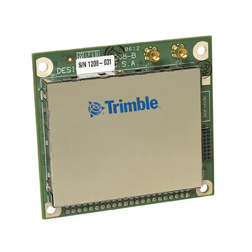
B: Applications

November 17, 2011

GPS Timing Used in Experiment to Measure ‘Faster Than Light’ Particles

No sooner had GPS positioning helped validate key aspects of Einstein’s general theory of relativity in the Gravity Probe-B program than GPS timing has been cited as helping bring his special theory of relativity into doubt.

At issue is the so-called OPERA (Oscillation Project with Emulsion-tRacking Apparatus) experiment, inaugurated in 2006 with the main goal of studying the rare transformation (oscillation) of muon neutrinos into tau neutrinos.

Read More >

By Inside GNSS
November 16, 2011

EU Launches Two Navigation Satellites; Galileo is On Its Way

Europe’s first two Galileo satellites have reached their final operating orbits, opening the way for activating and testing their navigation payloads.

Marking the formal end of their launch and early operations phase (LEOP), on November 3, control of the satellites was passed from the CNES French space agency center in Toulouse to the Galileo Control Center (GCC) in Oberpfaffenhofen, Germany.

Read More >

By Inside GNSS
[uam_ad id="183541"]

Oh No! Not LightSquared Again!

Please.

Please. Please. Please. 

Can we please talk about something besides LightSquared?

Not yet? You mean, they are still here?

And we have so many other GNSS-related topics that deserve comment: 

Some peculiar cuts in civil GPS funds and GPS III budgets being proposed by congressional committees. 

A re-examination — aka analysis of alternatives — of GPS and PNT options in general. Space weather and an impending solar max. Warrantless GPS-aided tracking before the Supreme Court.

Read More >

By Inside GNSS

Network RTK and Reference Station Configuration

Q: What effect does network size have on NRTK positioning?

A: Network real-time kinematic (NRTK) positioning is nowadays a very common practice, not only in academia but also in the professional world. In the last 10 years, several networks of continuous operating reference stations (CORSs) were created to support users. These networks offer real-time services for NRTK positioning, providing centimeter-level positioning accuracy with an average distance of 25–35 kilometers between the reference stations.

Read More >

By Inside GNSS

LightSquared: Who Pays for GPS Receiver Fixes Yet to be Devised?

With more testing on the horizon and a potentially alarming homeland security report about to be released, LightSquared’s efforts to begin work on its proposed wireless broadband service are stuck in the procedural mud.

The delays, which are never good for a commercial company, are piling up just as the firm’s coffers are thinning and need to be replenished with a new round of fund raising.

Read More >

By Dee Ann Divis
[uam_ad id="183541"]

Staying In Lane

Next-generation car navigation may well require the ability to identify the lane in which a vehicle is operating on a motorway. This could support advanced driver assistance in general as well as the observation and study of driver behavior and traffic flow. Such road vehicle applications call for sub-meter positioning accuracy, often in real-time — all this preferably at low-cost.

Read More >

By Inside GNSS

True3D HUD Wins Global SatNav Competition

A San Francisco Bay Area company — Making Virtual Solid–California (MVSC), which snared a trio of awards in a global GNSS competition for its novel approach to driver assistance, is still in early phases of development.

The origins of the company, however, go back more than 40 years to the Cold War era when its principals, Chris Grabowski and Tom Zamojdo, were studying physics and theoretical mathematics at the University of Warsaw, Poland.

But more about that later — first, the news.

Read More >

By Inside GNSS
November 11, 2011

Homeland Security Studies Risks to GPS, Prompts Spoof-Proof Receiver Proposal

Although a Department of Homeland Security (DHS) report on the risks posed by GPS disruptions has yet to be released, the analysis has inspired a proposal to create receivers capable of self-diagnosing spoofing attempts.

“The receiver is the first line of defense,” Logan Scott, president of LS Consulting, told members of the National Space-based Positioning, Navigation, and Timing (PNT) Advisory Board this week.

Read More >

By Inside GNSS
November 8, 2011

GPS Coalition To FCC: LightSquared Must Not Use Upper 10-MHz Band

[Update November 9 2011] In an ex parte filing with the Federal Communications Commission (FCC) on November 8, a leading GPS advocacy group has asked that the agency “promptly rule” that LightSquared not be permitted to pursue high-powered terrestrial operations in the upper Mobile Satellite Services (MSS) band adjacent to the GPS L1 band.

Read More >

By Inside GNSS
IGM_e-news_subscribe