Environment Archives - Page 9 of 14 - Inside GNSS - Global Navigation Satellite Systems Engineering, Policy, and Design

Environment

January 9, 2014

Baška GNSS Conference 2014

The 8th annual conference on the Croatian Adriatic aims at GNSS experts and and focuses on GNSS resilience and GNSS applications development. It will take place at Baška on the resort island of Krk in Croatia from May 7 to May 9, 2014.

The deadline for abstracts is March 1, 2014.

Topics include:

  • core satellite navigation systems’ developments and modernisation,
  • satellite-based augmentation systems (SBAS),
  • space weather and ionospheric effects on GNSS performance and operation,
  • GNSS applications for air, marine, land and personal navigation, Location-Based Services, Intelligent Transport Systems, and Search and Rescue (SaR) operations,
  • resilience development againts natural (space weather and ionospheric) and artificial (jamming, spoofing and meaconing) disruptions of GNSS services
  • statistical and digital signal processing for electronic navigation and weak signal detection,
  • GNSS receiver design (including Software-Defined and Cognitive Radio),
  • GNSS education and professional advancement,
  • advanced multidisciplinary GNSS applications (in geomatics, transport, predictive analytics, remote sensing, agriculture, geodesy, forestry, tourism, environment protection, meteorology and science),
  • GNSS advancements, parallels and alternatives,
  • regulatory and legal aspects of GNSS utilisation,
  • Special session: space weather effects on GNSS performance and operation
  • Special session: statistical signal processing and Bayesian estimation for satellite navigation, and
  • Special session: Intelligent Transport Systems (ITS)

The Royal Institute of Navigation, London, UK, Faculty of Maritime Studies, University of Rijeka, Croatia and Faculty of Transport and Traffic Sciences, University of Zagreb, Croatia, and is technically co-sponsored by Beihang University of Aeronautics and Astronautics, Beijing, China.

For more information, contact Ms. Sally-Anne Cooke, the RIN conference and events manager at conference@rin.org.uk

By Inside GNSS
January 1, 2014

GAO Faults DHS, DoT for GPS Interference/Backup Effort

Federal efforts to protect positioning, navigation and timing (PNT) signals came under sharp criticism during the December meeting of the National Space-Based Positioning, Navigation, and Timing (PNT) Advisory Board, with the Department of Homeland Security (DHS) getting a bureaucratic ear boxing for having done little so far to specifically protect GPS.

Read More >

By Inside GNSS
[uam_ad id="183541"]
August 30, 2013

Predator UAV Provides Surveillance in Battle Against Yosemite Fire

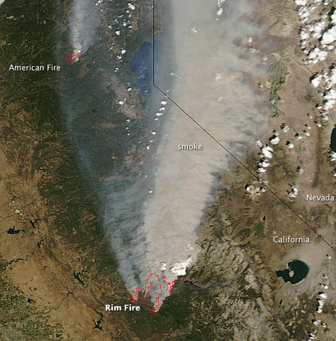
NASA satellite photo shows northward drift of smoke from wildfires near Yosemite National Park.

Better known for supporting U.S. troops in firefights in Afghanistan firefights, a Predator drone has been deployed to help California National Guard firefighters battle wildfires raging around Yosemite National Park.

U.S. Department of Defense Secretary Chuck Hagel approved the use of a GPS-guided MQ-1 Predator to support firefighters battling the Rim Fire that has expanded to more than 160,000 acres, accordeing to Air Force Lt. Col. Thomas Keegan, California National Guard public affairs officer.

Read More >

By Inside GNSS
August 2, 2013

QinetiQ, Nottingham Scientific Demonstrate Cloud-Based Galileo PRS Technology

Two British companies, QinetiQ and Nottingham Scientific Ltd (NSL), have partnered to demonstrate an Internet “cloud”-based technology that enables a wide range of high-volume, low-cost satellite navigation applications using Galileo’s Public Regulated Service (PRS).

The NSL-QinetiQ application allows a service provider to host secure navigation on one server in a back office, capture data from multiple locations and units, and subsequently verify the location of a remote user.

Read More >

By Inside GNSS
July 31, 2013

Exit Interview: GPS Directorate’s Col. Bernie Gruber

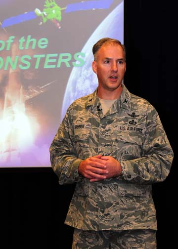
USAF Col. Bernie Gruber, GPS Directorate. Air Force photo

Last month, USAF Col. Bernard Gruber stepped down after three years of running the Global Positioning Systems Directorate at Los Angeles Air Force Base.

The GPS Directorate, originally established in 1974 as the NAVSTAR GPS Joint Program Office, is responsible for development, acquisition, fielding and sustainment of all GPS space segments: the modernized operational control segment (OCX), the next-generation GPS III satellites, and modernized GPS user equipment (MGUE).

Read More >

By Inside GNSS
[uam_ad id="183541"]
June 28, 2013

Homeland Security’s National Risk Estimate on GPS Disruption: Still a Lot of Unknowns

The U.S. Department of Homeland Security has released an abbreviated fact sheet and a summary report on its evaluation of the risks to U.S. critical infrastructure from GPS disruptions.

The unsurprising “bottom line,” as the public summary put it: “U.S. critical infrastructure sectors are increasingly at risk from a growing dependency on GPS for positioning, navigation, and timing (PNT) services. Such dependencies are not always apparent.”

Read More >

By Inside GNSS
June 18, 2013

EU Calls Out European Industry on GNSS Opportunities

Gian Gherardo Calini. GSA photo

According to European Union (EU) figures, there should be €90 billion in benefits to be reaped by industry as a result of Europe’s €11 billion investment in Galileo. But what that really means is that there will be €90 billion in new income out there for someone to take.

Read More >

By Inside GNSS
May 28, 2013

Di Qiu: Opportunities of Signals

Di Qiu at the site of her current employer

SIDEBAR: Di Qiu’s Compass Points

Landing all-weather aircraft safely in storms. Protecting sensitive data not only through encryption but based on the location at which it is being accessed. Ensuring that accurate and timely information reaches first responders responding to emergencies. 

Although still in the early part of her career, Di Qiu has already made significant contributions to these crucial applications of navigation technology. 

Read More >

By Inside GNSS
May 20, 2013

GENIUS Workshop: Vulnerabilities of GNSS

The October entry in this EU-sponsored series of free GNSS training workshops concerns GNSS vulnerability. It will take place at the University of Nottingham on October 8, 9 and 10.

The instructors will be Terry Moore, Alan Dodson and Marcio Aquino, all faculty at University of Nottingham Geospatial Institute.

The topics:

GNSS Overview: Position fixing, dead reckoning, space segment and SV blocks, ground control and improvement programs,user segment and applications

Read More >

By Inside GNSS
May 13, 2013

White House Moves to Harden Infrastructure against GPS Disruption

System engineers across the country may soon be planning, in some cases perhaps for the first time, what they would do if they could not use the GPS service.

The effort is part of an expanded White House initiative to protect the nation’s critical infrastructure. Alhough infrastructure protection programs have been under way for some time, they did not necessarily address GPS vulnerabilities explicitly.

Read More >

By Inside GNSS
May 2, 2013

MUSTER

Existing methods for improving the GNSS performance commonly attempt to enhance the signal processing and navigation estimation parts of a single receiver. Such approaches, however, leave unexplored the potential benefits inherent to the integration of data from multiple receivers.

Read More >

By Inside GNSS
1 7 8 9 10 11 14
IGM_e-news_subscribe