
December 2, 2016
U.S. Transportation Department Starts Hunt for GPS Timing Backup Supplier
Federal officials are finally moving on a year-old, two-phase plan to establish a long delayed backup for the GPS system.
By Inside GNSSGlobal Navigation Satellite Systems Engineering, Policy, and Design
Federal officials are finally moving on a year-old, two-phase plan to establish a long delayed backup for the GPS system.
By Inside GNSS The Air Force’s Global Positioning Systems Directorate contracted the CUP2 upgrade.
Lockheed Martin has announced a major upgrade to modernize the GPS ground control system, the company said. The commercial-off-the-shelf (COTS) upgrade no. 2 (CUP2) project, which became operational in mid-October to manage the 31 GPS satellites, is the latest step in the U.S. Air Force’s plan to refresh technology and transform the legacy operational control segment, also known as the Architecture Evolution Plan (AEP), the company said.
By Inside GNSS
Government watchdogs said in a new report that schedule slippages in the new GPS ground system — which in October had another four months added to its repeatedly extended schedule — are more of a factor in delays to GPS modernization than technical problems with the satellite’s payload.
By Dee Ann Divis
The navigation sensors for location-based services (LBS) are complex technical systems. Modern technical science can answer most questions about the optimality of particular position determination methods, signal processing algorithms, electronic circuits or similar well-defined problems, but the rigorous answer to the questions concerning the optimal LBS positioning sensor are still a big problem.
By Inside GNSS
 One of 12 magnetograms recorded at Greenwich Observatory during the Great Geomagnetic Storm of 1859
 1996 soccer game in the Midwest, (Rick Dikeman image)
 Nouméa ground station after the flood
 A pencil and a coffee cup show the size of NASA’s teeny tiny PhoneSat
 Bonus Hotspot: Naro Tartaruga AUV
 Pacific lamprey spawning (photo by Jeremy Monroe, Fresh Waters Illustrated)
 “Return of the Bucentaurn to the Molo on Ascension Day”, by (Giovanni Antonio Canal) Canaletto
 The U.S. Naval Observatory Alternate Master Clock at 2nd Space Operations Squadron, Schriever AFB in Colorado. This photo was taken in January, 2006 during the addition of a leap second. The USNO master clocks control GPS timing. They are accurate to within one second every 20 million years (Satellites are so picky! Humans, on the other hand, just want to know if we’re too late for lunch) USAF photo by A1C Jason Ridder.
  Detail of Compass/ BeiDou2 system diagram
 Hotspot 6: Beluga A300 600ST

Highest altitude fix for a GPS signal, GNSS timing signals and hacking the Grid, Eagles act as drone countermeasures and rumors of a GNSS-nano-chip contributes to cash crisis in India
By Inside GNSSAmerican Election 2016 — now that was something, wasn’t it?
A national unpopularity contest. Sort of Commedia dell’arte meets Monty Python, directed by Todd Phillips, with a cameo appearance by Berlusconi.
Did we find it risible? Oh, yes, but were those tears of laughter, sorrow, or disbelief?
So, while we are collectively unpacking the meaning and nonsense from two years of political theater and telling each other our fortunes for the next four, what does it portend for GNSS?
Well, the tea leaves are a little unclear.
By Dee Ann Divis
With the Republican Party now entirely in charge of Washington’s prime policy real estate the neighborhood is going to change. The current residents are warily watching the newcomers take measurements for a major remodel of agencies, lobbying rules, national priorities, and international relationships, and everyone is assessing the implications of the new landscape.
By Dee Ann Divis Trimble GSC900 Allows Precision Excavation
Trimble has announced that the Hitachi Construction Machinery’s ZX200X-5B semi-automatic excavator is now available in Japan with the GCS900 Grade Control System.
The system uses GNSS, laser, sonic, or total station technology, to position the heavy machinery’s blade or bucket in real-time, for significant reduction in material overages and improving the contractor’s productivity, the company said. The unit makes design surfaces, grades, and alignments accessible to the operator inside a cab, Trimble said.
By Inside GNSS
GPS seems to have come out of nowhere. There was no progression like eight-track tape to cassette to CD to MP3 player. One day we were driving around clueless of where we were, struggling with roadmaps bought as gas stations that couldn’t be folded back neatly once opened and — suddenly — there was an amiable female voice coming out of the dashboard offering directions to our destination and showing no signs of impatience when we made wrong turns.
From the author’s introduction to GPS for Everyone
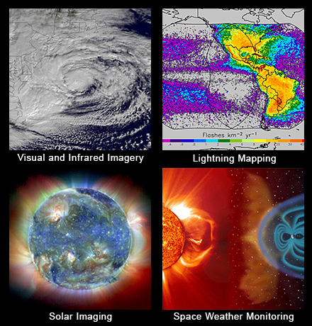 GOES-R primary capabilities. NOAA image
A United Launch Alliance (ULA) Atlas V rocket carrying the Geostationary Operational Environmental Satellite R-series (GOES-R) for National Aeronautics and Space Administration (NASA) and National Oceanic Atmospheric Administration (NOAA) lifted off from Cape Canaveral Air Force Station, Florida, yesterday (November 19, 2016) headed for geosynchronous orbit.
By Inside GNSS
Calgary, Canada-based NovAtel Inc. announced that the Canadian Army has successfully tested its GPS Anti-Jam Technology (GAJT) in live-fire conditions on the M777C1 howitzer.
GAJT protects GPS-based navigation and precise timing receivers from intentional jamming and accidental interference, Novatel said. The unit features a null-forming antenna system, which ensure satellite signals necessary to compute position and time are always available, the company said.
By Inside GNSS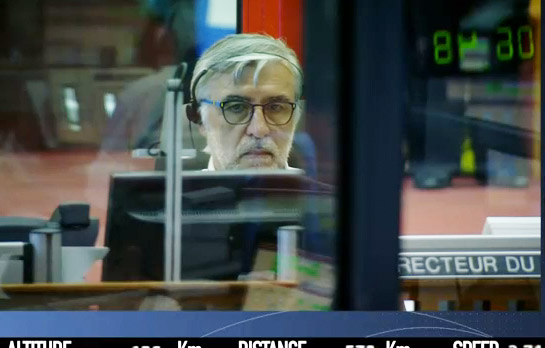 Didier Faivre, director of the Guiana Space Center, overseeing launch of four Galileo satellites. Screen capture of launch video by European Space Agency/ArianeSpace.
A modified Ariane 5 rocket lifted four Galileo satellites into orbit today (November 17, 2016) following an 8:06 a.m. (EST) launch from the European Space Center in Kourou, French Guiana.
The Galileo satellites reached their target altitude, after a "flawless release" from the new dispenser designed to handle four satellites, according to the European Space Agency (ESA). The dispenser released the first pair three hours and 25 minutes after liftoff, while the second separated 20 minutes later.
By Inside GNSS
The European Commission (EC) has opened the third round of competition for €33 million (US$35.15 million) in Horizon 2020 (H2020) contracts for development of European GNSS (EGNSS) applications exploiting use of Galileo and the European Geostationary Navigation Overlay Service (EGNOS).
By Inside GNSS