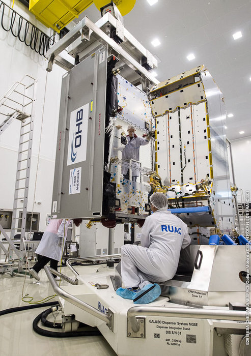
A: System Categories

ION Southern California Section December Meeting

Torrance, CA

The Southern California Section of the Institute of Navigation’s December meeting will take place at the John Deere facility in Torrance, CA on December 15, 2015.

Dr. Chun Yang will speak at the meeting.  The title of the talk is Sharpening Peak Performance of GPS Signals. In this talk, the variable IF tracking architecture that improves the
peak performance will be presented together with possible implementation
schemes. Simulation results will be used for illustration and analysis.

Read More >

By Inside GNSS
December 8, 2015

New Beijing Airport Extends Trimble Integrated Construction Contract

Concept design for the world’s largest airport passenger terminal – the Beijing New Airport Terminal Building. Zaha Hadid Architects drawing

Trimble announced today (December 8, 2015) that it has received a contract extension to use the company’s technology from Trimble to integrate construction and operations for the high-profile Beijing New Airport Project, expected to be the world’s largest when completed at an estimated cost of $13.1 billion.

In April, Trimble won the initial bid to supply the project with a construction information management system. Based on the success of the solution to date, the contract has been extended to include additional machine control systems for soil stabilization.

Read More >

By Inside GNSS
[uam_ad id="183541"]
December 2, 2015

Two New Galileo Satellites Enter Service

Another pair of Galileo satellites is now fully operational, broadcasting navigation signals and, since Tuesday (December 1, 2015), transmitting search and rescue messages worldwide.

Galileos 7 and 8 were launched from Europe’s Spaceport in French Guiana on March 27. Their navigation payloads underwent a lengthy test campaign confirming their performance and integration into the worldwide Galileo ground network.

Read More >

By Inside GNSS
November 30, 2015

Broad Support for GNSS-Based Transportation Tech in New Highway Bill

The House and Senate, now working with a fresh extension, have until December 4 to hammer out the details of a new highway bill. The legislation will authorize — but not necessarily appropriate — Highway Fund monies for state roadways for as long as six years and likely spin up research into intelligent transportation systems (ITS) and connected and autonomous vehicle technology — three sectors that rely on GNSS for success.

Read More >

By Inside GNSS

Cryptic DHS Reorganization Plan Omits Mention of Protecting GPS

The Department of Homeland Security (DHS) is reorganizing the vast directorate responsible for cybersecurity and the nation’s critical infrastructure. Thus far, however, protecting the GPS signals essential to most of that infrastructure hasn’t rated a public mention in the plans.

The reorganization of the National Protection and Programs Directorate (NPPD) got underway in July, the month after the Office of Personnel Management revealed a computer beach that left the fingerprints and personal information of 5.6 million federal employees in the hands of hackers.

Read More >

By Inside GNSS

GNSS Hotspots | November 2015

One of 12 magnetograms recorded at Greenwich Observatory during the Great Geomagnetic Storm of 1859
1996 soccer game in the Midwest, (Rick Dikeman image)
Nouméa ground station after the flood
A pencil and a coffee cup show the size of NASA’s teeny tiny PhoneSat
Bonus Hotspot: Naro Tartaruga AUV
Pacific lamprey spawning (photo by Jeremy Monroe, Fresh Waters Illustrated)
“Return of the Bucentaurn to the Molo on Ascension Day”, by (Giovanni Antonio Canal) Canaletto
The U.S. Naval Observatory Alternate Master Clock at 2nd Space Operations Squadron, Schriever AFB in Colorado. This photo was taken in January, 2006 during the addition of a leap second. The USNO master clocks control GPS timing. They are accurate to within one second every 20 million years (Satellites are so picky! Humans, on the other hand, just want to know if we’re too late for lunch) USAF photo by A1C Jason Ridder.
Detail of Compass/ BeiDou2 system diagram
Hotspot 6: Beluga A300 600ST

1. DÉJÀ VU
Annapolis, Maryland and Kings Point, New York USA

Read More >

By Inside GNSS
[uam_ad id="183541"]
November 29, 2015

Failure to Communicate

For an organization with its name, the Federal Communications Commission (FCC) is a remarkably opaque public entity. 

Such is the case with the agency’s inaction on requests by foreign GNSS services to waive the so-called FCC Part 25 rules that require licensing of non-Federal receive-only Earth stations (e.g., GNSS receivers) operating with non-U.S. licensed space stations (i.e., satellites). 

Although at least one such request has reportedly been submitted, the FCC has not even acknowledged it, let alone moved to render a decision on the request. 

Read More >

By Inside GNSS

eCall

Figures 1 & 2

On April 28, 2015, the European Parliament voted in favor of an eCall regulation, which requires all new models of passenger cars and light vans that will be certified for the European market to be equipped with the automated emergency-call technology beginning in April 2018. The measure applies to all such vehicles regardless of selling price. In the future, a similar service may be implemented for trucks as well.

Read More >

By Inside GNSS
November 17, 2015

International Navigation Gathering Highlights GNSS Advances and Distractions

Sergey Revnivykh

Speakers at the recent International Association of Institutes of Navigation (IAIN) conference in Prague threw into stark relief some of the big GNSS programs and even bigger GNSS questions.
 
Prof.-Dr. Günter Hein, former head of the European Space Agency (ESA) EGNOS and GNSS Evolution Program Department and Emeritus of Excellence at University FAF Munich, delivered a fact-filled and level-headed presentation on the status of Galileo, the European Union’s civil-owned and non-military GNSS, with slides and information provided by ESA.
 

Read More >

By Inside GNSS
IGM_e-news_subscribe