NTS-3 Satellite Prepares for Launch to Experiment with Ways to Improve GPS.
Nearly 50 years ago, there were no smart phones, no GPS-guided weapons, no turn-by-turn direction systems in automobiles.
That’s when the U.S. Air Force launched the first two Navigation Technology Satellites, NTS-1 and NTS-2, to expand and improve the nascent positioning capability provided by GPS forerunner programs such as Transit and Timation. NTS-1, launched in 1974, and NTS-2, launched in 1977, weren’t part of the original GPS constellation but were instead orbiting testbeds for various technology systems such as clocks and solar cells.
Since 1977 and today, of course, satellite positioning has become an integral part of everyday life, and certainly an integral part of military operations. This was amply demonstrated in Ukraine, when an attack with an unmanned surface vessel on Russian targets failed because of a lack of satellite connectivity. It’s a technology that’s increasingly on every vehicle and in every pocket.
After this multi-decade burst of positioning activity, the U.S. Air Force is preparing to launch the third in the NTS series, NTS-3, next year, after several years of launch delays. Like its predecessors, it’s aimed to improve the GPS system. According to the Air Force Laboratory (AFLR), “it will push the boundary of today’s space-based position, navigation and timing technology to pave the way for a more robust, resilient and responsive architecture for satellite navigation technology.”
From the Beginning
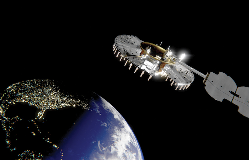
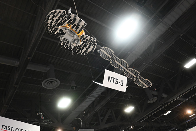
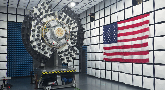
The NTS-3 space vehicle was designed, developed, integrated and tested by prime contractor L3Harris. The company displayed a suspended model of the space vehicle above its booth at the recent Association of the U.S. Army conference in Washington. The vehicle incorporates Northrop Grumman’s ESPAStar-D bus, which includes subsystems such as communications, power, attitude determination and control, as well as structures for mounting payloads.
“We’ve been doing the GPS payloads, payload technology since the program began,” Joe Rolli, director of business development for Space and Airborne Systems at L3Harris, told Inside GNSS at the conference. “We were involved with NTS-1 and NTS-2, in the beginning, in the 1970s.” (It was just Harris then, as the merger with L-3 Communications was long in the future.)
Since then, he noted, many things have happened. The rise of GPS has brought with it waves of jamming and spoofing, not to mention competition from other systems.
GPS has done very well since those early NTS days, with 98% accuracy and 99% reliability, Rolli said. However, “it’s 20th century technology now, and now the difference is, we’re not the only game in town anymore. China is coming up with the BeiDou system. They had the advantage to use GPS for 30 years for free, learn its strengths and its weaknesses, and use it to go about their daily business.…,” he said.
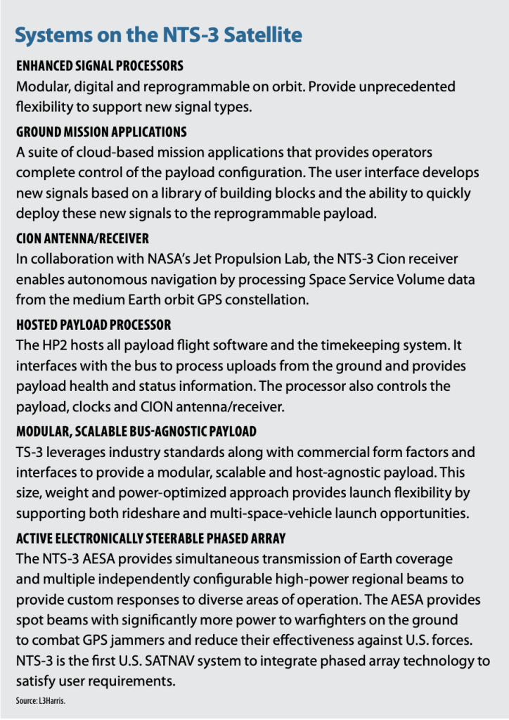
NTS-3 will carry 100 different flight experiments. According to AFRL, NTS-3 includes a space-based test vehicle, ground-based command and control, and agile software defined radios. NTS-3 will experiment with multiple integrated advanced technologies including electronically steered phased array antennas, flexible and secure signals, software-defined GPS receivers, increased ground control segment automation, and the use of commercial ground antennas.
“All the tests will be to counter current threats: jamming, spoofing, all the threats to GPS. That’s what the goal is, overcome jamming threats, put more power where power is needed, encryption, more advanced encryption for spoofing. It’s all about making GPS more resilient,” Rolli said.
“As a result of those flight experiments, the Air Force will decide how they incorporate that into the GPS enterprise,” he said. “So, it’s really all about innovation and technology, taking GPS from a 20th century technology to a 21st century technology.”
PNT Suit of Armor
As AFRL puts it, they’re “giving PNT signals a suit of armor.” NTS-3 will test a new digital signal generator that can be reprogrammed on-orbit, enabling it to broadcast new signals, improve performance by avoiding and defeating interference, and adding signatures to counter spoofing. AFRL will explore antenna configurations to provide Earth coverage and steerable regional beams in multiple frequencies and signal codes.
The spacecraft’s large L-Band, phased-array antennas allow it to generate spot beams while retaining the legacy broadcast ability for Earth coverage, according to a new AFRL video.
The system will test the Chimera signal authentication protocol, designed to verify the satellite orbit data and the range between the satellite and user, providing protection against GPS spoofing for civil users. It’s an acronym of sorts that stands for chips message robust authentication, which sends a signal that can be decoded by a key sent soon after. It’s designed to make spoofing threats easy to detect.
Future versions of Chimera can be uploaded to the satellite at any point, based on new threats, according to AFRL. The agency also noted that a cell phone gets regular updates, why not a satellite?
The space vehicle will also have multiple atomic clocks and timing sources onboard, to be used both independently and together to provide automatic clock error detection and correction.
The satellite will be entirely outside the GPS system, as it’s difficult to experiment with a technology while it’s working, Rolli said.
“It’s really hard to integrate and innovate on the current GPS system because it’s embedded in all our lives, so we came up with AFRL to set this program up where we could experiment with new signals, higher power, advanced signal capabilities, making GPS more resilient,” he said.
“So, this is completely independent where we can be free, totally in a lab environment, experimental, at a GEO orbit,” he said.
Ground Control to NTS-3
Braxton Science & Technology Group provided the ground control systems for NTS-3 (the company was acquired by Parsons Corp. in 2020).
NTS-3 will use a tailored version of Parson’s hybrid cloud ground control architecture, similar to DARPA’s Blackjack satellite and the National Oceanic and Atmospheric Administration (NOAA)’s Polar Operational Environmental Satellites.
One goal, according to AFRL, is to move from stove-piped command and control systems, each designed for a single mission, to one that can support multiple Department of Defense (DoD) satellites.
The ground control system is also using commercially available services and products, including ground antennas and monitoring receivers, according to AFRL, as well as incorporating the government-certified cloud platform.
“The NTS-3 control segment allows for easier data sharing, enhanced situational awareness, and collaboration across multiple program partners across the United States,” according to the AFRL. “By demonstrating ways of effectively managing system complexity across space, ground control, and user equipment segments, NTS-3 will develop lessons learned and meaningful test data to transition to future DoD programs.”
The NTS-3 user segment includes MITRE’s Global Navigation Satellite System Test Architecture (GNSSTA) for software-defined receivers, or SDRs, that, according to AFRL, can take full advantage of the ability to reprogram the signal on orbit. The architecture allows users to receive both legacy GPS signals and advanced signals from NTS-3.
NTS-3 will demonstrate new SDR features, including various signal modulations, transmitting data in different ways and changing broadcast parameters on a pre-defined schedule.
“In the future, warfighters equipped with SDRs capable of receiving and processing reprogrammable SATNAV signals will be able to access accurate PNT data and enhanced flexible anti-jam and anti-spoof protections,” according to AFRL.
In January, the AFRL team successfully generated signals on the actual spacecraft and received them with the experimental GNSSTA equipment, Dr. Joanna Hinks, the NTS-3 principal investigator, said at a media day event in January.
Launch Schedule
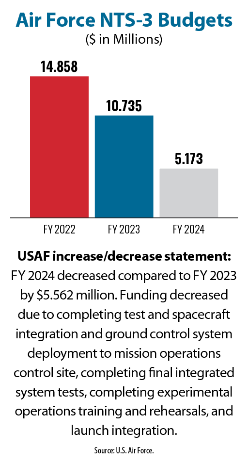
The satellite—originally slated to launch in 2022, now in the summer of 2024—is in the final stages of test and integration for launch on a Vulcan Centaur rocket built by United Launch Alliance, a partnership of Boeing and Lockheed Martin. The Vulcan was supposed to have launched by now, but the flight was delayed after an upper stage exploded during a test.
The Vulcan will have to be qualified to launch Department of Defense payloads before it will carry the NTS-3, Rolli said. Since the March test stand explosion, the launch alliance has conducted a successful engine test.
Once aloft, the NTS-3 has a one- to three-year mission life, he said. “Right now, it’s about one year for the mission experiments, but I’m sure it will go a little longer than that.”


