International astronomers linked observations from eight telescopes, including the the Canadian Hydrogen Intensity Mapping Experiment (CHIME), to pinpoint the location of a repeating fast radio burst (FRB), a little-understood and seldom-observed astronomical phenomenon that may hold keys to the origin of the universe. GPS played an important role in coordinating the telescopes and their milliseconds of data.
Forward-deployed U.S. military personnel will soon benefit from warfighter localization sensor units that provide tracking information in GPS-denied environments in a bootstrap mode. The Army Product Manager Sets, Kits Outfits and Tools awarded a $16.5 million contract to Robotic Research of Clarksburg, Maryland for WarLoc units to equip four deployed U.S. Army Brigade Combat Teams in various locations. The first batch of systems has already been shipped, and should enable soldiers on foot to keep track of each other in terrain where GPS systems are less effective.
WarLoc provides localization and positioning data for teams of warfighters or first responders in signal-denied environments such as underground facilities and inside buildings and mega-cities, according to the company. The small sensor mounts on footwear. Multiple systems work together to further enhance accuracy and maintain the localization of teams.
[Heel-mounted warfighter localization sensor units, also known as WarLoc. Photo: Robotic Research.]
The tracking system augments its GPS receiver with an inertial measurement unit. The device connects with a smartphone through Bluetooth. Robotic Research fields two form factors of the WaLoc, one mounted over the top of the boot and another that wraps around the heel. Users view data readouts through an Android-based Tactical Assault Kit. The algorithms are reportedly robust to communications failures and dropouts, and the distributed nature works well in challenging communication environments.
In lead position on a sleigh rising from the North Pole to a height of 200 meters — standard cruising altitude for global package delivery — at 2100 hours UTC on December 24 — the youngest will hopefully be asleep by then and there’s plenty of territory to cover before dawn breaks, time’s a-wasting — navigator Rudolph will see between 40 and 45 GNSS satellites glistening in the night sky.
Someone has updated 19th century American slang to resonate in the 21st century’s international commerce and shipping scene. A mysterious new electronic weapon has surfaced in China, spoofing GPS signals in a way that experts have never seen before.
The Department of Transportation (DOT) selected 11 firms to demonstrate technologies that could be used to back up the services provided by GPS should GPS signals be jammed, spoofed or unavailable.
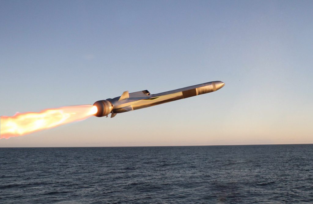
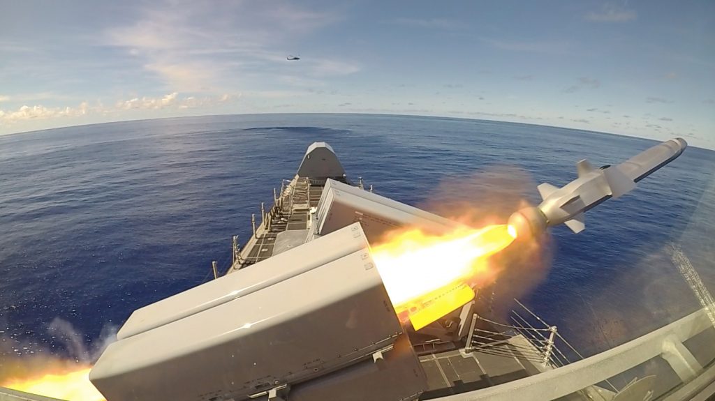
For the first time, a sophisticated GPS-guided Naval Strike Missile fired from the deck of a U.S. combat ship sailing in the Indo-Pacific region.
The USS Gabrielle Giffords launched the precision strike weapon, which “can find and destroy enemy ships at distances up to 100 nautical miles away,” according to a U.S. Navy statement. The NSM flies at high subsonic speed an “at sea-skimming altitude, has terrain-following capability and uses an advanced seeker for precise targeting in challenging conditions.”
The NSM can navigate by GPS, inertial and terrain reference systems. It is able to fly over and around landmasses, travel in sea skim mode, and make random avoidance maneuvers in the terminal phase. An imaging infrared (IIR) seeker and an onboard target database give NSM independent detection, recognition, and discrimination capabilities for targets at sea or on the coast. Its design and materials endow it with stealth capabilities. It weighs slightly over 400 kg (880 pounds) and has a range of at least 185 km (100 nm).
Known for its “sea-skimming” capability, the Naval Strike Missile can fly at very low altitudes over water and land. Photo: Kongsberg
The Navy Strike Missile launch was part of exercise Pacific Griffin, in the Philippine Sea near Guam, an exercise conducted with the Singaporean navy. It marked the second time such a missile was launched, but the first time it was fired in the Indo-Pacific region, according to the Navy.
Independence-variant littoral combat ship USS Gabrielle Giffords (LCS 10) launches a Naval Strike Missile (NSM) during exercise Pacific Griffin. The NSM is a long-range, precision strike weapon that is designed to find and destroy enemy ships. Pacific Griffin is a biennial exercise conducted in the waters near Guam aimed at enhancing combined proficiency at sea while strengthening relationships between the U.S. and Republic of Singapore navies. U.S. Navy photo by Chief Mass Communication Specialist Shannon Renfroe/Released.
The Navy awarded Raytheon a contract in 2018 for the weapons system, developed around the missile designed by Norwegian firm Kongsberg Defence & Aerospace.
The software and hardware development phase of the new GPS ground system program is now complete and the team is moving on to integration and testing, prime contractor Raytheon said in a statement.
Autonomous vehicle research firm VSI Labs took its show on the road in September, as a three-member team was driven—by their autonomous car—on a thousand-mile journey from Minneapolis to Washington D.C. The Drive East employed Trimble’s precise point positioning (PPP) technology, Trimble RTX, delivering GNSS corrections via satellite or cellular.
Gen. John E. Hyten, an officer deeply familiar with the GPS program whose testimony before Congress underscored the need to protect satellite navigation frequencies, was confirmed Thursday by the Senate to be vice chairman of the Joint Chiefs of Staff and the nation’s second highest ranking military officer.
Juniper Systems today announced the release of the Geode GNS2 Sub-meter GPS Receiver. This new release of the Geode now features connectivity with a range of iPhone and iPad devices providing users with an even more versatile and powerful tool, according to the company.
At last week’s INTERGEO expo and conference in Stuttgart, Germany and the ION GNSS+ conference in Miami, Florida, Hemisphere GNSS announced its next-generation multi-frequency, multi-GNSS S621 GNSS survey smart antenna. The all-new S621 is a complete redesign of the previous generation version (S321+) and offers added benefits and value to an already impressive range of features and functionality, according to the manufacturer.
Auto makers, ride-service providers and system integrators all anticipate the day—perhaps sooner than some think—when fully autonomous vehicles take the road. Many rigorous technical navigation challenges must be surmounted to reach that day: safety and reliability come first, before convenience and cost-savings can be realized. Innovative engineers who have solved these challenges share their lessons learned in a free webinar, Wednesday, October 2: “Inertial + SLAM: Creating the Roadmap for Autonomous Vehicles.”
A portable differential GPS-based precision landing system that guides aircraft in to spot landings in all weather, challenging terrain and surfaces conditions proved itself in a rapid set-up demo before military officials of five countries recently. A Raytheon team set up the company’s Joint Precision Approach and Landing System (JPALS) in less than an hour on a small footprint and promptly brought in multiple F-35Cs, long-range stealth strike fighters, to the same designated runway landing point every time over the course of six different approaches.
Rochester, NY – Orolia Defense & Security announced today that it has completed the acquisition of Talen-X, a U.S. company specializing in advanced Global Navigation Simulation System (GNSS) solutions and Interference, Detection and Mitigation (IDM) technologies.
Septentrio now provides GPS/GNSS receivers to rail equipment manufacturer Wabtec, also a provider of digital solutions and services to the train industry. Wabtec is implementing the receivers in its GoLINC Edge platform to provide positioning, connectivity, data storage and Positive Train Control (PTC) enhanced with the adoption of higher-precision positioning technology.