GPS signal blockage can be experienced in many environments in which a vehicle may operate: a forested road, the urban jungle, a tunnel, road “spaghetti” — you get the picture.
Inertial sensors complement GPS well, potentially bridging the gaps in GPS coverage and providing vehicle attitude information as a bonus. But there is a catch: the data streams from a GPS receiver and inertial sensors are independent and must be fused together to generate a useful stream of navigation (position, velocity, and attitude) data.
In this article the hardware and software algorithms that have been developed at the University of New South Wales (UNSW) to do this fusing operation are presented along with an example of the capabilities of the system. The article concludes with a look at some applications presently being explored and ideas for future work.
The complimentary nature of GPS and an inertial navigation system (INS) is well known. GPS provides absolute XYZ coordinates at a low data rate; INS essentially provides changes in XYZ (and attitude) at a high data rate. While GPS can suffer loss of satellite signals that can lead to no XYZ at all, INS just keeps on going but will drift as errors compound.
So, it’s a happy marriage. GPS can bound the INS errors, and INS can fill the gaps between GPS fixes.
Broadly speaking our GPS/INS system has four parts: the sensors, the synchronization component, the integration/fusion component, and data output. The system can operate in real-time or post-processing mode — the data fusion algorithms for both modes are essentially the same. In the real-time mode the algorithms run on an embedded processor on the prototype hardware device. In the post-process mode, the algorithms run on a PC.
The hardware and the system components will be detailed [in the article], but first let’s see what the system is capable of.
In the City
We took our car on a drive across Sydney, Australia, with a GPS receiver that incorporates differential corrections from a commercial satellite-based augmentation system (SBAS) and a tactical-grade inertial sensor attached. (Editor’s note: Details on all commercial products used in the UNSW project can be found in the Manufacturers section at the end of this article.) Our custom hardware synchronized and logged data from these sensors as we drove through a variety of tough environments for GPS. The data was processed on a PC and the results analysed.
In the course of this journey GPS signal loss occurred on many occasions. Most surprising was a long outage that took place as we crossed the Sydney Harbour Bridge.
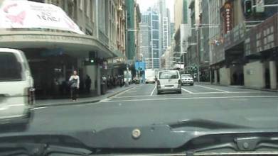
The drive took us across the Harbour Bridge and through the center of the city. The photo (above) provides a view from the car of the environment in George Street, the main thoroughfare of Sydney – tall buildings on both sides, moderate traffic, and lots of multipath.
. . .Traveling up George Street was slow due to traffic and traffic lights, but the integrated solution follows the streets and corners reasonably well, eventually emerging into an area of good GPS coverage on the other side of the city on Oxford Street.
. . .
GPS/INS System Design
The components of the test system consist of the INS, the SBAS-capable GPS receiver, and the sensor-fusing hardware and software. Several GPS receivers were used in the initial phase of the development, all of which can work with the system. The SBAS-capable unit was chosen for the final system because it is used by our project partner, the NSW Department of Lands.
The sensor fusion device (henceforth “the device”) receives data streams from the INS and GPS receiver as well as the one pulse-per-second (PPS) signal from the GPS receiver.
The device can be configured to output a solution consisting of position as well as attitude that can be logged to a compact flash (CF) card or be fed directly into a laptop running, for example, geographic information system (GIS) software. Alternatively, the device can simply log time-synchronized data for subsequent post-processing on a PC. This second option is convenient for algorithm development.
The INS is manufactured using micromachining technology. It can provide inertial measurement outputs including delta velocity and delta theta (differences in speed and angle/orientation). The inertial sensor assembly consists of six single-axis sensors, three quartz rate sensors, three vibrating quartz accelerometers, the drive electronics, preamplifier circuitry for the sensor outputs and the digital conversion electronics.
The INS has internal time-synchronization functionality, which provides a reference for evaluating the timing result from the field programmable gate array (FPGA) system. The timing performance of the system has previously been reported. (See the paper by P. Mumford et alia 2006, in the Additional Resources section in the PDF of the full article).
A commercial SBAS differential service is used to provide a GPS solution accurate to one meter or better. However, it’s important to note that, like GPS signals, an SBAS correction signal can be blocked by obstructions.
. . .
Conclusion
GPS outages are a fact of life, but navigation must go on. The prototype devices developed at UNSW can effectively integrate GPS and INS in real-time to bridge the outage gaps. Great potential exists to include this functionality in car navigation units, once the cost and performance of MEMS-based units comes down. In the meantime, specialised applications can benefit from this low-cost GPS/INS system developed at UNSW.
For the full article, including charts, graphs, resources, and photos, download the PDF (above).


