
A: Unfortunately, uninterrupted use of GNSS navigation cannot be assured due to GNSS signal susceptibility to various disruptions. All GNSS systems rely on the ability to receive weak signals from thousands of kilometers away in space, making them vulnerable to Radio Frequency Interference (RFI).
GNSS signal disruptions hinder the progress of GNSS-based technology and services. Further, disruptions due to RFI create unexpected loss of navigation, unlike more predictable features such as GNSS satellite motion relative to known obstructions. Since RFI became a noticeable problem for civil uses of GNSS in the early 2000s, there has been an ongoing effort to protect, toughen and augment GNSS signals to ensure availability, continuity and integrity for GNSS users.
Most sources of RFI to GNSS are located on or near the surface of the Earth and are much closer to users than the GNSS satellites. The most common interferers are small transmitters designed to jam GNSS signals in a limited area (e.g., hundreds of square meters) to hide the location of individual users or vehicles [1]. However, more powerful interference sources that affect aviation users over very large areas (e.g., thousands of square kilometers) have also been observed through their effects on ADS-B transmissions from aircraft [2]. While the effects of powerful interferers are often observed right away, determining the location of these interferers (so they can be deactivated) is difficult and time consuming.
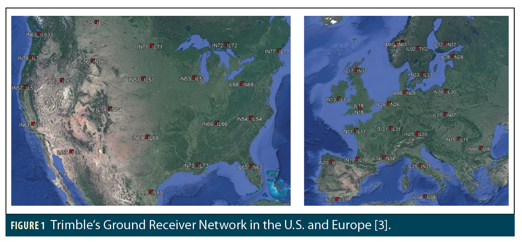
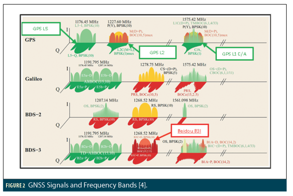
Networks of static, ground-based GNSS reference stations are also helpful in observing RFI characteristics and locating (or at least identifying) the sources of RFI. One such network has been fielded by Trimble Inc. and consists of 43 multi-frequency receivers spanning both the United States and Europe. Their locations are shown in Figure 1. Each of these receivers can generate Fast Fourier Transforms (FFT) data for multiple frequency bands. In each band, spectral data is averaged for one minute. This functionality enables authorities and researchers to analyze the mean and standard deviation of signal power across various frequency bands [3]. The frequency bands used by GNSS signals are shown in Figure 2 and encompass signals transmitted by GPS, Galileo and BeiDou (BDS-2 and -3) satellites.
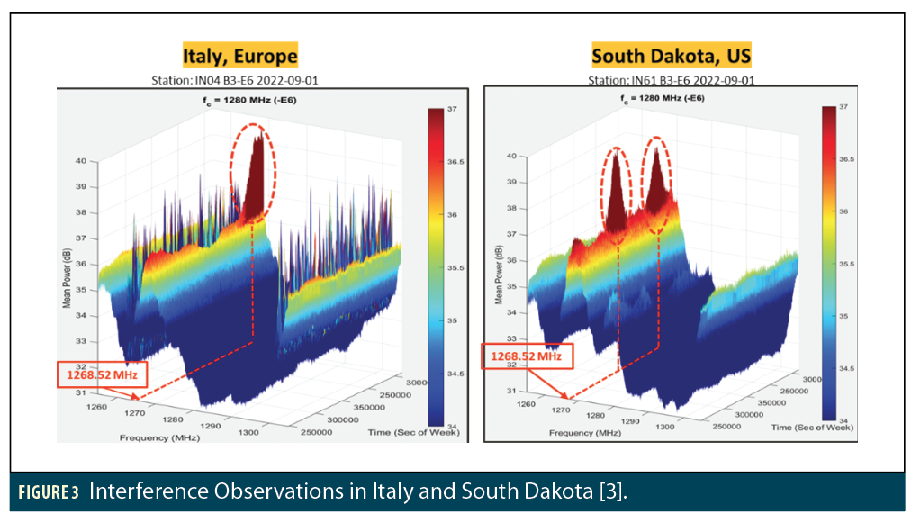
In June 2021, Trimble detected an unusual spike in signal power within the B3-E6 band at a frequency of 1268.52 MHz, which was observed simultaneously in two far-distant locations: Italy and South Dakota. Further examination revealed this spike in signal power was a consistent observation across every Trimble receiver deployed throughout both the United States and Europe. This problem was traced to interfering signals from space; specifically, from a BDS-3 satellite known by its NORAD ID of 40749. The process by which this satellite was identified as the interference source and its effects were quantified is described in detail in [3]. The key points and lessons learned are summarized here.
Interference Observations
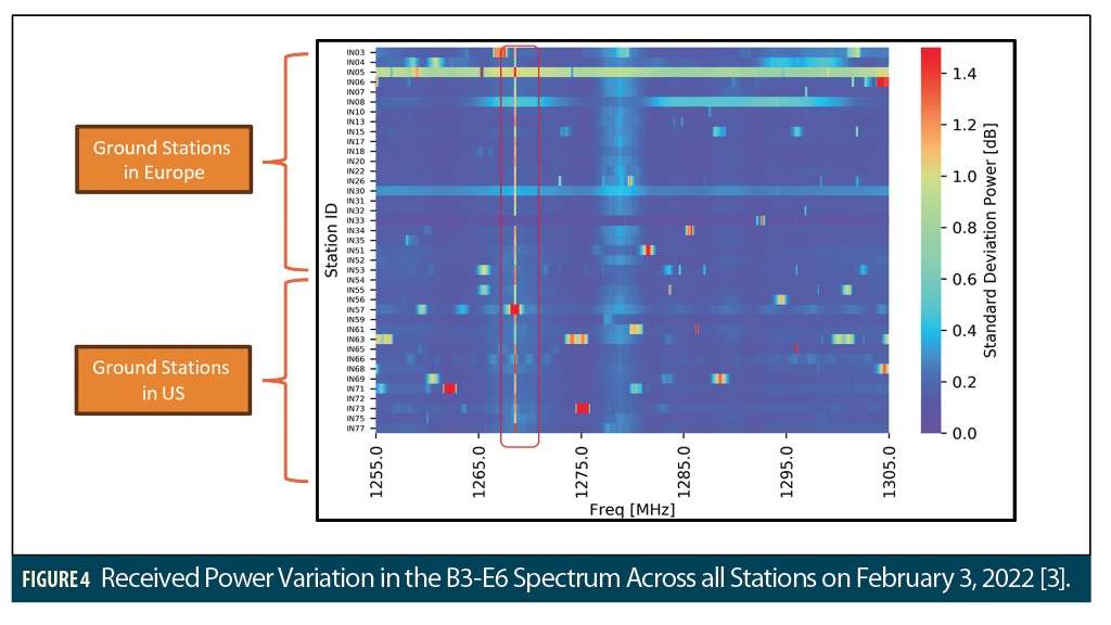
Figure 3 shows the observations of RF interference from the Trimble stations in Italy and South Dakota in terms of mean signal power (z-axis) versus frequency (x-axis) and GPS time (y-axis) on September 1, 2022. The peaks in received power occur at the BeiDou B3I center frequency of 1268.52 MHz. Once data from other stations was examined, the observed spike in power appeared to be consistently present across every Trimble receiver station in Europe and North America in a single 24-hour timeframe. Figure 4 shows the maximum standard deviation of received power at all Trimble receiver stations on February 3, 2022, as a function of frequency and station ID [3]. The red box in the plot shows significant power variations were observed on many stations at the B3I center frequency.
Identifying the Culprit
These initial results suggested the interfering signal came from space, and because the signal was centered at the B3I frequency and its effects moved relatively slowly across multiple reference stations, it was likely that a BeiDou GNSS satellite in Medium Earth Orbit (MEO) was the source. Identifying the specific offending satellite required extensive comparisons of interference patterns over time at specific ground stations and BeiDou satellite orbits as viewed by those stations.
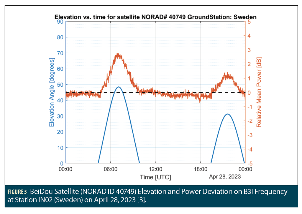
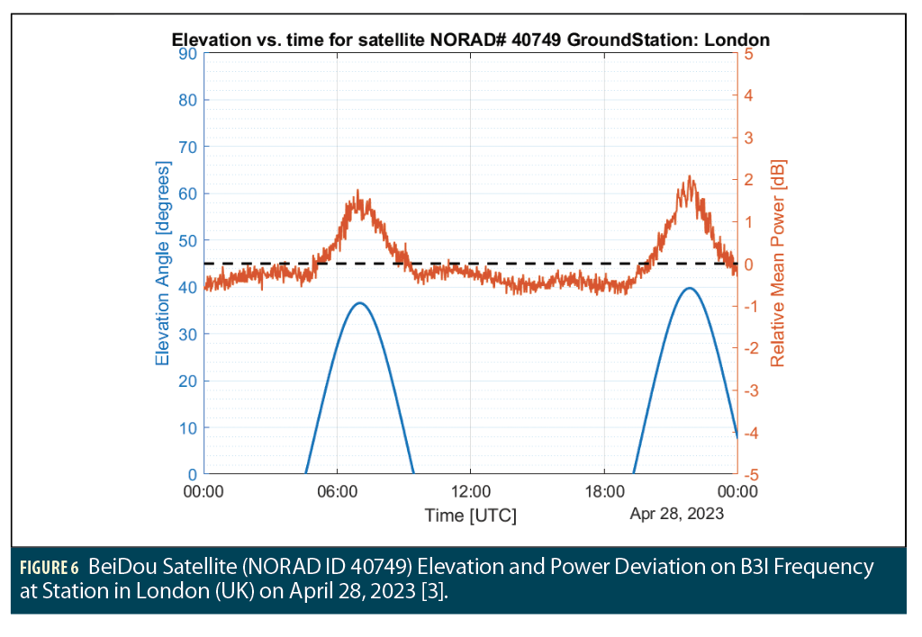
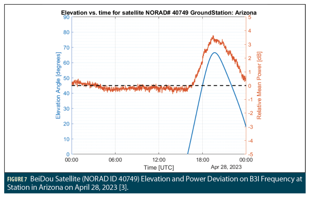
Figure 5 shows both the standard deviation of received power (on the right-hand y-axis) and the elevation angle (on the left-hand y-axis) of the BDS-3 satellite with NORAD ID 40749 at receiver station IN02 (in Sweden) on April 28, 2023 [3]. The elevation angle of this satellite matches very well with the RFI observations in this location. A search through the 27 different BeiDou satellites in MEO orbits was conducted to match the visibility of each satellite at the Trimble receiver stations with the observed signal power variations. The satellite shown in Figure 5 very clearly matched the interference seen across these stations. This is shown in Figures 6 and 7, which are in the same format as Figure 5 at ground stations in London (UK) and Arizona (USA), respectively (additional plots for other station locations are shown in [3]). The correlation between visibility of BDS-3 ID 40749 and mean received power at the B3I frequency is very clear.
Confirmation by Direct Observation
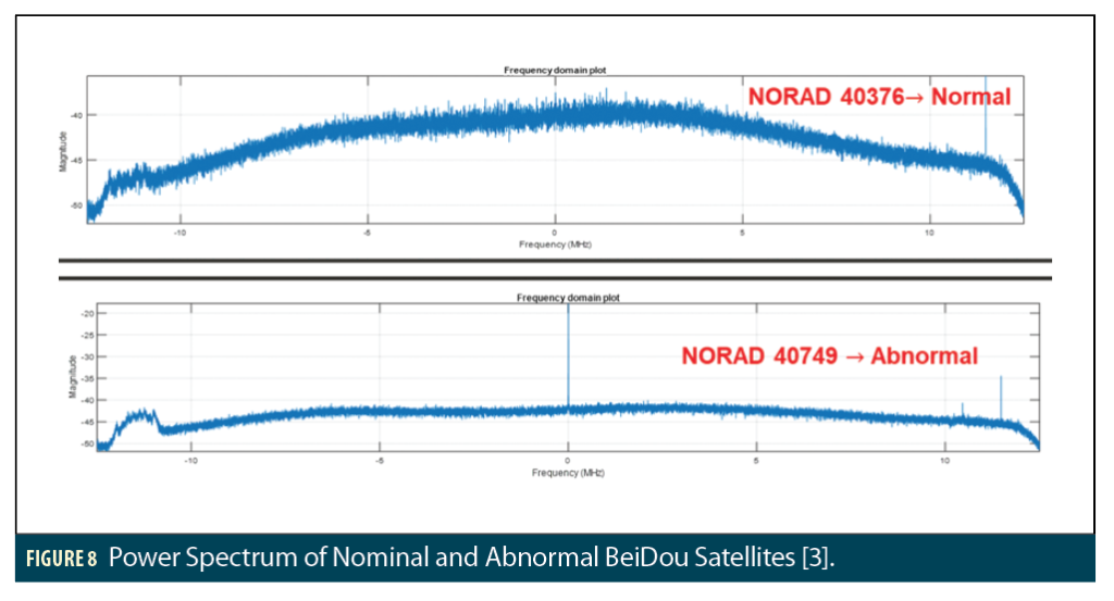
Further confirmation that BDS-3 ID 40749 was the interference source was obtained from data collected by the 1.8-meter dish antenna on the roof of the Durand Building at Stanford University and a Septentrio Mosaic X5 receiver. Figure 8 shows received signal power over a 25-MHz band centered at the B3I center frequency (1268.52 MHz) for two different BeiDou satellites.. The upper plot shows the power spectrum of a randomly selected BeiDou satellite with NORAD ID 40376, while the lower plot shows the power spectrum of the satellite identified as interfering (NORAD ID 40749) [3]. The upper plot shows the power spectrum that would be expected from BeiDou satellites transmitting B3 signals. The lower plot shows a spectrum with slightly lower power at most frequencies except the B3I center frequency, where a conspicuous narrow spike of over 20 dB in power is visible. This spike appears to be causing the RFI observed by the Trimble station network at the B3I frequency when this satellite is in view.
BeiDou Satellite Identification Problem
One challenge to identifying the interfering satellite was finding identifiers for the BeiDou satellites that matched the orbit parameters of the satellites in question. As with other GNSS constellations, the PRN codes transmitted by BeiDou satellites can change over time. Such changes are clearly reported by GPS (see, for example, the list of operating GPS satellites and PRNs at [5]) but can be difficult to keep track of for BeiDou. In this case, the satellite eventually determined to be interfering was launched in 2015 with the designation BeiDou-3S-M1S, and it started transmitting PRN C19 in November 2017. Its PRN changed to C57 in September 2018 (this can be confirmed by performing a PRN code correlation analysis, which was done to generate Figure 8). Another BeiDou satellite launched at the same time, BeiDou-3S-M2S, has been transmitting PRN C58 since some time in 2018. However, several widely used almanac trackers incorrectly identified the interfering satellite (BeiDou-3S-M1S) as transmitting PRN C58 at the time this study was conducted. To avoid such problems, the unambiguous NORAD ID numbers are recommended to identify the interfering satellite (NORAD ID 40749) and distinguish it from other BeiDou satellites [3].
BeiDou RF Interference Impacts
To evaluate the effects of RFI from the interfering BeiDou satellite on BeiDou navigation users (by affecting signals from other BeiDou satellites), BeiDou position accuracy was evaluated at Stanford using two receivers: a Trimble BX-992 receiver using B1I and B3I for positioning (based on ionosphere free measurements derived from both frequencies) and the Septentrio Mosaic receiver using B3I only. Only BeiDou satellites were used for positioning in both cases.
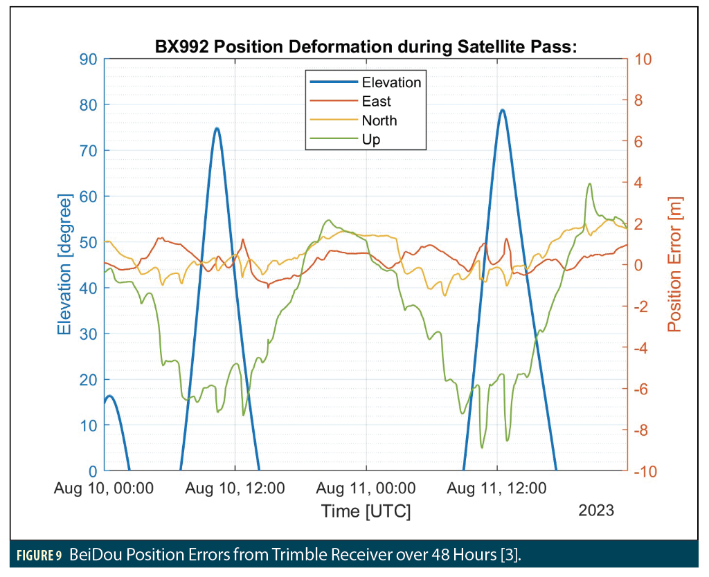
Figure 9 shows the 3D position error results from the Trimble receiver over a 48-hour period on August 10 and 11, 2023 [3]. Position error is shown on the right-hand y-axis in East, North and Up directions, while the elevation angle of the interfering BeiDou satellite is shown on the left-hand y-axis. When the interfering BeiDou satellite is in view above 20 degrees elevation, large vertical position errors occur, while East and North position errors stay roughly the same.
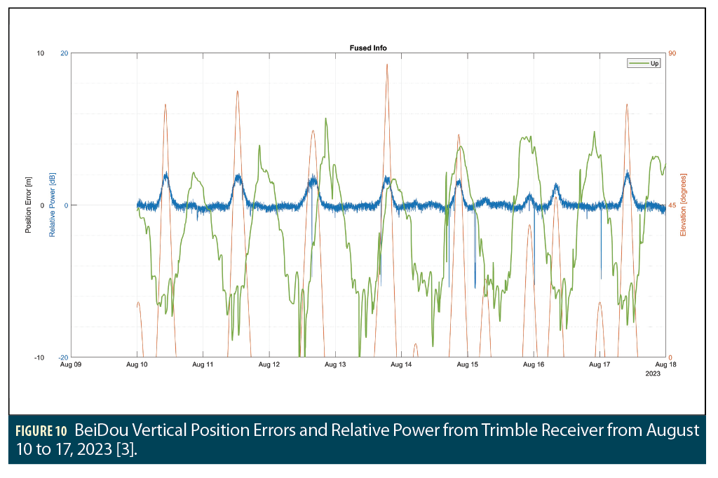
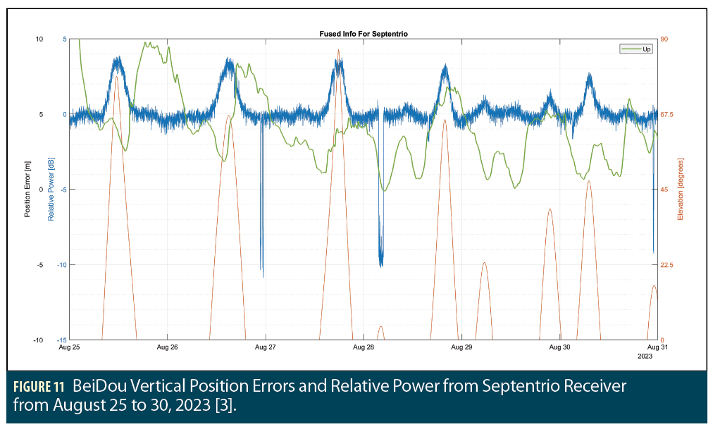
Data from the Trimble receiver was collected over eight consecutive days (from August 10 to 17, 2023, inclusive), and vertical errors and relative signal power from the Trimble receiver over these days are shown in Figure 10 [3]. In this plot, vertical error and signal power are shown on the left-hand y-axis, while the elevation angle of the interfering satellite is on the right-hand y-axis. As expected, there was a very high correlation between visibility of the interfering satellite and increased relative power. The correlation between visibility and vertical position error is weaker, as the peaks of maximum error magnitude (reaching as high as 20 meters) often did not line up with interfering satellite elevation visibility. This is particularly evident on August 12 and 13, when the largest vertical errors occurred before or around the time the interfering satellite rose into view rather than when it reached its maximum elevation. Data collected on the Septentrio receiver using B3I only from August 25 to 30 (inclusive) is shown in Figure 11 and shows a similar lack of correlation, magnified by the lack of ionosphere-free measurements from this receiver (note that all vertical position errors are positive) [3].
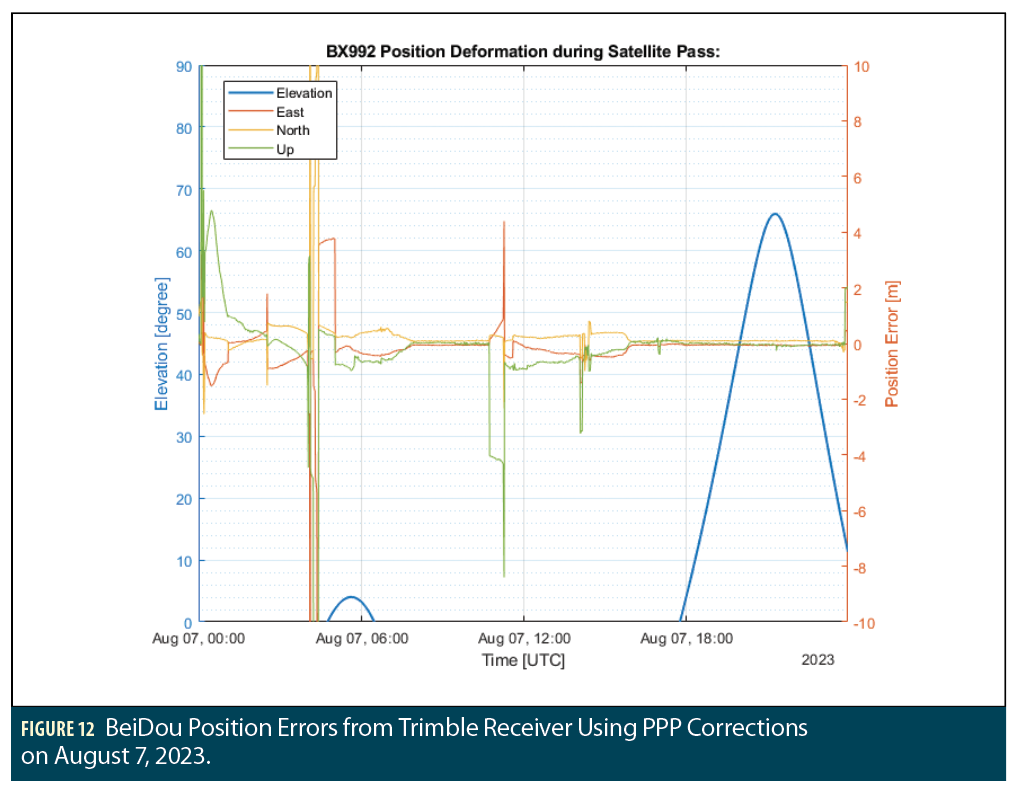
In Figure 10, the vertical position errors have a clear 24-hour periodicity, suggesting ionospheric errors may be causing them. To check this, Trimble receiver measurements corrected by Trimble’s Precise Point Positioning (PPP) service were generated for a single day (August 7, 2023) and are shown in Figure 12, with interfering satellite elevation angle on the left-hand y-axis and East/North/Up position error on the right-hand y-axis [3]. On this day, position errors are uncorrelated with the visibility of the interfering satellite. This suggests that (a) ionospheric errors or other errors removed by PPP corrections were the primary cause of the (uncorrected) Trimble receiver errors in Figures 9 and 10; and (b) the interfering BeiDou satellite had little discernable effect on BeiDou user errors.
Summary and Conclusions
This study has clearly identified one occurrence of space-based interference to GNSS from a satellite in MEO. By correlating received signal power variations to the orbits of BeiDou satellites using receivers stationed in the U.S. and Europe, the source was determined and confirmed to be a narrowband power “spike” on the B3I signal of BeiDou satellite 3S-M1S, which can be unambiguously identified by its NORAD ID of 40749. Identification of this satellite as the interference source was made more difficult by the apparent labeling confusion between the interfering BeiDou-3S-M1S (PRN C57) and the non-interfering BeiDou-3S-M2S (PRN C58). NORAD Two-Line Elements (TLEs) downloaded from Celestrak were key to resolving this confusion and identifying the correct satellite [6].
Fortunately, because the interference remains narrowly centered at 1268.52 MHz and has relatively low power, no significant adverse impact on BeiDou GNSS position accuracy has been observed. This provides some assurance that, at least at present, the interference from this satellite does not significantly affect positioning performance from BeiDou or any other GNSS constellations. However, this cannot be assured due to the potential for changes in the interference coming from NORAD ID of 40749 or the possibility of similar (but stronger) interference coming from other BeiDou satellites. In addition, the Galileo PRS spectrum has some overlap with the B3I frequency (see Figure 2). This service should also be analyzed to see if it is affected by the interfering satellite.
Acknowledgments
The authors would like to thank Stuart Riley and Trimble Inc. for generously lending time, equipment and assistance to this investigation and the Aerospace Corporation for funding this research. The authors also would like to thank the FAA and Dr. T. S. Kelso, Operator of Celestrak.
References
(1) G.X. Gao, M. Sgammini, et al., “Protecting GNSS Receivers from Jamming and Interference,” Proceedings of the IEEE, Vol. 104, No. 6, June 2016, pp. 1327-1338.
(2) Z. Liu, S. Lo, et al., “GNSS Interference: Getting to the Source,” Inside GNSS, Vol. 18, No. 3, May/June 2023, pp. 46-51.
(3) A. Patil, R.E. Phelts, et al., “Detecting Space Based Interference on GNSS Signals” Proceedings of ION GNSS+ 2023, Denver, CO, Sept. 2023, pp. 1232-1244.
(4) S. Thölert, F. Antreich, et al., “BeiDou 3 Signal Quality Analysis and its Impact on Users,” Navigation, Vol. 66, No. 4, Winter 2019, pp. 695-704.
(5) “GPS Constellation Status,” U.S. Coast Guard Navigation Center (NAVCEN) website, https://www.navcen.uscg.gov/gps-constellation.
(6) Celestrak website, https://celestrak.org/.
Authors
Akshata Patil is a graduate student in the Department of Aeronautics and Astronautics at Stanford University. She graduated with a Bachelor of Science in Aerospace Engineering from Florida Tech in 2020. Her research interests revolve around enhancing the reliability and security of perception and navigation systems used in unmanned aerial vehicles and autonomous driving vehicles.
R. Eric Phelts is a research engineer in the Department of Aeronautics and Astronautics at Stanford University. His research involves developing signal monitoring techniques and analysis for SBAS, GBAS, and ARAIM.
Yu-Hsuan Chen is a research engineer in the GPS laboratory at Stanford University. He received his Ph.D. in electrical engineering from National Cheng Kung University in 2011.
Sherman Lo is a senior research engineer at the Stanford GPS Laboratory and the executive director of the Stanford Center for Position Navigation and Time. He received his Ph.D. in Aeronautics and Astronautics from Stanford University in 2002. He has and continues to work on navigation robustness and safety, often supporting the FAA. He has conducted research on Loran, alternative navigation, SBAS, ARAIM, GNSS for railways and automobiles. He also works on spoof and interference mitigation for navigation. He has published over 100 research papers and articles. He was awarded the ION Early Achievement Award.
Todd Walter is a Research Professor in the Department of Aeronautics and Astronautics at Stanford University. He is also a member of the National Space-Based Positioning, Navigation, and Timing (PNT) Advisory Board. His research focuses on implementing satellite navigation systems for safety-of-life applications. He has received the Institute of Navigation (ION) Thurlow and Kepler awards. He is also a fellow of ION and has served as its president.


