Oxford Technical Solutions Ltd (OxTS) is an established supplier of inertial navigation systems (INS), particularly to the automotive industry. Since 1998, its products have been providing critical data about where a vehicle is, how it’s oriented and how it’s moving. More recently the company has been making a big splash in the airborne mapping sector.
“We are now getting more and more active in mobile mapping,” OxTS Product Marketing Executive Geoff Besbrode told Inside GNSS. “We have been working with a large number of clients, helping them with their projects. The University of New South Wales, for example, is using our systems to help with the restoration of coral reefs. I think we can say they were struggling with finding the best data collection system and that’s something we’ve been able to help them with.”
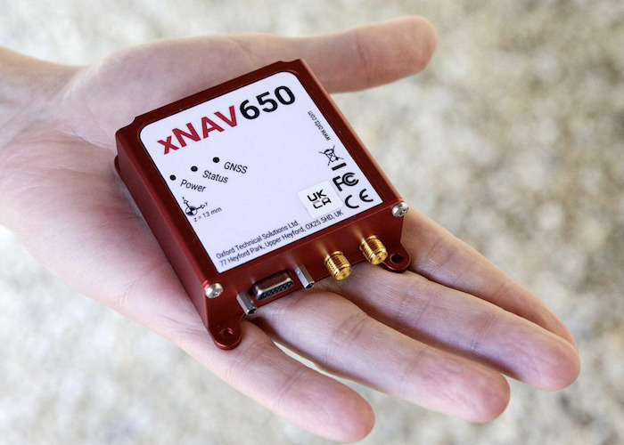
The xNAV650 is OxTS’ smallest and lightest INS. “The xNAV650 is specifically designed to work with UAV-based mapping,” Besbrode said. The self-contained module works by combining the latest MEMS inertial sensor technology with quad survey-grade GNSS, enabled for GPS, GLONASS, BeiDou and Galileo. “It is also our most competitively priced INS,” he said, “so it’s a great option when budgets are limited.”
Spreading the good news
“We’re also working with Klau Geomatics in Australia,” said Besbrode. “They’re an important LiDAR solutions provider, doing mobile mapping systems for vehicles, boats, helicopters and fixed-wing aircraft. And we’ve been working in the UK with Ordnance Survey, again helping to build mobile mapping systems.”
Besbrode talked about what makes OxTS different, better than its competitors: “It’s on the support side. We work together with our customers to understand their needs and help them develop solutions that meet those needs. We do our best to help them get the best data, and, quite honestly, with our proprietary software, data quality systems, with some very clever algorithms and the right calibrations, the quality of our navigation data is second to none.”
Our readers will know the powerful LiDAR plus INS combination is delivering a new standard of highly accurate and precise 3D point clouds in the surveying sector, and OxTS is making its case as a major player in that arena. “As a company, we are still seeing 90 percent of our revenues coming from automotive,” Besbrode said, “but we are getting smaller, with systems like the xNAV650 for UAVs, and you can expect to see some new products next year that are going to maintain this momentum in that direction. We’re going to keep putting out the latest, cutting edge technology, making it small, light and more easily affordable, bringing our customers the precision and reliability they want and expect, and I think they’re going to continue to be very happy about it.”


