NextNav and Vizsafe have formed a partnership to enhance vertical location for emergency services.
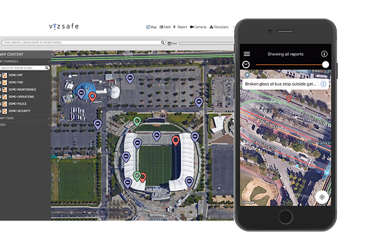
Through the partnership, NextNav’s Pinnacle Network will now be integrated into Vizsafe’s Geoaware® platform.
The Pinnacle Network provides users across the public safety and emergency services sector with a clearer picture of the z-axis location of their workforce, visitors and buildings, even across multi-story buildings, all in real time, according to a news release.
The Geoaware intelligence and awareness platform powers smart facilities, venues and cities with AI-driven mobile apps, communications, incident and visitor management. Integrating NextNav’s Pinnacle service gives the platform actionable vertical location capabilities to reduce response time and risk for both first responders and the public.
“We pride ourselves on ensuring that our solutions reduce risk, optimize resources, minimize time to respond and enhance safety of all served. As such, bringing the power of vertical location into Geoaware allows us to stay true to that commitment without compromising operational or platform integrity,” Vizsafe Founder and CEO Peter Mottur said, according to the release. “The partnership with NextNav provides a powerful third dimension to our Software as a Service application, and allows for more robust positioning, mapping and tracking capabilities to our clients in urban and suburban areas where indoor vertical location services are mission critical.”
The vertical location data is integrated into one incident management framework, allowing users to make better decisions on how to allocate personnel and resources across multi-level facilities. It also improves operational efficiencies, safety and security.
The Pinnacle Network delivers vertical location in 4,400 cities and towns and captures 90% of buildings greater than three stories in the United States, powering applications across the public safety community to support stronger situational awareness for first responders. A tier-one wireless carrier recently selected NextNav Pinnacle to bring z-axis capabilities to wireless 911 calls to enhance caller geolocation and emergency response outcomes.
“The Geoaware platform will now deliver enhanced positioning, mapping and mission-critical tracking capabilities to public and private sector customers, supporting the optimal management of critical assets, personnel and events,” NextNav Senior Director, Public Safety Rob Clark said. “Crucially, as a SaaS solution, the Geoaware platform delivers all these capabilities in a single-pane-of-glass, streamlining incident, asset and event management for organizations and ensuring that situational intelligence is immediately available and actionable.”


