eLoran Surging as Protection for GNSS and Users 

“Saying today’s eLoran is what we had in WWII is like saying your 8K Ultra HD television is the same as the 1955 tube set that only got BBC One and ITV. Some fundamentals are the same, but the technology has evolved dramatically.” – U.K. PNT expert.

Loran technology was a critical part of Allied transportation and logistics during WWII with over 70,000 receivers built for ships, aircraft, and submarines. According to the Smithsonian, by the height of the Cold War Loran coverage had extended to 70% of the northern hemisphere.

Although systems were disestablished in much of the west after the advent of GPS and in anticipation of Galileo, Loran systems have continued to provide high power, low frequency positioning, navigation and timing (PNT) services to vast areas in the east and billions of people in China, the Republic of Korea, Saudi Arabia, and Russia.

Today the modernized and more precise version, eLoran, is making a resurgence in the west as a way to greatly reduce the impacts of attacks on GNSS and demotivate those who might make attacks. It will also protect users and economies when space-based PNT is not available for whatever reason. 

This western renaissance is being led by the United Kingdom where loss of GPS due to severe space weather was first listed on its National Risk Register in 2012. The nation is establishing both a sovereign eLoran network and a fiber timing network that includes three timing centers to substantially mitigate that risk.

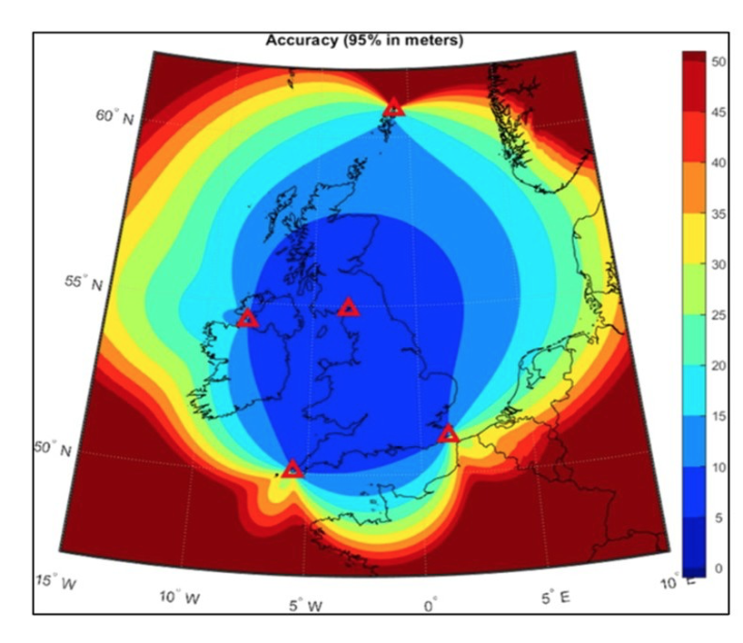
The UK has also committed to establishing four additional transmission sites to add to an eLoran timing signal that has been on-air for decades. Funding has been allocated, a search for the best locations and engagement with potential system providers and operators has begun.

France has committed to joining the U.K. with this effort, though whether they plan to create a sovereign system or merely build upon and broaden the reach of the U.K. network has yet to be announced. 

Maritime Use 

“As an island nation, we are much more reliant on maritime than others,” observed a British expert recently. “So, we are very concerned with the entire global maritime supply chain.” 

An information paper the U.K submitted to a recent International Maritime Organization (IMO) meeting describes in some detail the nation’s plan for and commitment to implement an eLoran network. Along with providing other details it says:

“The system is currently funded to reach full positioning and navigation services in England, Wales, the English Channel, Strait of Dover and Southern approaches to the United Kingdom by 2030, with full coverage to the North Sea, Ireland and Scotland from 2032. These dates are likely to accelerate due to formal partnerships with the Government of France and developing collaboration with other European partners, with formal announcements likely in autumn 2026.” 

Expanding beyond Europe, the paper also observes that eLoran systems are already serving areas in “… the Middle East, Northwest Europe and East Asia” and that it can help properly equipped vessels in those areas guard against GNSS disruption.

Some experts have observed that ships in the Strait of Hormuz could greatly benefit by accessing the network operated by the Kingdom of Saudi Arabia. The U.K. paper at IMO obliquely references this by discussing reducing “… the ability of ‘bad actors’ to disrupt strategically important flows…” and “…greater protection at those maritime chokepoints where precise navigation is most required.”

The paper also includes an invitation to other nations that operate or are interested in developing their own sovereign eLoran systems to contact the U.K. team. An industry rep subsequently reported interest from nations from nearly every region and continent. 

Recent severe GNSS jamming and spoofing events in key maritime areas, especially key choke points like the Strait of Hormuz, and to a lesser extent Bab al-Mandeb, have highlighted the need for PNT alternatives. Some maritime experts are evaluating near term eLoran solutions for these two locations as both may have sufficient service from the Kingdom of Saudi Arabia’s eLoran network for it to be a near term navigation alternative.

Aviation Applications

While often considered a maritime system, Loran has a long history of use in aviation as well. 

It was first used by military aircraft in WWII, an application that continued in the West until the late 1990s. As one example, the F-4E Phantom (top speed Mach 2.2) was equipped with a tactical Loran navigation system as part of the AN/ARN-101. Loran-C navigation was used extensively by both US military aviation and tanks during the first Gulf War (1990 – 91) because of the shortage of receivers for the new GPS system. 

The US Federal Aviation Administration (FAA) published the first Loran-related Technical Service Order (TSO-C60 for Airborne Loran-A Receiving Equipment) in May of 1959. Loran-A was the predecessor system that operated between 1800 and 2000 kHz. After Loran-C was selected as the designated radio navigation system for the Coastal Confluence Zone in 1974 and with the introduction of microprocessor technology, user equipment costs rapidly declined. By the mid-80’s there were nearly two dozen companies building user equipment for the aviation market. 

One of those companies was Texas Instruments (TI), introducing the first commercially available Loran-C aviation receiver in 1980. The following year the FAA issued TSO-C60a for airborne area navigation (RNAV) equipment using Loran inputs. By 1983, TI held Supplemental Type Certificates for installation on nearly every model of general aviation aircraft and helicopters used by commercial, military and private pilots.

Its use in civil aviation was sufficiently popular and robust that the FAA funded construction of additional Loran-C transmission sites in the middle of the U.S. to enable coast-to-coast service in the continental US. This, and Canada’s extensive network, enabled seamless Loran-C navigation from northern Mexico to southern Canada. To verify signal integrity to support non-precision approach procedures, a network of 196 monitors were installed at airports across the United States, including in Alaska.

The rapid and sustained rise of GNSS interference in so many parts of the world, along with existing and planned eLoran networks, has renewed interest in how the technology might benefit aviation. As examples:

  • 2018 IEEE paper lead by EUROCONTROL examined DME improvements, LDACS (L-band Digital Aeronautical Communication System), and eLoran. Of the three, eLoran is the only system that is beyond line of sight.
  • In 2024 a Zurich University of Applied Sciences paper “Complementing GNSS for Resilient Performance Based Navigation” recommended authorities pursue “… eDME, eLORAN and LDACS-NAV, which have the commonality that they have excellent navigation performance at a lower expected lead time into the cockpit than other systems.”
  • In June of this year “Bridging the North Atlantic: The Value of eLoran for Oceanic Airspace” was published by Zurich University of Applied Sciences. In it the author says that establishing three eLoran transmission sites in addition to those already planned by Britain could provide full coverage to the planet’s busiest oceanic air corridor.

Integration and certification requirements mean very long lead times for any new systems to be adopted in commercial aviation. Yet these papers and others have caught the attention of the Communications, Navigation and Surveillance Focus Group at the International Air Transport Association. This could possibly signal the earliest stages of that very long process.

Use by military aircraft and in general aviation as a non-integrated supplemental navigation capability is more likely in the near term. 

Multi-modal Transportation

While maritime and aviation are the highest priority modes, wide area RF-based navigation systems can often serve all forms of transportation. The international eLoran Standards Working Group demonstrated its use in a drone recently. Others have been experimenting with use in surface transportation.

Deployable eLoran 

The U.K. has also contracted for development of a deployable, tactical eLoran capability. Ministry of Defence officials have dubbed the project “Urgent Compass” and tout the technology’s exceptional resilience to interference as being crucial on the battlefield. The new system is expected to build upon the deployable “Loran-D” developed by the U.S. Air Force in 1964 and used throughout the 1960’s and 70’s. The Department of Defense re-examined the technology in the early 2000’s. Last year Germany’s armed forces also fielded and tested a tactical eLoran system.

Standards and Coordination

Several efforts are underway to develop standards for eLoran beyond those already documented in the SAE 9990 series. 

An initial international standards working group that started with the UK, Republic of Korea, and France, now includes the European Space Agency’s (ESA) Navigation Innovation Support Program (NAVISP) Engineering Team. This group convened in Seoul this July to continue its efforts. Group leaders say they want to grow it to include representatives from all interested nations.  

The International Organization for Marine Aids to Navigation (IALA) is has also been involved in this working group from the beginning. Recently the IALA council has formally agreed to take on responsibility for international coordination of eLoran operations. 

IEEE has also taken an interest. A session on eLoran and R-mode will be featured at its December navigation conference in Munich. Papers from the UK General Lighthouse Authority, Roke, Cambridge, Georgia Tech, and others have been submitted.

Complementing Space

ESA’s NAVISP has long been involved with the technology. While it is definitely not a space system, eLoran can complement and reinforce space signals. The availability of widely available terrestrial PNT systems can also make attacks on GNSS signals less likely by reducing their impact and demotivating bad actors. 

In one project NAVISP funded Roke’s development of an eLoran antenna for handheld devices in 2024. Going forward the organization intends to remain involved. For example, this October NAVISP’s Industry Days in Rome will feature a panel of experts on GNSS-independent systems that will include eLoran.

Looking Ahead

Whether eLoran coverage continues to extend to what it once was or beyond is yet to be seen. Its broad area coverage and signal characteristics so radically different from space-based systems seem for many to make it an ideal complement for GNSS. 

Yet the success of PNT signals from low earth orbit, magnetic systems, quantum sensors and the like, will undoubtedly be factors. 

What seems certain is that interference with GNSS systems and signals will continue to increase. Sovereign systems like eLoran that can serve an infinite number of users over continental size areas will continue to be of great interest. Indications are that eLoran is rapidly moving from a legacy technology to becoming a strategic component of resilient PNT.

IGM_e-news_subscribe