Uncategorized

SLAM Dance

Digital cartography and automated mapping techniques based on GNSS positioning have transformed our relationship to the physical world. The convergence of these complementary technologies are supporting the growth of commercial and consumer location-based applications that benefit from the coupling of real-time information with maps that are more current than ever — at least in environments that have access to radio signals from orbiting GNSS satellites.

Read More >

By

One Fine Day at the DLR

Richard Fischer (left) and Glen Gibbons, Inside GNSS, at Galileo Control Center, Oberpfaffenhofen, Germany

We appear at the gatehouse beside the public entrance marked “DLR” a few minutes early for our appointment — as befits a visit to this sprawling display of German aerospace expertise that is itself usually a good deal ahead of the times. It’s the day after the close of this year’s Munich Satellite Navigation Summit, and we have taken the S-Bahn down from the city.

Read More >

By
March 17, 2010

Why Walk Your Map When You Can Fly It?

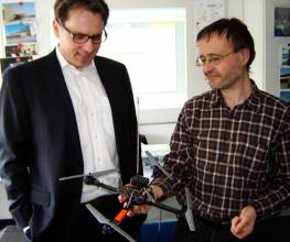
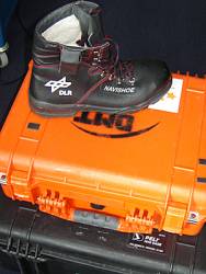
It’s hard to decide which of Patrick Robertson’s new toys — ah, I mean, remarkable scientific research tools — is the coolest: the boot with the GNSS and inertial sensors inside it that the DLR researcher is using to develop self-locating self-aware (SLAM) indoor mapping techniques, or the quadrotor intended for the same purpose, only airborne.

Read More >

By Inside GNSS
[uam_ad id="183541"]
[uam_ad id="183541"]
1 69 70 71 72 73 82
IGM_e-news_subscribe