Uncategorized Archives - Page 63 of 82 - Inside GNSS - Global Navigation Satellite Systems Engineering, Policy, and Design

Uncategorized

eVOTZ: Mobilizing Voters

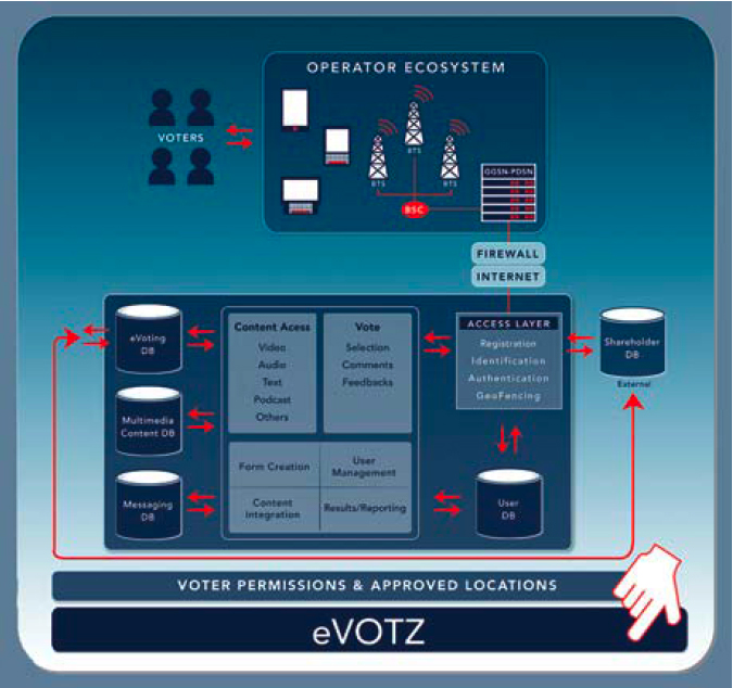
Figure 1: An overview of the eVOTZ location-based voter solution architecture

The votes are in and the USA Challenge 2010 award goes — appropriately enough — to eVOTZ, a mobile electronic balloting technology.

According to eVOTZ founder Elliot Klein, the winning application in the North American portion of the European Satellite Navigation Competition (ESNC) is designed to solve the problems of authentication and verification that have stalled previous attempts to create a secure and trustworthy e-voting solution.

Read More >

By Inside GNSS
October 1, 2010

GNSS Hotspots | October 2010

One of 12 magnetograms recorded at Greenwich Observatory during the Great Geomagnetic Storm of 1859
1996 soccer game in the Midwest, (Rick Dikeman image)
Nouméa ground station after the flood
A pencil and a coffee cup show the size of NASA’s teeny tiny PhoneSat
Bonus Hotspot: Naro Tartaruga AUV
Pacific lamprey spawning (photo by Jeremy Monroe, Fresh Waters Illustrated)
“Return of the Bucentaurn to the Molo on Ascension Day”, by (Giovanni Antonio Canal) Canaletto
The U.S. Naval Observatory Alternate Master Clock at 2nd Space Operations Squadron, Schriever AFB in Colorado. This photo was taken in January, 2006 during the addition of a leap second. The USNO master clocks control GPS timing. They are accurate to within one second every 20 million years (Satellites are so picky! Humans, on the other hand, just want to know if we’re too late for lunch) USAF photo by A1C Jason Ridder.
Detail of Compass/ BeiDou2 system diagram
Hotspot 6: Beluga A300 600ST

1. GARMIN RECALL
Olathe, Kansas USA

√ In late August, Kansas-based GPS consumer manufacturer Garmin International Inc. recalled 1.25 million Nuvi GPS units whose batteries can overheat and catch fire. In September, Nissan and Suzuki recalled Nuvi units in their vehicles. Check the special recall website to see if you are affected.

Read More >

By Inside GNSS

Launch Fever

It is not all about the satellites, of course.

And, despite the thrill of launches — the Fourth of July and every other national holiday celebration all grown up — it’s not about the rockets.

When evaluating the progress of GNSS programs, however, satellites and launches are a way to keep count — in fact, it is the way most of us do keep count.

By that measure, then, the numbers are adding up quickly.

Read More >

By Inside GNSS
[uam_ad id="183541"]
September 15, 2010

GNSS Simulation: A User’s Guide to the Galaxy

FIGURE 1: Screenshot of RF simulation software showing GPS + GLONASS + Galileo constellations

In the first article in this series (Inside GNSS, July/August, 2010) we looked at the range of tasks that require GNSS signal simulation during design, manufacturing, certification, and maintenance of GNSS equipment. The second installment (Inside GNSS, September, 2010) described a range of simulation solutions.

In this final article, we try to find a simulation solution that best suits a particular task.

Read More >

By Inside GNSS

A Search for Spectrum: GNSS Signals in S-Band, Part II

GNSS utilization of the S-band portion of the radio spectrum provides some challenges to designers of both GNSS navigation signals as well as signals used by other services, in terms of interference avoidance and signal power.

An important existing user of S-band spectrum is the Globalstar communications satellite system. The voice and data services provided by Globalstar employ the 2483.5–2500 MHz band for its satellite downlink communications to user terminals. Additionally, these satellites use multi-beam antennas to enable frequency reuse.

Read More >

By Inside GNSS
September 7, 2010

When GNSS Goes Blind

A completely GPS-based navigation solution is generally not feasible in GNSS signal–challenged environments such as urban canyons. However, even in these difficult environments a partial set of GPS signal measurements may still be available. For instance, one or two satellites are generally still visible even in dense urban canyons.

Read More >

By Inside GNSS
[uam_ad id="183541"]

NaviForum Shanghai 2010

A close brush by a passing typhoon on its opening day aside, NaviForum Shanghai 2010 mustered an impressive slate of senior executives from Chinese companies working in the navigation and telematics/location based services (LBS) field.

Read More >

By Inside GNSS
1 61 62 63 64 65 82
IGM_e-news_subscribe