Survey and Mapping Archives - Page 8 of 27 - Inside GNSS - Global Navigation Satellite Systems Engineering, Policy, and Design

Survey and Mapping

January 23, 2017

Positioning Technology in Australia Gets a $12 Million Boost

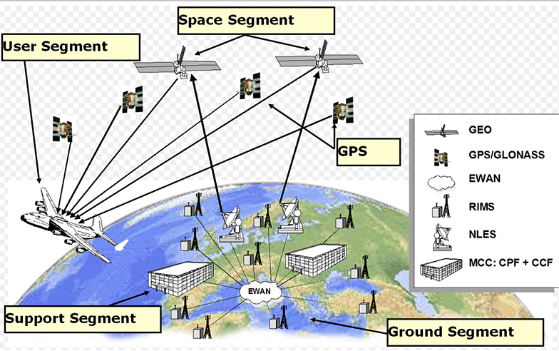
SBAS illustration with the GNSS satellites (upper left) and the communications satellite (upper right).

With the Australian government’s announcement earlier this month that it would invest $12 million in a two-year program looking into the future of positioning technology in Australia, comes plans for testing of satellite based augmentation systems (SBAS) to be undertaken, and for future applications for all four major modes of transport in Australia, as well as for potential safety, productivity, efficiency and environmental benefits.

Read More >

By Inside GNSS
January 20, 2017

Swift Navigation Co-Founders Make Forbes 30 Under 30 Consumer Tech List

Swift Navigation co-founders Colin Beighley (left) ands Fergus Noble (right).

Swift Navigation co-founders Fergus Noble (29) and Colin Beighley (28) have been honored in the 2017 Forbes 30 Under 30 Consumer Technology list.

Swift Navigation is a San Francisco-based startup that provides centimeter-accurate real-time kinematics (RTK) GPS and GNSS positioning technology for autonomous vehicles, unmanned aerial vehicles (UAVs), precision agriculture, robotics, surveying, space applications and more.

Read More >

By Inside GNSS

ODOT Deploys DT Research Purpose-built GNSS Rugged Tablets for Construction Projects

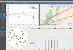
DT Research’s DT391GS Rugged GNSS Tablets

San Jose, California-based DT Research announced on January 9 the successful deployment of the DT391GS Rugged GNSS Tablets for the Oregon Department of Transportation (ODOT).

The DT391GS tablets with Intel Celeron Dual Core Processors are used as Inspector Positioning Tablets with the critical hardware and software needed for line and grade determination on stakeless highway construction projects.

The tablet comes with four GNSS module options including two from Hemisphere GNSS and two from Trimble. The GNSS options are:

Read More >

By Inside GNSS
[uam_ad id="183541"]
December 20, 2016

New Report Says Broadcom and Qualcomm Top GNSS IC Vendors

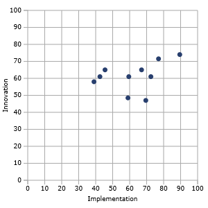
GNSS IC Vendor Competitive Assessment Vendor Matrix. Image Source: ABI Research.

A new reports says that the GNSS market landscape is growing because of rapid growth of satellite technology-enabled wearables, unmanned aerial vehicles (UAVs), new innovation opportunities, and low-cost precision receivers.

ABI Research’s new GNSS integrated circuit (IC) vendor competitive analysis says that Broadcom and Qualcomm remain the two top companies for the fourth straight year.

Read More >

By Inside GNSS
November 21, 2016

CSNC 2017: 8th China Satellite Navigation Conference

Shanghai, China

The 8th China Satellite Navigation Conference and exhibition will take place at the National (Shanghai) Center for Exhibition and Convention from May 23 through May 25 2017 in Shanghai, China.

Full papers are due now through December 20, 2016.

Online registration will be available February 15 – April 30, 2017.

Read More >

By Inside GNSS
November 17, 2016

FIG Working Week 2017

Paasitorni by the Sea, Helsinki

The International Federation of Surveyors (FIG) FIG Working Week 2017 will take place on May 29 – June 2, 2017, at the Messukeskus Expo and Convention Centre in Helsinki, Finland.

Registration will open in November, 2016. Abstract submissions are now closed.

Read More >

By Inside GNSS
[uam_ad id="183541"]
November 8, 2016

Trimble Rolls Out Catalyst GNSS Receiver, xFill Technology

Trimble Catalyst Works with Android Devices

Trimble has released Catalyst, a software-defined GNSS receiver that works with Android handhelds, smartphones, and tablets. The receiver, announced at the Trimble Dimensions conference in Las Vegas, Nevada, provides on-demand GNSS, geolocation capabilities to transform consumer devices into high-accuracy mobile data collection systems, the company said.

Read More >

By Inside GNSS
November 2, 2016

SDX GNSS Simulator Covers Four Satellite Navigation Systems

SDX GNSS Simulation with Four Simultaneous Constellations

With the addition of BeiDou B1 and B2 signals, Longueuil, Canada-based
Skydel’s (SDX) GNSS simulator now covers the four global navigation
satellite systems, the company said. SDX also added Galileo signals E5a
and E5b.

With these new updates, SDX said it is now possible to create a GNSS
simulation with a four-constellation, dual-frequency test scenario on a
single software-designed radio (SDR). The SDX GNSS simulator is ideal
for engineers, designers, and research institutes, the company said.

Skydel now offers these satellite signals:

Read More >

By Inside GNSS
November 1, 2016

ENC 2017: European Navigation Conference

EPFL Campus, Lausanne and Lake Geneva (photo A. Herzog)

The 2017 European Navigation Conference (ENC 2017) will take place on the EPFL campus in the new Swiss Tech Convention Centre (STCC) on the shores of Lake Geneva in Lausanne, Switzerland from May 9 – 12, 2017.

The call for papers is now open. The submission deadline is January 8, 2017. Registration and conference program will be available soon.

Read More >

By Inside GNSS
October 28, 2016

GNSS Notes from InterGEO

Rob Hranak, Swift Navigation vice president of business development, talks about Piksi Multi at InterGEO

This year’s InterGEO in Hamburg, Germany, featured the latest in geospatial wizardry including new navigation and positioning components and boards not only driving progress in the surveying and mapping industries, but also feeding into the wider GNSS user community.

San Francisco-based Swift Navigation came into InterGEO brandishing the all-new Piksi Multi, described as the world’s first affordable multi-band and multi-constellation receiver.

Read More >

By Inside GNSS
October 13, 2016

Eos Positioning Systems Rolls Out Arrow Gold GNSS Receiver

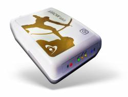
Terrebonne, Canada-based Eos Positioning Systems has released its Arrow Gold Bluetooth GNSS receiver. Arrow Gold is the first iOS, Android, and Windows Bluetooth GNSS receiver to work with GPS, Glonass, Galileo, BeiDou, Quasi-Zenith Satellite System (QZSS), and the Atlas correction service, the company said.

The palm-sized Arrow Gold receiver provides centimeter-level accuracy on iOS, Android, and Windows devices. Arrow Gold, which costs $4,395, works with such data collection systems as Esri’s Collector/Survey123 and others.

Read More >

By Inside GNSS
October 11, 2016

Hemisphere GNSS and Carlson Offer New GNSS Receivers

Hemisphere GNSS and Carlson Software have released the Hemisphere S321 and Carlson BRx6 receivers for land surveying, construction fieldwork, and marine operations.

The lightweight and compact new receivers work with GPS, GLONASS, BeiDou, and Galileo, the company said. The receivers also incorporate real-time kinematic (RTK) and L-band corrections, including optimization for Hemisphere’s subscription-based Atlas GNSS global correction service, Hemisphere said.

Read More >

By Inside GNSS
1 6 7 8 9 10 27
IGM_e-news_subscribe