The BeiDou Navigation Satellite System (BDS) is China’s contribution to the world in the domain of Global Satellite Navigation System (GNSS). The BDS is being developed by the Chinese government, mainly through military departments, with key considerations for China’s national security, economic interests and social progress.
The BeiDou Navigation Satellite System (BDS) is China’s contribution to the world in the domain of Global Satellite Navigation System (GNSS). The BDS is being developed by the Chinese government, mainly through military departments, with key considerations for China’s national security, economic interests and social progress.
After decades of development, the BDS has been recognized as one of the four big players in the field of GNSS. China has also started the development of a comprehensive positioning, navigation and timing (PNT) system with enough capabilities for air, sea, land, underground and underwater terminals, and the BDS is designed as the most important component.
From a structural point of view, the BDS is similar to the other GNSSs and composed of the satellite constellation, distributed ground facilities — including master control stations, uplink stations, and monitoring stations — and user receivers. One special feature is the inclusion of 5 geostationary satellites, raising the number of satellites in the constellation to 35. Another differentiator from the U.S. GPS, Russian GLONASS, and European Galileo system is its unique function of short message communications and position reporting capability, benefiting from the Chinese government’s strong support on both technical and financial aspects.
The BDS is designed and developed as a space infrastructure of national significance to offer two basic services: an open service free of charge and an authorized service with higher quality and integrity. At the current stage, applications based on the BDS are gradually penetrating to every corner of people’s lives and economic activities in the Asia-Pacific Region, particularly for meteorological observation, transport management and search & rescue.
Strategy of the BDS Development
Bearing in mind the mature technology and the policy of free access to open signals provided by GPS, many questions arose about why China should make substantive efforts to develop its own GNSS. However, in addition to the economic benefits created by the navigation industry, developing a domestically controlled GNSS was considered as a national security advantage.
Back in 1996 when the third Taiwan Strait Crisis started, two Chinese missiles failed to reach their targets during an exercise. Chinese military authorities believed that the event occurred due to the U.S. denial of GPS signals. Since then, China decided to develop a satellite navigation system under its own control and to complete the construction of the first generation of the BDS (BDS-1) at the beginning of 21st century.
However, as the BDS-1 was just a regional system with little commercial value, the Chinese government accepted the invitation from the European Union (EU) to join the Galileo program, with the ultimate goal of challenging the monopoly of the U.S. GPS. However, due to certain disagreements with the European Union, including China’s claim of being excluded from the key decision-making process and technical cooperation in the Galileo program, China decided to re-focus its attention on constructing its own GNSS.
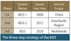
Currently, China ranks the BDS as one of the key national technical projects, supported by specific funding; the BDS program is organized pursuant to a three-step strategy: (1) the construction of BDS-1, which was finished in 2000, with the goal of providing services over all of Chinese territory; (2) the construction of the BDS-2, which has been in operation since 2012 with the purpose of covering the Asia-Pacific region; (3) the deployment of the full constellation of BDS satellites, scheduled for completion by around 2020 and intended to offer global services.
Governance Structure of the BDS
Similar to GPS and GLONASS, the BDS is a dual system used for both military and civilian purposes. However, no official source has yet affirmed that the BDS is developed and exclusively controlled by Chinese military departments, despite a widespread belief that many ties exist between the BDS and Chinese People’s Liberation Army. Official publications about the BDS simply use the expression “Chinese government” or “China”.
Furthermore, no official information on the governance structure of the BDS has been formally released, even though a general framework of BDS-related authorities can be drawn out through available open news reports and documents about the BDS. The key organizations involved in the BDS program are the following:
The China Satellite Navigation Committee (中国卫星导航系统委员会, hereinafter referred to as the CSNC). The CSNC seems to be the top decision making organ on the fundamental strategy and policy of the BDS and other Chinese PNT systems. On the one hand, the CSNC gives the opening address to the annual China Satellite Navigation Conference, which shows its important position in the supervisory framework of the BDS for domestic activities. On the other hand, the CSNC has also been working thus far as the leading authority for international cooperation involving the BDS. For example, the CSNC, on behalf of China and as the chairman of the Chinese side of China-Russia Cooperation Program Committee on Satellite Navigation, signed the “China’s BeiDou System and Russian GLONASS System Compatibility and Interoperability Cooperation Joint Statement” with the former Russian Federal Space Agency (currently known as the State Space Corporation ROSCOSMOS) in 2015.
The China Satellite Navigation Office (中国卫星导航系统管理办公室, CSNO). Under the leadership of the CSNC, the CSNO is in charge of the management work of the BDS. The CSNO is a joint office established by the competent governmental departments involved in BDS activities. For now, the CSNO is working on the system construction, application promotion, and industrialization of the BDS.
To aid in making scientific management and technical decisions, the CSNO is supported by its two internal branches, namely the Expert Committee and the Expert Teams. In addition, the CSNO is responsible for releasing top-level official policies and technical documents on the BDS both in Chinese and English as well as approving the documents on BDS-related performance and standard criteria. The CSNO also operates the official website of the BDS.
The Central Station for Satellite Navigation (卫星导航定位总站, hereinafter the CSSN). The CSSN is the Navigation Force under the leadership of Joint Staff Department of the Central Military Commission (formerly known as the General Staff Department of Chinese People’s Liberation Army). The CSSN was established as the agency for the management and operation of the BDS in 1999. Although the competence of the CSSN was described as “the research, demonstration, development, operation and application guarantee of the BDS,” it focuses more on the operation of the control segment comprising various ground stations of the BDS.
The China National Administration of GNSS and Applications (中国卫星导航定位应用管理中心, CNAGA). The CNAGA is the functional department for the application management of the BDS, which is contributing to promote the large-scale industrialization and international development of the BDS. Specifically, the CNAGA has an announced commitment to the following four aspects of the BDS:
- management of the operation and maintenance of the BDS, so as to ensure the successive and reliable provision of BDS services;
- supervision over the manufacturing enterprises of BDS user segments, so as to ensure the quality and safety of BDS services;
- development of basic application criteria and critical infrastructure of the BDS, so as to consolidate the basis of application development;
- the establishment of innovation platforms in terms of an industry alliance, industry base, industry forum and international cooperation for the BDS, so as to promote the communication and cooperation among businesses.
The National Technical Committee on BeiDou Satellite Navigation of the Standardization Administration of China (全国北斗卫星导航标准化技术委员会, hereinafter the NTCBDSSA). The NTCBDSSA was established in 2014 and is under the joint leadership of the Standardization Administration of the People’s Republic of China (SAC) and the Equipment Development Department of the Central Military Commission (formerly known as the General Armaments Department of Chinese People’s Liberation Army).
The NTCBDSSA is composed of 48 members, 7 observers and 3 liaisons, and the China Satellite Navigation Engineering Center (中国卫星导航工程中心) and the China Astronautics Standards Institute (中国航天标准化研究所) jointly comprise its secretariat. The competence scope of the NTCBDSSA covers the standardization activities concerning the management, construction, operation, application and service of the BDS. It is also in charge of developing civilian and military standards for the BDS both at the international and national level. However, all the standards proposed by the NTCBDSSA have to be approved by the CSNO before they come into force.
Based on the foregoing description, we may conclude that, in the context of the BDS, three main organizations have active roles: 1) the CSNO is responsible for the deployment and maintenance of the space segment, 2) the CSSN is operating the control segment, and 3) the CNAGA deals with supervision of the user segment, including the manufacturing of user receivers and the provision of PNT services.
In addition to these entities, as the BDS is a complicated system with interdisciplinary participation and cross-sectional dimension, many other authorities are involved in the management framework of the BDS. For example, the frequency protection of the BDS within the Chinese territory is under the responsibility of the Bureau of Radio Regulation of the Ministry of Industry and Information Technology of China, which is also known as the State Radio Office.
Policy and Law of the BDS
Different from its competitors in the domain of satellite navigation, particularly the EU and the United States, China owns a unique socialist system of laws with Chinese characteristics. China has recently placed great emphasis on the fundamental principle of governing the country by law. Accordingly, the rule of law has been proposed very frequently for China’s space industry.
However, China is still one of a few space powers that lacks a basic space law. Therefore, setting up a comprehensive legal framework for the BDS will arguably require some time. Until that can be achieved, a series of policy documents would have to retain the dominant role, even though policy solutions are much less effective than legal arrangements in the Chinese context. These include the following policy documents:
White Paper on China’s Space Activities. This white paper is currently the basic document relating to China’s space policy, and it always places great importance on the development of the BDS. The document has thus far been updated to the fourth version in 2016.
After summarizing certain achievements in the field of the BDS since 2006, the third version (2011) addresses the three-step strategy of the BDS and lists the BDS as one of the priority projects in key fields; the latest version (2016) requires the improvement of BDS applications and promotion of international cooperation of the BDS.
White Paper on China’s BeiDou Navigation Satellite System. This white paper was released in June 2016, which makes it the latest policy document concerning the BDS specifically. This white paper lays down the goals and principles related to the development of the BDS and again addresses the BDS three-step strategy.
According to the document, China is committed to ensuring the safe and reliable operation of the BDS and providing continuous, stable and reliable open services to users free of charge. In addition to protecting the utilization of the BDS frequency spectrum, the white paper also requires promotion of BDS applications and industrial development by taking multiple measures, as follows:
- establishing an industrial supporting system, through making industrial policies, building equitable market environment, enhancing standardization process, and building a comprehensive service system of location data;
- establishing an industrial application promotion system, through improving the BDS application in key sectors related to national security and economy, pushing forward close integration of the BDS with state strategy on industrial and regional development, guiding mass market applications of the BDS in the fields of smart phones, vehicle-borne terminals, and wearable devices;
- establishing an industrial innovative system, by enhancing the research and development of basic products based on the BDS, encouraging and supporting the construction of a technology innovation system that relies on the market players as the main factor combined with the efforts of academic institutes. The industrial system is called on to promote the integrated development of the BDS with infrastructures and technologies including the “Internet+”, “Big Data”, the “Internet of Things”, communications, remote sensing, and other emerging industries.
As for international cooperation of the BDS, the Chinese government plans to further the efforts by
- strengthening compatibility and joint applications with other navigation satellite systems;
- using frequency and orbital slot resources according to international rules, particularly the Radio Regulations by the International Telecommunication Union (ITU);
- promoting the ratification of the BDS in accordance with international standards, particularly those of the International Civil Aviation Organization (ICAO) and the Third- Generation Mobile Communication Standard Partnership Project (Note that the BDS already gained recognition from the International Maritime Organization (IMO) in November 2014);
- participating in multilateral activities in the field of international satellite navigation, such as the conferences and academic exchanges hosted by the International Committee on Global Navigation Satellite Systems (ICG);
- promoting international applications of the BDS by intensifying publicity and popularization of the BDS, and implementing internationalization projects in the field of policy, market, law and finance, and so forth.
Medium and Long Term Development Plan for China’s Satellite Navigation Industry. This policy document was approved by the State Council and released by its General Office in September 2013. The Plan makes overall arrangements for medium- and long-term development of the BDS and other satellite navigation industry developments. The Plan first analyzes the current situation of satellite navigation that the BDS faces at home and abroad; second, it lays down the guidelines and principles to develop China’s navigation industry.
More importantly, the development plan indicates the year of 2020 as the critical timeline for China to form a new innovation-oriented development pattern. To achieve that goal, the development plan lays out six specific directions and tasks and five major projects to develop BDS-related industry before the year of 2020. Several measures are proposed to support this initiative.
Several Opinions on the Promotion of Geo-information Industry Development. This policy document was released by the General Office of the State Council in January 2014 with the purpose of promoting the development of China’s geo-information industry as a whole. Accordingly, the industry development of the BDS is an important element to allow the integration between geo-information and PNT services, which is recognized as an important way to facilitate people’s lives.
Several Opinions on Promotion and Application of the BeiDou Satellite Navigation System by China’s National Administration of Surveying, Mapping and Geo-information. This policy document was issued by China’s National Administration of Surveying, Mapping and Geo-information in March 2013, with the purpose of implementing the prior policy documents. This policy document obviously was made from the perspective of BDS users. It urges the competent regional authorities on surveying, mapping and geo-information to accelerate the promotion of application and industrialization of the BDS, and to safeguard China’s national security and interest within their competence.
Provisions of the Chinese People’s Liberation Army on the Administration of the Satellite Navigation Application. This military rule was issued by the former General Staff Department of Chinese People’s Liberation Army (currently known as Joint Staff Department of the Central Military Commission) and became effective on June 1, 2014. Although it has a lower status than “law” or “regulation”, this “rule” for now is the only legal-binding document in effect that relates directly and specifically to BDS applications.
The full text of this rule is not open to the public; however, the rule is known to be structured in 7 chapters, containing 36 articles, which specify the duties and responsibilities, programming and planning, application and approval, organizations, technical support, and security management regarding utilization of the BDS by Chinese military troops, particularly in combat situations.
In addition, some normative documents having no legal effect play an important role in the specific management of BDS-related activities. These documents are issued by
- the CNAGA, for example: Quality Management Provisions for BeiDou Civil Service, Authorized Management Methods of Quality Inspection Agencies for BeiDou Products, Performance Standard of Shipborne BeiDou Receiving Devices, and other authoritative information regarding BDS application management, certification of the BDS service and application, and inspection of BDS products’ quality;
- the CSNO, for example: BeiDou Navigation Satellite System Signal In Space Interface Control Document Open Service Signal, BeiDou Navigation Satellite System Open Service Performance Standard, Terminology for BeiDou Navigation Satellite System (BDS), and 16 other standards prepared especially for the BDS.
Way Forward
Although China has made great achievements on the research, development, and construction of the BDS system, China’s deployment of the management of the BDS, including institutional, policy, and legal arrangements, is still in its infancy. This may, somewhat, clip the wings of its development, operations, and applications and may constrain its further popularization both at domestic and global level.
Although a vague governance structure has been delineated by the authors based on the currently available materials, the respective roles and responsibilities for the BDS still have to be well defined and disclosed in the form of law. The overlapping of responsibilities between the CSNO and the CNAGA should not be ignored. More importantly, a civilian-military coordination mechanism should be developed as soon as possible in order to promote the development of civil applications and to increase BDS commercialization both at internal and international level.
It is true that the strategy, goals, principles and action plans for the BDS are reflected by several policy documents, but none of them assigns specific tasks to each department; this inconsistency potentially compromises the implementation and enforceability of BDS policies in practice. Even though a law related to the BDS would be more legally binding than the planning and opinions that we have described here, only one classified military rule is available thus far for China’s GNSS program.
Fortunately, a regulation on satellite navigation proposed by the Equipment Development Department of the Central Military Commission has been listed into the Research Items of the State Council Legislative Workplan for 2016, as one of the of Legislative Projects Related to Implementing the National Security Strategy and to Protecting National Security. Even though the term “Research Items” represents low priority, at least it lights up the hope for a future legal regulation of the BDS.
Additional Resources
[1] BeiDou Satellite System (BDS), official website.
[2] China National Administration of GNSS and Applications, official website.
[3] China Satellite Navigation Office, Report on the Development of BeiDou Navigation Satellite System, Version 2.2, December 2013
[4] China Satellite Navigation Office, BeiDou Navigation Satellite System Open Service Performance Standard, Version 1.0, December 2013
[5] China Satellite Navigation Office, BeiDou Navigation Satellite System Signal In Space Interface Control Document Open Service Signal, Version 2.0, December 2013
[6] State Council Information Office of the People’s Republic of China, China’s BeiDou Navigation Satellite System (Foreign Languages Press, 2016).


