Global Navigation Satellite Systems Engineering, Policy, and Design
Global Navigation Satellite Systems Engineering, Policy, and Design
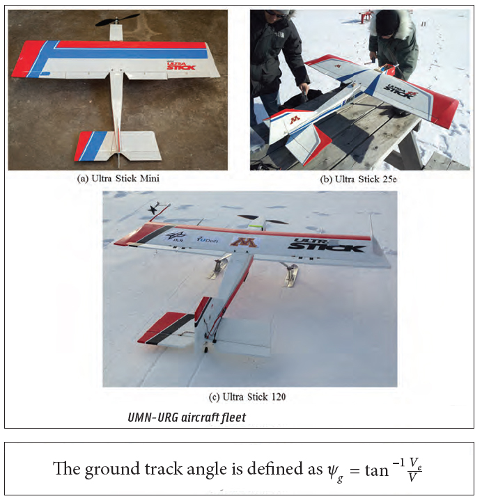
Return to main article: "An Airborne Experimental Test Platform"
By Inside GNSS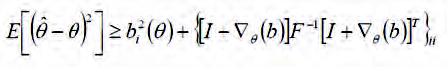
 Michel Monnerat’s Favorite Equation
Mentors
By Inside GNSS
 One of 12 magnetograms recorded at Greenwich Observatory during the Great Geomagnetic Storm of 1859
 1996 soccer game in the Midwest, (Rick Dikeman image)
 Nouméa ground station after the flood
 A pencil and a coffee cup show the size of NASA’s teeny tiny PhoneSat
 Bonus Hotspot: Naro Tartaruga AUV
 Pacific lamprey spawning (photo by Jeremy Monroe, Fresh Waters Illustrated)
 “Return of the Bucentaurn to the Molo on Ascension Day”, by (Giovanni Antonio Canal) Canaletto
 The U.S. Naval Observatory Alternate Master Clock at 2nd Space Operations Squadron, Schriever AFB in Colorado. This photo was taken in January, 2006 during the addition of a leap second. The USNO master clocks control GPS timing. They are accurate to within one second every 20 million years (Satellites are so picky! Humans, on the other hand, just want to know if we’re too late for lunch) USAF photo by A1C Jason Ridder.
  Detail of Compass/ BeiDou2 system diagram
 Hotspot 6: Beluga A300 600ST

JPL uses GPS to find Sierra Nevada water weight; Near collision of drone and regional jet prompts questions, West Antarctic ice sheet melt at “point of no return,” First Galileo FOC satellites at launch site, China’s GBAS tested in Tianjin
By Inside GNSS
Well, I could have taken up the subject of the deteriorating condition of U.S./Soviet, excuse me, U.S./Russian relations. But there are only so many windmills that I have time to tilt at.
So, rather than tracing the dissolution of bilateral GNSS cooperation in the wake of Russia’s reclaiming the Crimea and, who knows, perhaps eventually a large swath of eastern Ukraine, I thought I’d turn to an only slightly more remediable issue — GNSS carriage requirements.
By Inside GNSS Doug Taggart, Overlook Systems Technologies
 In the “gee-whiz” awesomeness of proliferating GNSS apps, it’s sometimes hard to remember that Global Positioning System originated as a military system designed to meet strategic and tactical needs on the battlefield.
And, with the U.S. Air Force continuing its 40-year mission as the executive agent for sustaining GPS, that undiminished military role plays no small part in ensuring the availability and reliability of the U.S. contribution to the GNSS system of systems.
By Inside GNSS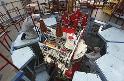
 Working on a GLONASS-M satellite at Reshetnev ISS
The Russian GLONASS system, which had appeared to be recovering from a series of organizational and technical problems in recent years, suffered two major disruptions during April.
By Inside GNSS
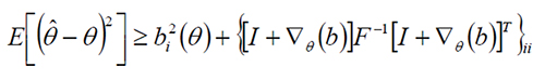
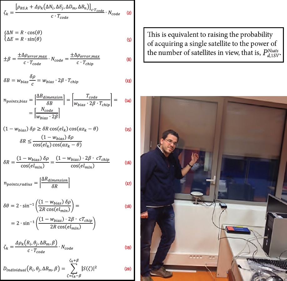 Clockwise from left: (a) article equations, (b) the probablility of acquiring a single satellite to the power of the nyumber of satellites in view, (c) Indoor scenario of signal collection at ISAE navigation lab, Toulouse
Working Papers explore the technical and scientific themes that underpin GNSS programs and applications. This regular column is coordinated by Prof. Dr.-Ing. Günter Hein, head of Europe’s Galileo Operations and Evolution.
By Inside GNSS