 One of 12 magnetograms recorded at Greenwich Observatory during the Great Geomagnetic Storm of 1859
 1996 soccer game in the Midwest, (Rick Dikeman image)
 Nouméa ground station after the flood
 A pencil and a coffee cup show the size of NASA’s teeny tiny PhoneSat
 Bonus Hotspot: Naro Tartaruga AUV
 Pacific lamprey spawning (photo by Jeremy Monroe, Fresh Waters Illustrated)
 “Return of the Bucentaurn to the Molo on Ascension Day”, by (Giovanni Antonio Canal) Canaletto
 The U.S. Naval Observatory Alternate Master Clock at 2nd Space Operations Squadron, Schriever AFB in Colorado. This photo was taken in January, 2006 during the addition of a leap second. The USNO master clocks control GPS timing. They are accurate to within one second every 20 million years (Satellites are so picky! Humans, on the other hand, just want to know if we’re too late for lunch) USAF photo by A1C Jason Ridder.
  Detail of Compass/ BeiDou2 system diagram
 Hotspot 6: Beluga A300 600ST

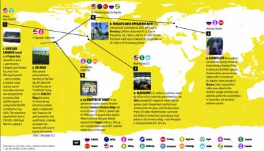
JPL uses GPS to find Sierra Nevada water weight; Near collision of drone and regional jet prompts questions, West Antarctic ice sheet melt at “point of no return,” First Galileo FOC satellites at launch site, China’s GBAS tested in Tianjin
JPL uses GPS to find Sierra Nevada water weight; Near collision of drone and regional jet prompts questions, West Antarctic ice sheet melt at “point of no return,” First Galileo FOC satellites at launch site, China’s GBAS tested in Tianjin
1. WATERLOGGED
Pasadena, California and Sierra Nevada Mountains
√ California’s dense GPS network — installed for earthquake measurement — is now tracking the state’s most elusive commodity. The Jet Propulsion Lab in Pasadena used GPS to measure the water weight pressing down on California’s Sierra Nevada mountains. They used highly precise GPS receivers at 1,069 sites to measure seasonal ground level changes, then calculated how much water it would take to make the difference. Bottom line? About two feet from fluffiest snowpack to summer dust.
(May 8, 2014) Jet Propulsion Lab News Release
2. CLOSE CALL
Tallahassee, Florida and Washington DC
√ A US Airways regional jet coming in for a landing under visual flight rules in Tallahassee, Florida, nearly sucked a high- flying drone into its engines last March, and it caused a ruckus when it came to light in May. What looked like a camouflaged F-4 model aircraft wasn’t supposed to be at 2,300 feet, but the traffic rules of our highways in the air are far from clear. The FAA will clarify UAV regulations by 2015 at the earliest, but that’s not soon enough, said testy stakeholders.
Inside GNSS Recorded Webinar:
UAS in the NAS – What Next? with NASA’s senior advisor for Unmanned Systems and the FAA’s UAS Test Site program manager.
3. BEDROCK BLUES
Antarctica
√ On May 12, NASA announced that a big part of the West Antarctic Ice Sheet is melting and has “passed the point of no return.” Confirmed by observation: Glacier flow is accelerating, the bedrock has few hills or bumps to slow the runaways and the land bed slopes toward the interior, facilitating contact between warm ocean water and floating ice. This stunning news was made possible by new, improved maps of the area — and part of that improvement is due to ANET, a GPS and seismic network that shows the interaction between ice sheet and bedrock. Wonderful technology — bad news.
(May 12, 2014) NASA News Release
BEDMAP2 Antarctic new and improved map
4. READY, SET…
Kourou, French Guiana
√ The first Galileo full operational capability (FOC) satellites arrived in Kourou, French Guiana on May 7 for launch on Soyuz flight VS09 during the last two weeks of August. Galileo SVs are named after a child in each EU country and these two are “Doresa” and “Milena.” The FOC launch suffered more than a year-long delay, much to the embarrassment of everyone involved.
(May 7, 2014) Arianespace news release
Inside GNSS Nov-Dec 2013 issue:
Questions in Wake of New Galileo Delay
5. ONE METER
Tianjin, China
√ China’s ground-based augmentation system (RBN- DBDS) is accurate to “within one meter,” Xinhua news service said on May 9. It passed 130 days of test trials in the northern national municipality of Tianjin, home of one of the world’s largest man-made ports. It will be used with GPS and BeiDou for better accuracy in maritime applications.
(May 7, 2014) Xinhuanet: China’s GBAS
Images and credits (from illustration above)
1. USGS GPS Station, The Husband, Three Sisters wilderness, Oregon. 2007 photo by Dave Sherrod, USGS. Used by JPL for their press release on the GPS water study.
2. A remote-controlled F4 phantom jet model aircraft, similar to the drone a pilot thought had collided with his Canadian regional jet.
3. GPS station CRDI Cordiner Peak in Western Antarctica. Crews fly up to four
hours from their base at the South Pole to maintain remote stations. Four GPS stations and 11 seismic stations received visits for battery swaps or repairs to power systems and data communications during December 2013. (UNAVCO photo).
4. The first two Galileo FOC satellites arrive in Kourou. (OHB photo).
5. Northern bulwark, Tianjin Port (Wikipedia, 2013 photo by amazingloong.)

