A Comprehensive Reference for OPUS

CORS and OPUS for Engineers
Edited by Tomás Soler
PUBLISHED BY THE AMERICAN SOCIETY OF CIVIL ENGINEERS

CORS and OPUS for Engineers
Edited by Tomás Soler
PUBLISHED BY THE AMERICAN SOCIETY OF CIVIL ENGINEERS
Consumer demand for positioning information is currently being met by a plethora of wireless positioning technologies. The most popular consumer positioning technology, GNSS, is only one option along with several methods that use cellular networks to provide location, such as wireless local area networks (WLANs), wireless personal area networks (WPANs), radio frequency identification (RFID) tags, and ultrawideband (UWB) communications.
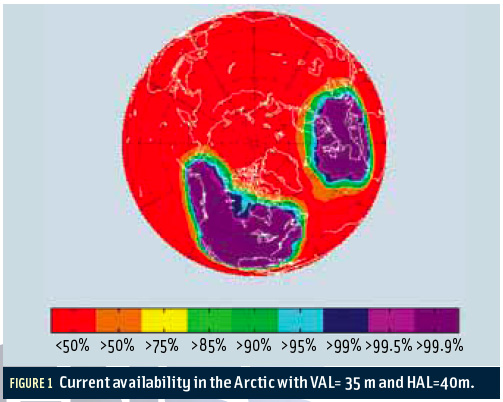
By Inside GNSS FIGURE 1: Current availability in the Arctic with VAL=35 m and HAL=40m.
The Arctic houses an estimated 90 billion barrels of undiscovered, technically recoverable oil and 44 billion barrels of natural gas liquids according to the U.S. Geological Survey. These potential energy reserves represent 13 percent of the untapped oil in the world.
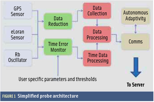
By Inside GNSS FIGURE 1: Simplified probe architecture
GNSS vulnerability is rightly one of the most talked about topics of 2011.
By Inside GNSS FIGURE 1: GPS III On Orbit
In May 2008, Lockheed Martin Space Systems Company received a contract from the U.S. Air Force to develop a new, third generation of GPS satellites. The GPS III space vehicle (SV) has been designed (Figure 1, see inset photo, above right) and is now being built to bring new future capabilities to both military and civil positioning, navigation, and timing (PNT) users throughout the globe.
By Inside GNSS
Completion of the GLONASS constellation, delayed by a series of mishaps in Russia’s space program, may move ahead with a launch in September, according to Russian sources, if the Soyuz carrier is cleared for further use. A tentative launch from the Plesetsk space center has been set for September 25. The launch was originally scheduled for August 15.
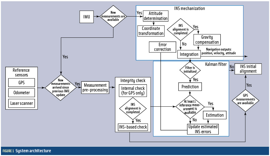
By Inside GNSS FIGURE 1: System architecture
Cooperative vehicle safety applications should preferably have two-meter horizontal accuracy and six-meter vertical accuracy, all with a 95-percent availability. The solution must be developed to incorporate lower-cost sensor options, specifically, lower-cost inertial measurement units that can be generally characterized by the gyro drift of 100 degrees per hour and an accelerometer bias force of twice its mass times gravity (two milligals).
By Inside GNSS