201010 October 2010 Archives - Inside GNSS - Global Navigation Satellite Systems Engineering, Policy, and Design

201010 October 2010

September 15, 2010

GNSS Simulation: A User’s Guide to the Galaxy

FIGURE 1: Screenshot of RF simulation software showing GPS + GLONASS + Galileo constellations

In the first article in this series (Inside GNSS, July/August, 2010) we looked at the range of tasks that require GNSS signal simulation during design, manufacturing, certification, and maintenance of GNSS equipment. The second installment (Inside GNSS, September, 2010) described a range of simulation solutions.

In this final article, we try to find a simulation solution that best suits a particular task.

Read More >

By Inside GNSS

A Search for Spectrum: GNSS Signals in S-Band, Part II

GNSS utilization of the S-band portion of the radio spectrum provides some challenges to designers of both GNSS navigation signals as well as signals used by other services, in terms of interference avoidance and signal power.

An important existing user of S-band spectrum is the Globalstar communications satellite system. The voice and data services provided by Globalstar employ the 2483.5–2500 MHz band for its satellite downlink communications to user terminals. Additionally, these satellites use multi-beam antennas to enable frequency reuse.

Read More >

By Inside GNSS
[uam_ad id="183541"]
September 11, 2010

“Michibiki,” Japan’s First QZSS Navigation Satellite, Reaches Quasi-Zenith Orbit

QZSS satellite separaes from the launcher (photo by Mitsubishi Heavy Industries)

(UPDATED September 27) Japan’s first quasi-zenith satellite launched successfully from the Tanegashima space center on September 11, 2010 and reached its quasi-zenith orbit on Monday, September 27.

Michibiki means to guide or lead the way, appropriate for the first entry into Japan’s satellite augmentation program that will vastly improve GNSS accuracy over Japan and the rest of East Asia.

Read More >

By Inside GNSS
September 7, 2010

When GNSS Goes Blind

A completely GPS-based navigation solution is generally not feasible in GNSS signal–challenged environments such as urban canyons. However, even in these difficult environments a partial set of GPS signal measurements may still be available. For instance, one or two satellites are generally still visible even in dense urban canyons.

Read More >

By Inside GNSS

NaviForum Shanghai 2010

A close brush by a passing typhoon on its opening day aside, NaviForum Shanghai 2010 mustered an impressive slate of senior executives from Chinese companies working in the navigation and telematics/location based services (LBS) field.

Read More >

By Inside GNSS
August 27, 2010

GLONASS-M Satellite Launch Highlights Ambitious Promotion of Russia’s Revitalized GNSS

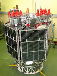
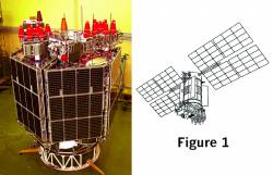
GLONASS-M satellite. Figure/photo, JSC “Academician M.F. Reshetnev “Information Satellite Systems”

A Proton-M carrier rocket successfully launched three GLONASS-M satellites into orbit early this morning (September 2, 2010, Moscow time) from the Baiknour space center in Kazakhstan. Another launch on November 30 will send three more M-type satellites into orbit, and the first GLONASS-K is scheduled to go up on December 25.

The imminent completion of a full constellation by the end of the year is accompanied by a vigorous policy initiative to promote Russia’s revitalized GNSS.

Read More >

By Inside GNSS
[uam_ad id="183541"]

SVN62, the First GPS IIF Satellite, Is Set Healthy

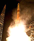
SVN62 launch (ULA)

The U.S. Air Force declared the first GPS Block IIF satellite (SVN62) operational today (August 27, 2010), changing the spacecraft’s navigation signal status to healthy at about 10:10 a.m. (EDT or 4:10 a.m. UTC). 

Launched May 28, the satellite became the responsibility of the USAF 50th Space Wing on August 26,

Read More >

By Inside GNSS
August 24, 2010

CDR Passed: GPS III Ready for Build Phase

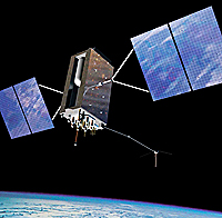
Artist’s rendering of GPS III satellite. Lockheed Martin image

More than two years into a multi-billion-dollar contract, the Lockheed Martin team developing the U.S. Air Force’s next-generation GPS Block III satellites continues to defy the physics of large aerospace programs by successfully completing the program’s Critical Design Review (CDR) phase last week — two months ahead of the baseline schedule.

Read More >

By Inside GNSS
August 1, 2010

China Launches 5th Compass (Beidou-2) Navigation Satellite — First IGSO

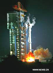
Fifth Beidou-2 satellite launched. Xinhua/Du Cai photo

[Updated August 1, 2010] China’s state news agency has reported that the fifth Compass (Beidou-2) satellite — the system’s first inclined geostationary orbit (IGSO) spacecraft — was launched successfully at 5:30 a.m. Sunday (August 1 — local time) from Xichang Satellite Launch Center in southwestern Sichuan Province

This was the third Compass satellite put into orbit this year, following launches in June and January 2010.

Read More >

By Inside GNSS
IGM_e-news_subscribe