
June 22, 2022
Orolia Introduces New mRO-50 Ruggedized, a Robust Low SWaP-C Mini-Rubidium Oscillator
Latest Atomic Clock Designed for Commercial, Military and Aerospace Operations; Launch Webinar Scheduled July 7
By Inside GNSSGlobal Navigation Satellite Systems Engineering, Policy, and Design
Latest Atomic Clock Designed for Commercial, Military and Aerospace Operations; Launch Webinar Scheduled July 7
By Inside GNSS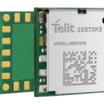
Telit’s new SE873K5 multi-constellation GNSS receiver is the smallest form factor in the company’s SE873 family of modules. Featuring the latest generation chipset and advanced power modes, it can be used in a variety of applications including wearables, fleet tracking and drones.
By Inside GNSS
u-blox recently introduced the u-blox XPLR-IOT-1 IoT explorer kit, an all-in-one package developed to evaluate and validate IoT applications.
By Inside GNSS
Persistent Systems recently introduced the Multi-Band Tracking Antenna with the goal of improving ground-based communication and tracking of friendly manned and unmanned aircraft, even in GPS-denied environments, helping warfighters defend against the threat of electronic warfare (EW) from near-peer adversaries.
By Renee Knight
ANELLO Photonics, the company behind the SiPhOGTM gyroscope, has released an Optical Gyroscope & GNSS/INS Evaluation Kit (EVK) for autonomous applications.
By Inside GNSS
At the Joint Navigation Conference in San Diego, BAE Systems unveiled its newest advanced M-Code GPS receiver for guided weapons and other small applications, enabling precise geolocation and strike capabilities in highly contested battlespaces.
By Inside GNSS
BAE Systems expanded the capabilities of its Digital GPS Anti-Jam Receiver (DIGAR) by enabling beamforming with Trimble receivers in addition to its own receivers.
By Inside GNSS
Fixposition, a positioning solution provider, recently launched Vision-RTK2, a new generation of positioning sensors powered by deep sensor fusion technology that’s an upgraded version of the original Vision-RTK.
By Inside GNSS![Trimble_BD9250_right v03[17]](https://insidegnss.com/wp-content/uploads/2022/05/Trimble_BD9250_right-v0317-150x150.jpg)
Trimble introduced today the Trimble® BD9250, a dual-frequency OEM GNSS receiver module that supports Trimble RTX® correction services. The receiver is designed to deliver high-accuracy positioning for a range of high volume, autonomous-ready applications used in the agriculture, construction, robotics and logistics industries worldwide.
By Inside GNSS
Leveraging Orolia’s HATI core in combination with Arista MetaWatch, the integration provides sub-nanosecond timestamping with accurate, precise and reliable timing
By Inside GNSS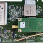
Orolia is providing Atomic Reference Time (ART) Cards in a collaborative partnership with Meta.
By Inside GNSS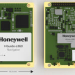
Honeywell recently introduced three new navigation systems: the HGuide o360 inertial/global navigation system (INS/GNSS) navigator, the HGuide n500 inertial navigator and the HGuide g080 GNSS receiver.
By Inside GNSS
The recently released GNS3 GNSS receiver from Juniper Systems is a scalable platform that allows users to collect real-time GNSS data with sub-meter, sub-foot and decimeter accuracy options. Users can purchase a receiver that meets current accuracy needs, with the option to increase the level of accuracy through subscriptions when needed.
By Inside GNSS