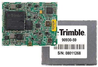
Survey and Mapping Archives - Page 16 of 27 - Inside GNSS - Global Navigation Satellite Systems Engineering, Policy, and Design

Survey and Mapping

[uam_ad id="183541"]

Markets and Multi-Frequency GNSS

FIGURE 1: Proposal to have a single chip GNSS receiver with additional pins to allow for the inclusion of an additional radio

Q: What will limit the spread of multi-frequency GNSS receivers into the mass market?

A: To set the scene, we need to define our terms of reference. By multi-frequency we mean receivers that operate with navigation signals in more than just the standard upper L-band from about 1560–1610 MHz where we find GPS L1, Galileo E1, Compass B1, and GLONASS L1. The obvious additional frequency is the lower L-band, from about 1170 to 1300 MHz, where again the same four constellations have signals.

Read More >

By Inside GNSS
[uam_ad id="183541"]
January 16, 2013

NovAtel Announces New BeiDou Capability for Its GNSS Products

NovAtel has announced support for the BeiDou Navigation Satellite System on its OEM6 family and selected OEMStar GNSS receivers.

The long-anticipated BeiDou Interface Control Document (ICD) release is a
significant milestone that facilitates global acceptance of the Chinese
GNSS system into the growing range of satellite-based positioning
applications, the company says.

Read More >

By Inside GNSS
December 18, 2012

Civil Galileo System Poses New Options for Secure Services

Conceptual design of ULTRA (ultra low-cost PRS receiver)

When European leaders first took up the idea of creating their own GNSS system nearly 20 years ago, they held up the concept of civilian control as a crucial differentiator from existing services operated by national military establishments.

As Galileo nears its operational phase, that principle may manifest itself in a surprising form: the opportunity to offer a range of security-oriented positioning and timing solutions in place of the all-or-nothing alternatives on encrypted services maintained by defense agencies.

Read More >

By Inside GNSS
November 17, 2012

2013 Asia Oceania Regional Workshop on GNSS

This free workshop on GNSS will take place at the Berjaya Times Square Hotel in Kuala Lumpur, Malaysia on December 8, 9 and 10, 2012.
Registration is limited to the first 100 people. The deadline for registration and abstract submission is November 22.

This is the fourth Asia Oceania Regional Workshop on GNSS. It is organized by Multi-GNSS Asia (MGA), whose aim is to promote GNSS interoperability, development, use and applications in the region.

Read More >

By Inside GNSS
November 2, 2012

Trimble Reports Half-Billion in Q3 Revenue

Trimble on Thursday (November 1, 2012) announced third-quarter revenue of $504.8 million, up 21 percent as compared to the third quarter (Q3) of 2011.

GAAP operating income for the third quarter of 2012 was $63.5 million, up 96 percent from the year-earlier period. GAAP net income for Q3 2012 was $53.4 million, up 91 percent from Q3 2011. Diluted earnings per share in the third quarter of 2012 were $0.42 as compared to diluted earnings per share of $0.22 a year ago.

Read More >

By Inside GNSS
October 12, 2012

Trimble Introduces Next Generation GNSS Survey, Datalink, Mapping Solutions

Trimble R10 rover

Trimble has introduced its next-generation GNSS surveying solution — the Trimble R10, a small, lightweight receiver that introduces new features and technologies, including Trimble HD-GNSS, Trimble SurePoint, Trimble 360, and Trimble xFill, to provide increased productivity.

Announced at the Intergeo 2012 conference in Hannover, Germany, this week, introduction of the Trimble R10 was accompanied by new versions of its field and office software — Trimble Access 2012.20 and Trimble Business Center 2.80 to extend Trimble’s Connected Site survey solution.

Read More >

By Inside GNSS
1 14 15 16 17 18 27
IGM_e-news_subscribe