Roads and Highways Archives - Page 9 of 17 - Inside GNSS - Global Navigation Satellite Systems Engineering, Policy, and Design

Roads and Highways

February 4, 2016

New u-blox M8 Firmware Now Supports Galileo, Increases GNSS Signal Acquisition Sensitivity and Security

u-blox modules

Thalwil, Switzerland–based u-blox has announced the upcoming release of a new firmware, FW 3.01, for its u-blox M8 multi-GNSS platform.

u-blox M8 FW 3.01 will now also support Galileo in addition to GPS, GLONASS, BeiDou. It can track up to three constellations concurrently and makes use of all satellite-based augmentation system (SBAS) signals and Japan’s Quasi-Zenith Satellite System (QZSS) at the same time, according to the company.

Read More >

By Inside GNSS
January 18, 2016

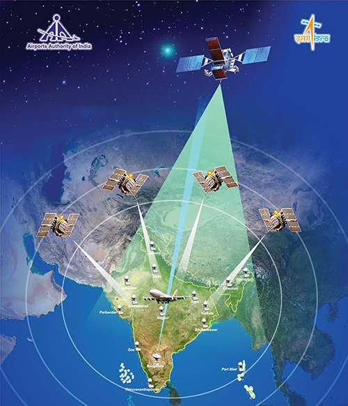
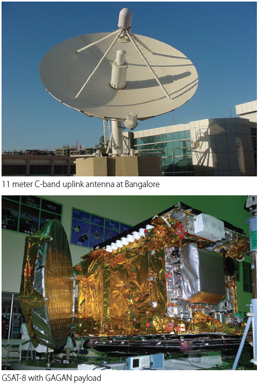
GAGAN — India’s SBAS

The GPS Aided Geo Augmented Navigation (GAGAN) system was developed by the Indian Space Research Organization (ISRO), together with Airports Authority of India (AAI), to deploy and certify an operational satellite-based augmentation system (SBAS). The system’s service area covers the Indian Flight Information Region (FIR), with the capability of expanding to neighboring FIRs. 

Read More >

By Inside GNSS
[uam_ad id="183541"]
November 30, 2015

Broad Support for GNSS-Based Transportation Tech in New Highway Bill

The House and Senate, now working with a fresh extension, have until December 4 to hammer out the details of a new highway bill. The legislation will authorize — but not necessarily appropriate — Highway Fund monies for state roadways for as long as six years and likely spin up research into intelligent transportation systems (ITS) and connected and autonomous vehicle technology — three sectors that rely on GNSS for success.

Read More >

By Inside GNSS
November 19, 2015

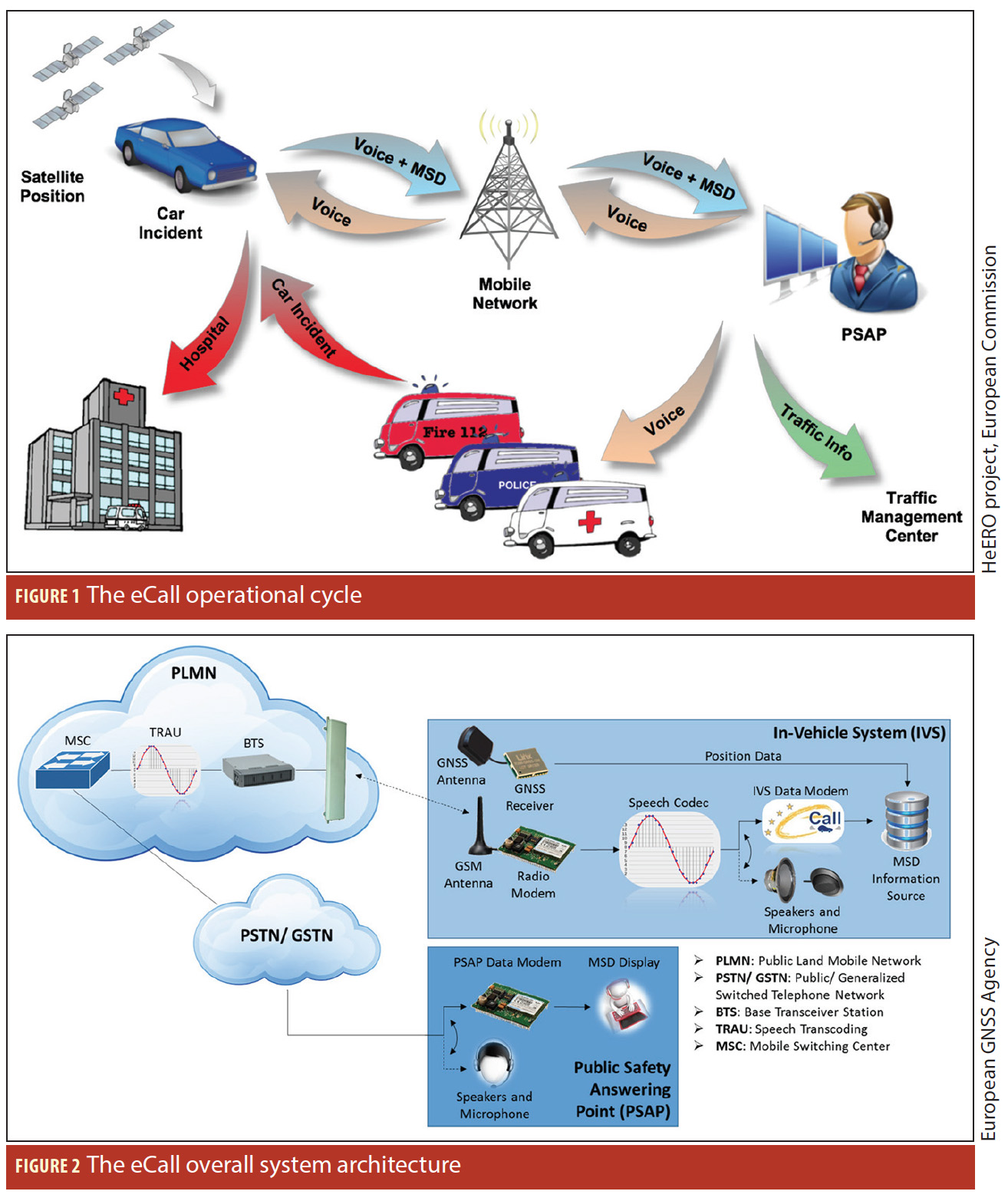
eCall

Figures 1 & 2

On April 28, 2015, the European Parliament voted in favor of an eCall regulation, which requires all new models of passenger cars and light vans that will be certified for the European market to be equipped with the automated emergency-call technology beginning in April 2018. The measure applies to all such vehicles regardless of selling price. In the future, a similar service may be implemented for trucks as well.

Read More >

By Inside GNSS
October 11, 2015

Can Galileo ‘Explode’ the GNSS Applications of Intelligent Transportation?

Some 15 years ago, Bob Denaro predicted the disappearance of GPS into its various applications.

That prediction by the former Trimble/Motorola/Navteq executive has largely been validated. Although GPS has survived in the popular consciousness as a global brand, connoting an almost magical source of location and tracking, general recognition and understanding of GNSS as a core technology within products and services has, indeed, remained murky.

Read More >

By Inside GNSS
[uam_ad id="183541"]
September 30, 2015

GNSS Stars in ITS World Congress

GNSS technology, which has been in the background of many intelligent transport system (ITS) projects and programs, will be front and center at the ITS World Congress 2015 next week (October 5-9, 2015) in Bordeaux, France.

Under the theme, “Towards Intelligent Mobility — Better Use of Space,” the event will draw thousands of registered attendees and around 200 exhibitors to take part in technical sessions, panel discussions, and demonstrations of ITS technology, products, and servuces.

Read More >

By Inside GNSS
August 17, 2015

Ultra-wideband Re-emerges as a GNSS Interference Issue

The Federal Communications Commission (FCC) is weighing a request to waive spectrum rules for a new ultra-wideband (UWB) device that would operate across a wide swath of frequencies including those used by satellite navigation. The proposal has prompted a call for a wider reconsideration of ultra-wideband limits, a suggestion opposed by the GPS community.

Read More >

By Inside GNSS
July 20, 2015

GNSS Hotspots | July 2015

One of 12 magnetograms recorded at Greenwich Observatory during the Great Geomagnetic Storm of 1859
1996 soccer game in the Midwest, (Rick Dikeman image)
Nouméa ground station after the flood
A pencil and a coffee cup show the size of NASA’s teeny tiny PhoneSat
Bonus Hotspot: Naro Tartaruga AUV
Pacific lamprey spawning (photo by Jeremy Monroe, Fresh Waters Illustrated)
“Return of the Bucentaurn to the Molo on Ascension Day”, by (Giovanni Antonio Canal) Canaletto
The U.S. Naval Observatory Alternate Master Clock at 2nd Space Operations Squadron, Schriever AFB in Colorado. This photo was taken in January, 2006 during the addition of a leap second. The USNO master clocks control GPS timing. They are accurate to within one second every 20 million years (Satellites are so picky! Humans, on the other hand, just want to know if we’re too late for lunch) USAF photo by A1C Jason Ridder.
Detail of Compass/ BeiDou2 system diagram
Hotspot 6: Beluga A300 600ST

1. RUM DEAL
Moscow, Russia, and Havana, Cuba

Read More >

By Inside GNSS
June 16, 2015

GNSS-Aided Autonomous Trucks Could Save Fuel, Reduce Congestion

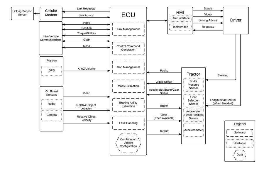
Block diagram of driver-assisted truck platooning (DATP) system. From “Heavy Truck Cooperative Adaptive Cruise Control” Phase 1 report

Although media coverage of autonomous or self-driving vehicles has focused on their use by private car owners, an initial report on driver-assistive truck platooning (DATP) highlights the prospects for their use in the commercial freight sector.

Titled “Heavy Truck Cooperative Adaptive Cruise Control — Evaluation, Testing, and Stakeholder Engagement for Near Term Deployment: Phase One Final Report,” the DATP project was funded by a grant from the U.S. Department of Transportation’s Exploratory Advanced Research program.

Read More >

By Inside GNSS
1 7 8 9 10 11 17
IGM_e-news_subscribe