February 17, 2022
New OEM Heading and Positioning Board Upgrades to Multi-Frequency GNSS
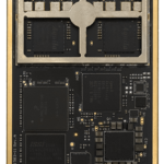
Hemisphere GNSS’s new Vega 34 OEM heading and positioning board enables users to upgrade to multi-frequency GNSS without changing pinouts. Integrators who use predecessor Hemisphere 34-pin products such as Crescent Vector H220 and Phantom 34 OEM boards can now transition to improved positioning performance and satellite tracking capabilities of the Vega series.
By Inside GNSS