December 4, 2019
Live Tests Show Confidence in Driverless Car
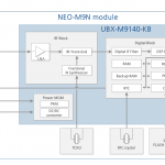
An innovative positioning engine based on a safety-oriented paradigm uses a dual-frequency GNSS receiver, automotive cameras, accurate maps, low-cost inertial sensors and vehicle odometry. The real-time integrity layer bounds the error of each estimated value with a confidence level for safe navigation.
By Inside GNSS