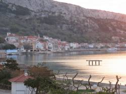
Marine Archives - Page 10 of 10 - Inside GNSS - Global Navigation Satellite Systems Engineering, Policy, and Design

Marine

September 24, 2014

Kingfisher

Eugenia Acosta, an intern with Clearpath Robotics, unloads a Kingfisher unmanned vessel in preparation for a mission (top photo), the Kingfisher components and controller (bottom photo).

“Our products are robotic research platforms,” says Clearpath’s Meghan Hennessey. “These can be configured and programmed so that our customers can explore their particular areas of interest without all the cost and troubleshooting involved in actually building robots themselves.”

Hennessey says Clearpath platforms — which include the all-terrain Husky, the larger, tractor-like Grizzly and the waterborne Kingfisher — can be thought of as project kits.

Read More >

By Inside GNSS
January 6, 2014

Enhanced Differential Loran Maritime Trials in The Netherlands Declared Successful

The eDLoran receiver including antenna is mounted in a standard enclosure (14x14x10cm) for GPS-RTK equipment provided by AD Navigation (Norway)

The Dutch Pilots Corporation and Reelektronika announced today (January 7, 2014) the successful development and test of an Enhanced Differential Loran (eDLoran) backup to GNSS in The Netherlands.

Trials at sea and in the Rotterdam Europort harbor area met the requirement for absolute accuracies in the five-meter range, according to Durk van Willigen, CEO of Reelektronika, and Wim van Buuren, Loodswezen’s information & communications technology (ICT) and innovation manager and board member.

Read More >

By Inside GNSS
[uam_ad id="183541"]
November 12, 2012

Royal Institute of Navigation NAV Series: Maritime

One in a series of NAV conferences sponsored by the Royal Institute of Navigation, this all-day event on February 21, 2013 will take place at Southampton Solent University Conference Center.

NAV-Maritime will focus on:
• Is ECDIS letting us down?
• The role of integrated navigation systems (INS) within e-navigation 
• The increasing interest in unmanned vessels

Read More >

By Inside GNSS
November 15, 2009

CERGAL 2010

The 2010 International Symposium on Certification of GNSS Systems and Services (CERGAL) will take place from April 28-29, 2010 in Rostock, on the Baltic Sea in the north of Germany.

The event includes a technical program and an industry exhibition.

Read More >

By Inside GNSS
October 27, 2009

CERGAL 2010, GNSS Certification Symposium, Issues Call for Papers

The 2010 CERGAL symposium will take place in the Baltic city of Rostock, in northern Germany, next April 28-29.

This year, the Symposium on Certification of GNSS Systems and Services will concentrate on maritime and inland waterways applications and GNSS testing infrastructure.

In addition to those topics, papers are invited on GNSS system aspects and aviation, road, rail and other special applications. Abstracts are due on November 30, 2009. 

Read More >

By Inside GNSS
[uam_ad id="183541"]
April 10, 2009

Air Force Secures ITU Filing with GPS L5 Signal Transmission

Time Series and Power Spectrum of the L5 Demonstration Signal

The GPS IIR-20(M) satellite successfully transmitted for the first time a GPS signal in the L5 frequency band today (April 10), according to the U.S. Air Force operators of the Global Positioning System. L5, the third civil GPS signal, will eventually support safety-of-life applications for aviation and provide improved availability and accuracy to users.

Read More >

By Inside GNSS
January 13, 2009

What about GPS jamming and maritime safety, and linear carrier phase combinations?

Q: What is the effect of GPS jamming on maritime safety?

A: Although GPS jamming incidents are relatively rare they can occur; and when they do, their impact can be severe.

The General Lighthouse Authorities of the United Kingdom and Ireland (GLAs) comprise the Commissioners of Irish Lights, the Commissioners of Northern Lighthouses and Trinity House, who between them provide aids to navigation (AtoNs) for the benefit of all mariners in British and Irish waters.

In order to investigate the effects of GPS jamming, whether by intentional or accidental means, the GLAs conducted a trial in 2008 on the effect of GPS denial on marine aids-to-navigation, and ship-borne and shore-based navigation and information systems.

Today’s mariners commonly use GPS enabled devices to navigate their vessels, however large, from port to port and berth to berth.  The International Maritime Organization (IMO) mandates the carriage of electronic position-fixing systems by all vessels over 300 gross tons and those carrying passengers on an international voyage in accordance with the Safety of Life at Sea (SOLAS) convention.

The GPS position is often fed into other vessel systems, for example an electronic chart display and information system (ECDIS), the vessel’s automatic identification system (AIS), or a plotter.

The use of differential GPS (DGPS) is preferred; mariners improve their positioning accuracy and ensure integrity of their GPS derived position by using the large number of DGPS radiobeacons located around the world.

Although GPS receivers for navigation are commonplace and very conspicuous on the bridge, the use of GPS is often more inconspicuous in other AtoN and positioning devices. Examples include its use for providing position input to the onboard AIS transponder, as well as the digital selective calling (DSC) system, which has the capability to include the vessel’s position as part of a distress signal.

In addition to vessel-based systems, marine aids-to-navigation use GPS. AIS timeslots may be synchronized using GPS as a source of accurate time. AIS also provides AtoN position information based on GPS input. Synchronized lights use GPS as a common timing source, and differential GPS services provide accuracy and integrity to the mariner.

Therefore, GPS denial, whether intentional from malicious jamming or unintentional due to malfunctioning equipment such as television antennas, may affect safety both on the bridge and on-shore.

(For the rest of Alan Grant and Paul Williams’ answer to this question, please download the complete article using the pdf link above.)

Q: What are linear carrier phase combinations and what are the relevant considerations?

A: Linear carrier phase combinations are formed by adding or subtracting carrier phase measurements on two or more frequencies. Such combinations are used to improve the resulting measurement in some manner relative to the original measurements.

In this context, “improvement” usually implies removing/reducing certain errors so as to facilitate the ambiguity resolution process or increase the measurement (and, therefore, position) precision. We must note, however, that improvement in both areas is not possible and thus a design trade-off is required.

In this “solution,” we will discuss how linear carrier phase combinations are formed and the key considerations associated with this process. A discussion of some of the common GPS combinations is also provided.

Topics in the full article include Linear Combinations, Integer Nature of the Ambiguities, Magnitude of Errors in Units of Cycles, Magnitude of Errors in Units of Length.

Summary and Outlook
The analysis focuses on dual-frequency combinations. However, with the modernization of GPS and the upcoming launches of Galileo and Compass, multiple frequency combinations will be possible. Despite this, the considerations discussed in this article will still hold and can be used as a stepping stone for more advanced combinations and subsequent data processing.

(For the rest of Mark Petovello’s answer to this question, please download the complete article using the pdf link above.)

By Inside GNSS
April 7, 2008

GNSS Hotspots | April 2008

One of 12 magnetograms recorded at Greenwich Observatory during the Great Geomagnetic Storm of 1859
1996 soccer game in the Midwest, (Rick Dikeman image)
Nouméa ground station after the flood
A pencil and a coffee cup show the size of NASA’s teeny tiny PhoneSat
Bonus Hotspot: Naro Tartaruga AUV
Pacific lamprey spawning (photo by Jeremy Monroe, Fresh Waters Illustrated)
“Return of the Bucentaurn to the Molo on Ascension Day”, by (Giovanni Antonio Canal) Canaletto
The U.S. Naval Observatory Alternate Master Clock at 2nd Space Operations Squadron, Schriever AFB in Colorado. This photo was taken in January, 2006 during the addition of a leap second. The USNO master clocks control GPS timing. They are accurate to within one second every 20 million years (Satellites are so picky! Humans, on the other hand, just want to know if we’re too late for lunch) USAF photo by A1C Jason Ridder.
Detail of Compass/ BeiDou2 system diagram
Hotspot 6: Beluga A300 600ST

1. FOLLOW THAT PIZZA!
Huntsville, Alabama
√ Eleven Papa John’s pizza stores in Huntsville, Alabama equip their delivery drivers with handheld PNDs and use a mapping engine developed by startup company TrackMyPizza to give customers 15 second online updates on their pizza pie. You don’t even need to leave your laptop to look out the window.

Read More >

By Alan Cameron
April 4, 2008

DoT Rescues NDGPS Project

The Nationwide Differential Global Positioning System (NDGPS) program has been salvaged from the political limbo in which it has resided for more than a year.

Following completion of an assessment by the U.S. Department of Transportation (DoT), the agency has decided to continue full NDGPS operations. Currently, 86 stations are operating with support from three federal agencies: the U.S. Coast Guard (USCG, 39 sites), the Army Corps of Engineers (9 site), and the DoT (38 sites operated and maintained by the USCG under contract).

Read More >

By Glen Gibbons
January 1, 2007

Rescue Mission: GPS Applications in an Airborne Maritime Surveillance System

Maritime search and rescue (SAR) operations do not fit the usual and customary operational modes for aircraft operations. Consequently, neither do their navigation and flight management system (FMS) requirements.

Maritime search and rescue (SAR) operations do not fit the usual and customary operational modes for aircraft operations. Consequently, neither do their navigation and flight management system (FMS) requirements.

SAR missisions are not based on schedules but rather on ad hoc events and flights. Once the mission control center receives word of an accident (ship disaster, aircraft crash, etc.), an aircraft receives a mission order and begins a high-speed ferry flight to the area of concern. After arrival in the area of the incident, the aircraft typically performs a low-altitude (500 to 1,500 feet), low-speed search flight to locate survivors and the vessel.

In executing this search, the crew employs a suite of surveillance radars, electro-optical sensor, and scanning and direction finding equipment to localize  transmissions of emergency beacons that may have been activated during the accident. Once the target (person, ship, aircraft) is found, the crew drops needed equipment, such as life rafts or pumps, out of the aircraft.

The target position and other details are reported to the mission control center in order to initiate further rescue activities. All of these activities require precise navigation and sensor control, which may be obtained by a number of GNSS/GPS applications on board the aircraft.

This article describes an airborne surveillance system, AeroMission, developed by Aerodata AG, and the GPS/inertial navigation system (INS) that supports its operation.

In addition to SAR missions, AeroMission is also suitable for maritime surveillance, border and anti-smuggling patrols, pollution detection and mapping, fishery control, offshore oil field monitoring, and research applications.

System Overview
AeroMission has been developed to provide high reliability, redundancy, and efficiency. It was designed using modular architecture and state of the art technology.

In supporting AeroMission, an integrated GPS/IMU navigation system — AeroNav — combines the GPS advantages of long-term stability and absolute accuracy with those of inertial navigation — short-term accuracy during phases of high dynamics in which GPS positioning may be lost or degraded.

A separate GPS/INS system also provides attitude reference by using strapdown algorithms providing position and velocity solutions. Turn rates and accelerations given by the IMU are corrected by the GPS pseudorange measurements. These corrections are calculated by a Kalman filter.

The basic system components include:
•    surveillance radar (using the separate GPS-supported INS)
•    forward-looking infrared (FLIR) sensor (using GPS services provided through AeroNav)
•    infrared/ultraviolet (IR/UV) scanner (using a dedicated GPS-supported INS)
•    Mission management and guidance system (using GPS services through AeroNav)
•    SAR Homing Device
•    HF, VHF, UHF, and satellite communication
•    Intercom including communication relay
•    Photo/video camera
•    Ergonomic operator work stations

Other sensors such as side-looking airborne radar or microwave radiometer can be integrated as options into the suite.

. . .

Sensor Suite
In addition to the navigation system, moving map display, system software, and databases, AeroMission incorporates a number of additional sensors to aid its surveillance and reporting functions.

  • Surveillance Radar . . .
  • Electro-optical/infrared sensor . . .
  • AIS and direction finding . . .

. . .

Mission Management
TheAeroMission management suite is an integrated solution that consists of equipment and software for sensor operation and control; sensor data gathering, storage, and evaluation; mission reporting, and communications control and recording.

. . .

Flight Deck Interface
The mission system has a number of interfaces to the flight deck in order to support the mission and decrease the work load of both the cabin crew and the flight deck crew.

. . .

System Qualification and Certification
The qualification and certification process for the project was quite challenging. All modifications of the airframe have been certified through a Supplemental Type Certificate (STC) approved by European Aviation Safety Agency.

. . .

Operational Experiences
During the test flights and also during the first 10 months of operations, AeroMission installed in a DO 328 aircraft has demonstrated its reliability and efficiency with an overall service availability of more than 99 percent . . .

For the complete story, including figures, graphs, and images, please download the PDF of the article, above.

By
1 8 9 10
IGM_e-news_subscribe