April 25, 2009
 One of 12 magnetograms recorded at Greenwich Observatory during the Great Geomagnetic Storm of 1859
 1996 soccer game in the Midwest, (Rick Dikeman image)
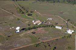
 Nouméa ground station after the flood
 A pencil and a coffee cup show the size of NASA’s teeny tiny PhoneSat
 Bonus Hotspot: Naro Tartaruga AUV
 Pacific lamprey spawning (photo by Jeremy Monroe, Fresh Waters Illustrated)
 “Return of the Bucentaurn to the Molo on Ascension Day”, by (Giovanni Antonio Canal) Canaletto
 The U.S. Naval Observatory Alternate Master Clock at 2nd Space Operations Squadron, Schriever AFB in Colorado. This photo was taken in January, 2006 during the addition of a leap second. The USNO master clocks control GPS timing. They are accurate to within one second every 20 million years (Satellites are so picky! Humans, on the other hand, just want to know if we’re too late for lunch) USAF photo by A1C Jason Ridder.
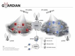
  Detail of Compass/ BeiDou2 system diagram
 Hotspot 6: Beluga A300 600ST
1. LAYING DOWN THE LAW
Albany, New York;
Madison, Wisconsin
√ In May, the New York Court of Appeals ruled 4 to 3 that warrantless GPS surveillance isn’t legal. Oregon and Washington courts agree. Meanwhile, a Wisconsin appeals court panel ok’d secret police use of a GPS tracking device, because it didn’t involve search or seizure. Wonder when the Feds will chime in…
2. BACKUP
Washington, DC
√ The land-based radio navigation system, Loran-C and its eLoran modernization, has been cut from the 2010 federal budget. Key members of the Senate’s Homeland Security and Science and Transportation committees — worried about the GAO’s report on a faltering GPS — question killing an interoperable but independent PNT backup.
3. GNSS FOR AFRICA
Trieste, Italy
√ 50 scientists from 15 sub-Saharan universities consulted with GNSS experts — and even built LEGO Mindstorm robots — at the first Satellite Navigation and Technology for Africa workshop in April. Why? GNSS infrastructure means better maps, safer transportation, managed natural resources and food supplies, improved emergency services — major goals on the continent.
4. PAY TO PLAY
Moscow, Russia
√ The head of Roscosmos, Russia’s space agency, has asked the government to make it prohibitively expensive to import cars that can’t use GLONASS. Business newspaper Vedomosti said not many Russian cars have built-in navigation systems now, and only 10,000 of nearly two million imports can use the Russian GNSS.
5. READY TO GO?
Thiruvananthapuram, India
√ In just three years, says the director of the Vikram Sarabhai Space Centre (VSSC), India’s Regional Navigation Satellite System (IRNSS) will be up and running, delivering 10 meter accuracy to the subcontinent using three GEOs and four IGSO satellites. Could be the precursor to a full-fledged Indian GNSS.
6. L5: A MIXED BAG
Middle Earth Orbit
√ The GPS satellite carrying the new “safety-of-life” civil signal is under investigation. An L5 signal transmitted on April 10 was healthy. But signals on the L1 frequency are not meeting spec. Larger than expected pseudorange errors, says the GPS Wing’s chief engineer. The L5 signal itself could be a cause.
By Alan Cameron