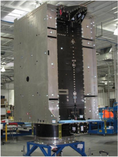
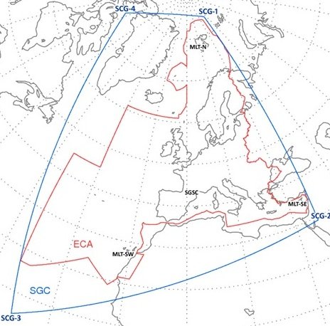
A: System Categories

July 30, 2014

Galileo Team Reports Successful Tracking of Encrypted Commercial Service Signals

The European GNSS Agency (GSA) announced today (July 29, 2014) that a recent 10-day test has successfully tracked and demodulated data from encrypted signals of the Commercial Service (CS) from available Galileo satellites.

Using receivers located in Tres Cantos, Spain, and Poing, Germany, the Early Proof of Concept (EPOC) team tracked encrypted Galileo E6-B and E6-C signals. Non-encrypted E6-B and E6-C signals have previously been tracked.

Read More >

By Inside GNSS
July 27, 2014

The Next Big Mac

Here’s the coolest “technology-meets-ingenuity-meets-sustainable-economics” story that I’ve heard in a long time: the International Sun-Earth Explorer-3 (ISEE-3) Reboot Project, a crowd-funded rescue mission to repurpose a 36-year-old NASA spacecraft.

Read More >

By Dee Ann Divis
July 24, 2014

GNSS Hotspots | July 2014

One of 12 magnetograms recorded at Greenwich Observatory during the Great Geomagnetic Storm of 1859
1996 soccer game in the Midwest, (Rick Dikeman image)
Nouméa ground station after the flood
A pencil and a coffee cup show the size of NASA’s teeny tiny PhoneSat
Bonus Hotspot: Naro Tartaruga AUV
Pacific lamprey spawning (photo by Jeremy Monroe, Fresh Waters Illustrated)
“Return of the Bucentaurn to the Molo on Ascension Day”, by (Giovanni Antonio Canal) Canaletto
The U.S. Naval Observatory Alternate Master Clock at 2nd Space Operations Squadron, Schriever AFB in Colorado. This photo was taken in January, 2006 during the addition of a leap second. The USNO master clocks control GPS timing. They are accurate to within one second every 20 million years (Satellites are so picky! Humans, on the other hand, just want to know if we’re too late for lunch) USAF photo by A1C Jason Ridder.
Detail of Compass/ BeiDou2 system diagram
Hotspot 6: Beluga A300 600ST

1. SMART BALL
Portland, Oregon USA

√ Adidas has designed every official World Cup ball since 1970. And that’s not all! The Adidas Innovation Team in Portland, Oregon, spent 4 years on a smart soccer ball with a “six-axis MEMS accelerometer sensor package” that can detect speed, spin, strike and flight path data and whip it on over to the special GPS app on your iPhone. The app interprets the data for you, coaches you, and keeps a video to show your friends. On sale now for only $299.

Read More >

By Inside GNSS
[uam_ad id="183541"]
July 21, 2014

GNSS & Geohazards

Ken Hudnut, U.S. Geological Survey

For at least two decades, GPS experts, geodesists, and public agencies have been working together to develop high-accuracy, large-scale continuously operating GPS reference stations that provide them the capability to monitor and model crustal deformation, tectonic plate movement, and the effects of geohazards such as earthquakes and volcanic eruptions.

Now, GNSS-augmented advance warning systems are going into place that can give us a crucial margin of safety in the event of an earthquake.

And none too soon.

Read More >

By Inside GNSS

New Leaders at the GPS Helm

Washington, D.C., has a peculiarity of seasons. While most of the world marks the shifts between winter and spring, summer and autumn, the politicos on the streets of the U.S. capital count the passage of time in two-year increments.

New operatives and appointees flock to the centers of power in the early days of each administration and the opening of each Congress, then migrate to friendlier climes as congressional elections loom and the administration winds down — as it is now.

Read More >

By Dee Ann Divis

GNSS Position Estimates

Q: How do measurement errors propagate into GNSS position estimates?

A: Not surprisingly, GNSS positioning accuracy is largely dependent on the level of measurement errors induced by orbital inaccuracies, atmospheric effects, multipath, and noise. This article discusses how, specifically, these errors manifest as position errors.

Read More >

By Inside GNSS

Environmental Sensing

In the past 20 years GPS has simultaneously revolutionized both our modern infrastructure (by providing real-time navigation, mapping, and timing support) and our geodetic/surveying capabilities (by providing millimeter/centimeter-level positioning). At this point, most of the GNSS innovations we expect to see in the next decade will come from calculating positions more accurately and faster, while expanding from GPS to use of all available GNSS signals.

Read More >

By Inside GNSS
[uam_ad id="183541"]

GPS Receiver Performance On Board a LEO Satellite

Equation 1

The small satellite “Technologie-Erprobungs-Träger 1” (TET-1) is the first spacecraft developed for the German Aerospace Center (DLR) On-Orbit-Verification (OOV) program, which provides flight opportunities dedicated to testing and qualification of new technologies in space. The satellite was lifted into a low-Earth orbit (LEO) on July 22, 2012, from the launch site in Baikonur, Kazakhstan.

Read More >

By Inside GNSS

2nd EUROGI imaGIne Conference 2014

The 2nd EUROGI imaGIne Conference 2014 will be held at Messe Berlin, Berlin, Germany on October 8-9, 2014.

This year’s theme is “Geographic Information Expertise: Made in Europe”.

The key aim of the imaGIne conference is to showcase the best Europe has to offer in the GI field. The INTERGEO Fair will showcase a wide variety of GI related products and services.

Program highlights:

Read More >

By Inside GNSS

ITSC 2014: 17th International IEEE Conference on Intelligent Transportation Systems

The IEEE Conference on Intelligent Transportation Systems (ITSC 2014) will take place at the Hyatt Regency Qingdao in Qingdao, China on October 8-11, 2014.

The annual flagship conference of the IEEE Intelligent Transportation Systems Society, IEEE ITSC 2014 welcomes articles in the field of Intelligent Transportation Systems, conveying new developments in theory, analytical and numerical simulation and modeling, experimentation, advanced deployment and case studies, results of laboratory or field operational tests.

Special sessions:

Read More >

By Inside GNSS
July 20, 2014

U.S. Geological Survey Releases New National Seismic Maps

Students conduct the “drop, cover, hold on” safety procedure during an earthquake preparedness drill. Photo Credit: Jessica Robertson, USGS

Updated National Seismic Hazard Maps released by the U.S. Geological Survey (USGS) on Thursday (July 17, 2014) indicate a higher level of earthquake risk for the West Coast and some areas of the Midwest and East Coast then previously thought.

Read More >

By Inside GNSS
IGM_e-news_subscribe