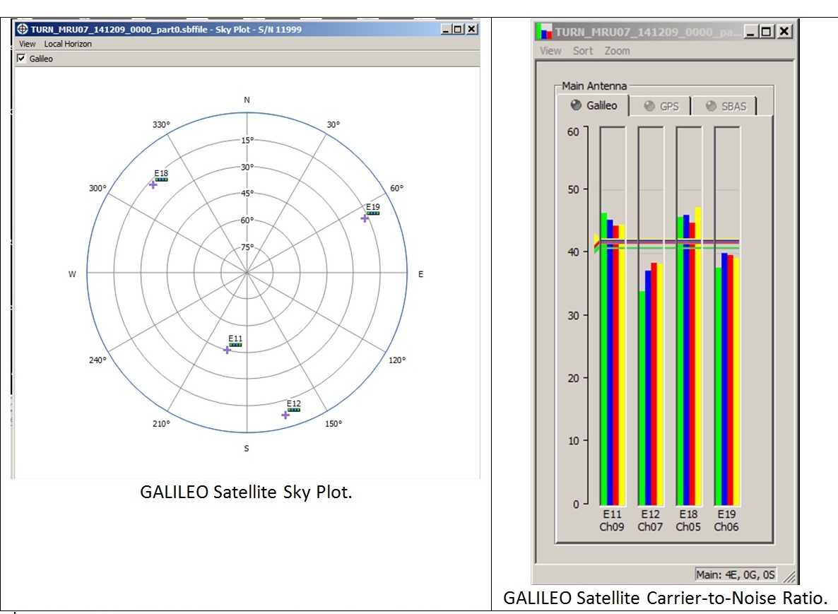
A: System Categories

November 28, 2014

Funding at Risk as Work on UAV Standards Falls Behind

Efforts to set aviation standards for larger unmanned aerial vehicles (UAVs) have fallen behind schedule, threatening essential funding for related tests and possibly complicating an Air Force program that needs the standards to make technology choices.

The schedule is slipping because initial estimates of the work involved in setting the  standards for detect-and-avoid (DAA) technology did not fully capture the complexity and extent of the effort necessary. DAA technology is intended to

Read More >

By Inside GNSS
November 23, 2014

GNSS Hotspots | November 2014

One of 12 magnetograms recorded at Greenwich Observatory during the Great Geomagnetic Storm of 1859
1996 soccer game in the Midwest, (Rick Dikeman image)
Nouméa ground station after the flood
A pencil and a coffee cup show the size of NASA’s teeny tiny PhoneSat
Bonus Hotspot: Naro Tartaruga AUV
Pacific lamprey spawning (photo by Jeremy Monroe, Fresh Waters Illustrated)
“Return of the Bucentaurn to the Molo on Ascension Day”, by (Giovanni Antonio Canal) Canaletto
The U.S. Naval Observatory Alternate Master Clock at 2nd Space Operations Squadron, Schriever AFB in Colorado. This photo was taken in January, 2006 during the addition of a leap second. The USNO master clocks control GPS timing. They are accurate to within one second every 20 million years (Satellites are so picky! Humans, on the other hand, just want to know if we’re too late for lunch) USAF photo by A1C Jason Ridder.
Detail of Compass/ BeiDou2 system diagram
Hotspot 6: Beluga A300 600ST

1. Tariffs
Beijing, China

Read More >

By Inside GNSS
[uam_ad id="183541"]

Year 10

Every so often, anthropologists — and maybe a few mathematicians — have a field day puzzling over the origins of our positional base-10 numeral system.

Oh, not the historical origins themselves, the Hindu-Arabic innovations beginning in the 5th and 6th centuries. That’s all pretty much agreed.

No, I’m referring to the possible physiological inspirations, the readily visible digits at the ends of our limbs: 10 fingers, 10 toes.

Coincidence? Does nature have coincidents, or does it abhor them like vacuums — o horror vacui?

Read More >

By Inside GNSS
November 20, 2014

RIEGL LIDAR 2015 Scheduled for Hong Kong and Guangzhou, China

RIEGL has announced that its next international user conference, RIEGL LIDAR 2015, will be held in Hong Kong and Guangzhou, China,  next May.

“To meet the growing demand of our products in China, we’ve opened a new RIEGL CHINA office just recently. To recognize this development, we will hold our next user conference in Asia. We look forward to welcoming our international and Chinese community to the spectacular cities of Hong Kong and Guangzhou!” said Johannes Riegl Jr., RIEGL Chief Marketing Officer.

Read More >

By Inside GNSS
[uam_ad id="183541"]

ING Robotic Aviation Opens New Facility

Officials at opening of ING Robotic Aviation’s new facility in Ottawa included Hon. James Moore (center), Canadian Minister of Industry, and Ian Glenn (3rd from right), ING Robotic CEO

ING Robotic Aviation officially opened the doors to its new facility in Ottawa earlier this week—representing another step forward in the company’s move into the commercial market.

The Hon. James Moore, minister of Industry Canada, officially opened the Ottawa–Orléans the new 4,000-square-foot office, which houses sales, R&D, marketing, and operations production.

Read More >

By Inside GNSS

Brian Wynne Tapped to Lead AUVSI

Brian Wynne, new AUVSI leader

The Association for Unmanned Vehicle Systems International, the world’s largest professional and industry group for those in the unmanned technology sector, has chosen a private pilot with roots in commercial transportation as its new president and chief operating officer.

Brian Wynne, currently president of the Electric Drive Transportation Association (EDTA), will be leading the organization as regulators work through the rules needed to integrate unmanned aerial systems into the national airspace and car companies build on advances in assisted-drive vehicles.

Read More >

By Inside GNSS

Using Unmanned Systems to Fight Wildfires

Image captured by an onboard Infra-red camera during the West Virginia demonstration

Large wildfires can create their own weather and a dynamic, uncertain environment, and that is one of the reasons they’re so dangerous, says Manish Kumar, an Associate Professor in the Department of Mechanical, Industrial, and Manufacturing Engineering at the University of Toledo.

Read More >

By Inside GNSS

Unmanned Innovations Top DoD Wish List

The U.S. Defense Department (DoD) is launching a search for innovative technologies to help U.S. forces to maintain their advantage in the face of gains by potential adversaries, tighter budgets, and an increasingly complex landscape of security challenges.

At the top of the agency’s wish list are advances related to unmanned systems, including miniaturization and robotics as well as systems that can operate more autonomously.

Read More >

By Inside GNSS
November 17, 2014

Europe Prepares Its Part of GNSS-Enhanced Search & Rescue Service

Cospas–Sarsat’s extension to MEOSAR (Medium Earth Orbit Search and Rescue) will extend its search and rescue coverage (the area outlined in red). On the ground the Galileo programme is contributing a Toulouse-based test bench, and a networked trio of MEOSAR ground stations – known as Local User Terminals (LUTs) – to cover Europe, based in Svalbard in the Norwegian Arctic, Cyprus and the Canary Islands. Existing LUTs are distributed on a per country basis, but it is an advantage of MEOSAR that fewer ground stations will be needed for greater coverage. Cospas-Sarsat illustration

The European Space Agency (ESA) has announced completion of tests that indicate the readiness of the European component of a modernized, GNSS satellite–aided search and rescue service known as Cospas-Sarsat.

ESA has completed construction and testing of a trio of located on three islands at the far corners of the continent, ready to pick up distress calls via satellite from across Europe and its surrounding waters.

Read More >

By Inside GNSS
IGM_e-news_subscribe