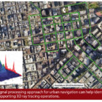
Enabling Intelligent Transportation
Topcon and Vodafone have partnered to develop a GNSS positioning service that will enable C-V2X and emerging intelligent transportation systems.
By Renee KnightTopcon and Vodafone have partnered to develop a GNSS positioning service that will enable C-V2X and emerging intelligent transportation systems.
By Renee KnightBAE Systems has enhanced anti-jam (AJ) capabilities on military weapon systems and the platforms that host them, giving both the same level of protection from interference—with such protection becoming even more critical as threats from adversaries continue to increase.
By Renee KnightESA has completed the first-ever, end-to-end testing of the Galileo system, demonstrating acquisition of an improved version of the Public Regulated Service (PRS) signal.
By Peter GutierrezAdded GNSS Resilience and Integrity Technology (GRIT) enhances VERIPOS assured positioning for marine oil and gas applications
By Inside GNSSThe European Geostationary Navigation Overlay Service (EGNOS) is Europe’s regional satellite-based augmentation system (SBAS). Used to improve the accuracy and reliability of GNSS positioning information, EGNOS is designed to provide safety of life navigation services to aviation, maritime and land-based users across the EU.
By Inside GNSSTechnology from Helix Geospace will be used to develop an accurate, resilient GNSS solution as part of the Future Flights Challenge Phase 3 project, with the goal of demonstrating how large drone swarms can be deployed to solve environmental protection concerns in GNSS-denied environments.
By Inside GNSSEurope has deployed two new Galileo satellites within its constellation, adding to the existing 26 operational satellites in orbit. The entry into service of satellites 27 and 28 follows an exhaustive 2022 testing campaign. In a recent communication, the European Space agency (ESA) said the new deployment will result in a measurable increase in positioning accuracy and improved overall performance of the Galileo system.
By Peter GutierrezValor Systems provides GNSS-based public safety and security software applications that help guide first responders to emergency scenes. The company counts local, state and federal authorities, public institutions, the military and corporations among its users.
By Peter GutierrezA new GNSS antenna array algorithm helps simultaneously estimate the antenna array attitude and direction of the incoming multipath wave fronts, improving attitude and position accuracy.
By Inside GNSSThis fall, vendors from the Defense Innovation Unit’s (DIU) Harmonious Rook prototype project will participate in DoD and international exercises. The goal is to test commercial technology developed to detect GNSS disruption.
By Inside GNSSThe new Trimble RTX Integrity monitoring system can be leveraged by the agriculture, geospatial, construction and automotive industries to ensure the correction data they’re receiving from the company’s precise point positioning (PPP) correction service, CenterPoint® RTX Fast, is accurate.
By Inside GNSS