GLONASS

September 20, 2014

Sensonor Upgrades MEMS IMU; STIM300 Featured in NovAtel, Norbit Systems

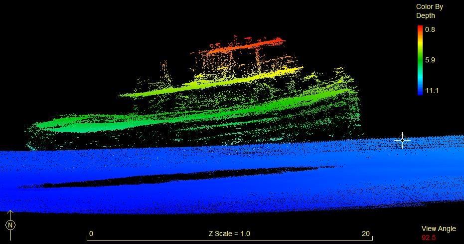
Sidescan image of Norbit Seahorse

Sensonor has announced new features for its STIM300, a small, lightweight micro-electro-mechanical system (MEMS) inertial measurement unit (IMU) that provides non-GPS–aided positioning in multiple domains.

The STIM300 — which can be used underwater, on land and sea, and in aeronautic and astronautic applications — now has real-time g-compensation in al axes and supports rates of up to 2000 degrees/second.

Read More >

By Inside GNSS

NovAtel’s Purves to Head Hexagon’s Veripos Operations

Graham Purves, new Veripos CEO

In his role as president of Hexagon Positioning Intelligence, Michael Ritter has announced the appointment Graham Purves as president & CEO of Veripos, effective September 9.

“Graham has amassed a tremendous level of experience in all aspects of our industry during his over 25 years at NovAtel,” said Ritter, who also serves as president and CEO of the Calgary, Canada–based NovAtel Inc. “This experience and especially his dexterity for sales, marketing, and business development are ideal prerequisites for this next step in his career.”

Read More >

By Inside GNSS
[uam_ad id="183541"]

NovAtel Expands Pinwheel Antenna Product Line

NovAtel GPS-702-GG-HV

NovAtel Inc. has introduced the GPS-702-GG-HV to its line of high-performance Pinwheel antennas. Tracking L1/L2 GPS and L1/L2 GLONASS frequencies, customers can use the same antenna for GPS-only or dual-constellation applications, reducing equipment costs and need for future redesign. With the same form factor and choke ring performance as the company’s other Pinwheel antennas, the GPS-702-GG-HV has been enhanced to provide the robustness needed for use under high vibration conditions.

Read More >

By Inside GNSS

Topcon Launches Two UAS Mapping Systems

Topcon Positioning Group has released two unmanned aerial systems (UAS) for mapping — the Sirius Pro and Sirius Basic.  Both systems are designed to produce accurate solutions for the automated mapping of a wide range of sites — regardless of terrain — including construction sites, mines and quarries, and for use in land surveying, power line and pipeline inspection as well as precision agriculture field mapping.

Read More >

By Inside GNSS
September 18, 2014

Falling Prices Will Spur Innovation, Competition in High-Precision GNSS Market

The high-precision GNSS industry should expect to see industry consolidation and a scramble for new markets and innovations as prices for high-end chips and modules continue to slide, experts told attendees at a ION GNSS+ panel discussion in Tampa, Florida, last week (September 11, 2014).

The falling prices could strain R&D budgets, they noted, but could also create opportunity as high-end receivers come within reach of emerging industries like self-driving cars, unmanned aerial vehicles, and are even incorporated into consumer products.

Read More >

By Inside GNSS
[uam_ad id="183541"]

SAGAIE

Scintillation — rapid RF signal frequency and amplitude changes due to signal propagation path changes and phase shifting caused by solar turbulence in the ionosphere — is well known in the GNSS community. However, conclusive scientific studies that cover the whole extent of the question are hard to find. Galileo In-Orbit Validation Experiment (GIOVE) data processing confirmed the effects of scintillation on GNSS receivers, as described in the paper by J. Giraud listed in the Additional Resources section near the end of this article.

Read More >

By Inside GNSS

Fourth International School on Satellite Navigation

The 4th International School on Satellite Navigation is underway in the GLONASS Learning Centre in Moscow, Russia. The school runs through September 24

The event is organized by Roscosmos and JSC Russian Space Systems.

Lectures and hands-on studies cover the history, current status and future of the GNSSes, particularly the use of GLONASS in the Russian economy. It includes two series of lectures and practical exercises of 36 hours each. The first covers satellite navigation and the second the combined use of Earth Remote Sensing and GNSS data.

Read More >

By Inside GNSS
September 6, 2014

Munich Satellite Navigation Summit 2015

The Antiquarium in the Residenz München

The Munich Satellite Navigation Summit will take place at the Residenz Muenchen in Munich, Germany on March 24 – 26, 2015.

Register here

The theme for this year’s summit is “Future of PNT – A Glance into the Crystal Ball”.

The technical program includes plenary discussions and updates on the main activities in worldwide satellite navigation systems, including:

Read More >

By Inside GNSS
August 22, 2014

NovAtel Introduces an IMU Option for SPAN GNSS/INS Products That Can Travel

NovAtel IMU-ISA-100C

NovAtel Inc. has announced the addition of the IMU-ISA-100C as an inertial measurement Unit (IMU) option for its SPAN GNSS+INS line of positioning products.

According to the company, the IMU-ISA-100C is a high-performance, near–navigation-grade IMU that provides a solution for platform stabilization, general purpose navigation, photogrammetry, remote sensing, and ground mobile mapping applications.

Read More >

By Inside GNSS
1 9 10 11 12 13 31
IGM_e-news_subscribe