
RTCA is working to develop new standards to tackle GNSS growth and challenges. Here’s an update on the special committee’s progress, provided during a recent webinar.
As the number of global navigation and satellite systems continues to increase, so too does the need for universal standards to ensure resilient, cybersecure and reliable navigation equipment.
A special committee (SC) of the Radio Technical Commission for Aeronautics (RTCA) has been working on developing an updated suite of dual-frequency, multi-constellation (DFMC) GNSS standards for avionics equipment with the European Organization for Civil Aviation Equipment (EUROCAE) and International Civil Aviation Organization (ICAO). Here, based on a recent RTCA webinar, “From GPS to GNSS,” we provide an update on its slow but steady progress.
Historical Standards
Let’s start with a brief review of relevant RTCA and ICAO GNSS standards to provide context for their needed updates.
RTCA
RTCA, a not-for-profit membership association and public-private partnership standards development organization founded in 1935, develops global consensus integrated performance standards on critical aviation modernization issues. It works with, among other civil aviation authorities, the Federal Aviation Administration (FAA), to develop industry-vetted and endorsed standards that can be used as means of compliance (MOCs) with FAA regulations.
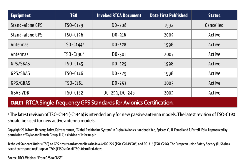
In 1985, RTCA established SC-159, Navigation Equipment using the Global Position System. Since its inception, SC-159 has produced and maintained a suite of minimum operational performance standards (MOPS) and minimum aviation system performance standards (MASPS) for aviation equipment using GPS and its augmentations: aircraft-based (ABAS), ground-based (GBAS) and satellite-based (SBAS) augmentation systems. In 1998, RTCA published its first technical standards orders (TSOs) for avionics certification of GPS/SBAS and related antennas. In 2003, it published GPS/GBAS TSOs.
These original RTCA standards have focused on a single GPS signal, the GPS coarse/acquisition (C/A) code that is modulated on the link 1 (L1) carrier frequency of 1575.42 MHz. With single-frequency, the receiver provides only decimeter-level accuracy, will not consistently produce a fixed position and risks frequent loss of signal. These standards have remained relatively unchanged over the years, even though the GNSS landscape has grown significantly more complex (Table 1).
ICAO
Thirty-five years before the establishment of RTCA’s SC-159, the ICAO Navigation System Panel (NSP) adopted Standards and Recommended Practices for Aeronautical Telecommunications. These became effective and designated as Annex 10 to the Convention on International Civil Aviation (Chicago 1944).
ICAO’s Annex 10 contains information and material for guidance in the applications of GNSS Standards and Recommended Practices (SARPs). It was not until 2001 that ICAO added GPS-related technical specifications in the SBAS and GBAS sections of GNSS requirements, through Amendment 76 to the Annex. A year later, Amendment 77 incorporated GLONASS into the Annex. Like RTCA, ICAO SARPS have thus far focused on single-frequency GPS. As with the RTCA standards, these have not been updated in decades.
New Collaborations
In 2017, RTCA signed a landmark agreement with ICAO to share standards with their respective members, for free, in the areas of communication, navigation, surveillance and air traffic management. Simultaneously, RTCA signed similar agreements with EUROCAE, SAE International (formerly named the Society of Automotive Engineers) and ARINC (Aeronautical Radio, Incorporated), to increase “the collaboration and safety of the global aviation industry,” RTCA President Margaret Jenny said.
All of these groups, with RTCA at the lead, now collectively struggle to bring their standards up-to-date to meet the challenges of today and tomorrow.
The Space Has Changed
From these initial RTCA and ICAO endeavors to codify standards for GNSS to now, several new developments have changed the game dramatically. For one, the number of GNSS constellations and ranging sources has exploded.
More Constellations
When SC-159 stood up, the landscape consisted of only seven GPS satellites. Today, core constellations consist of GPS (U.S.), GLONASS (Russia), Galileo (Europe), BeiDou (China) and QZSS (Japan). Galileo alone now includes 22 satellites. BeiDou, the largest single global satellite system, has double that. Standards have not kept pace.
Add to this complex landscape an ever-increasing number of commercial satellites. Naeem Altaf, IBM Distinguished Engineer and CTO Space Tech at IBM Space, said that within the next several years, a handful of companies such as Starlink, Telesat, OneWeb and Kuiper, plan to launch more than 20,000 satellites into space. This clutter has the potential to cause PNT signal interference.
Even More Signals
The modernization of core constellations adds to this complexity. GPS plans include adding three new civil signals (L5, L2C and L1C) on multiple frequencies. These additional end-state civil signals will be added to the legacy civil signal, L1 C/A or C.A at L1. They will be located within bands allocated for aeronautical radio navigation services (ARNS).
L5, for example, will be reserved exclusively for critical requirements for aviation safety-of-life transportation and other high-performance applications. Future aircraft will use a combination of L5 and L1 C/A. GLONASS plans to engage in similar modernization efforts. Existing standards do not account for these.
Other Realities
In addition to more satellites and signals, a few other things have changed. Interference concerns relating to adjacent-band systems have emerged. Threats, such as jamming and spoofing, have increased. Geopolitical tensions have erupted.
With regard to adjacent-band concerns, in the U.S., two years ago the Federal Communications Commission (FCC) authorized Ligado Networks to use portions of the L-band for low-power terrestrial mobile satellite services (MSS), which many say will interfere with GPS.
A Congressionally mandated review committee has completed its information-gathering but has not yet issued its final report. There remain concerns that operations close to base stations will adversely affect GPS signals in aircraft built to single frequency standards.
Natural or human-caused signal interference or tampering also remains a significant challenge. A RAND report from May 2021, Analyzing a More Resilient National Positioning, Navigation, and Timing Capability, validated that various threats could destroy, deny or trick PNT signals. These threats range from acts of war (such as the current Ukraine conflict) and extreme space weather events that could destroy space systems to PNT terrorism, computer system failures, or simple communications breakdowns. PNT backups may also be vulnerable to these and other threats, including terrestrial systems that are susceptible to physical attacks.
On the geopolitical front, some states have prohibited citizens and businesses from using constellations other than their own and/or mandated the use of their own constellations. For example, the European Parliament approved the eCall Regulation that requires all receivers in 112-based eCall in-vehicle systems to be compatible with Galileo and its SBAS, the European Geostationary Navigation Overlay Service.
All of these issues have converged to create new challenges for GNSS that RTCA and standards bodies must now address.
Charting a New Course
SC-159 leadership Co-Chairs Christopher Hegarty (The MITRE Corporation) and George Ligler (GTL Associates), the FAA’s Government Authorized Representative (GAR) Barbara Clark and Secretary Wes Googe (American Airlines) issued Terms of Reference (ToR) in June 2020. Not surprisingly, given the state of play, the committee’s specific guidance includes:
Addressing core constellations: GPS, GLONASS, Galileo and BeiDou. Incorporation of these foreign core constellations within equipment standards must be contingent upon multiple prerequisites being satisfied for operational use.
Addressing augmentations: ABAS, SBAS and GBAS.
Focusing on integrity and availability. Standards must meet integrity and availability requirements for all phases of flight.
New MOPS. These will address, to the extent practicable, the threats of intentional interference and spoofing and the possibility of higher levels of adjacent-band interference in the future operational environment.
The ToR also requires that the committee’s work be coordinated with the EUROCAE Working Groups 28 and 62 and ICAO’s NSP and that the GNSS (SBAS) L1/L5 MOPS (both versions) be developed jointly with EUROCAE WG-62.
During the presentation, all SC-159 members except Googe provided insights on their next-generation DFMC avionics workplan.
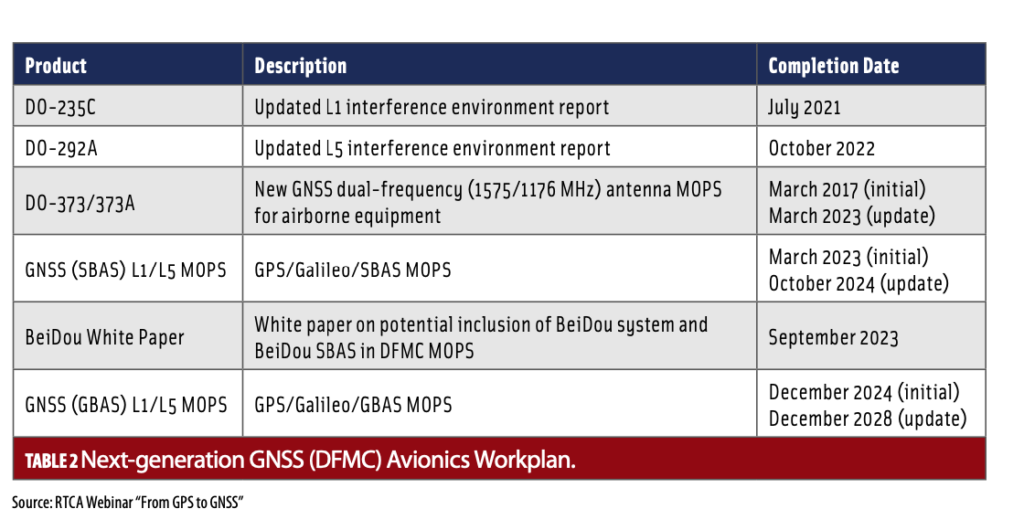
At the start, Hegarty noted that all committee timelines have slipped because of the pandemic and the fact that external multi-billion dollar external core constellation upgrade schedules have also been pushed to the right. For example, the 2001 Federal Radionavigation Plan projected 24 L5-capable GPS satellites by 2014. Today, only 17 such satellites have been launched. As a result, the updated L5 interference environment report, originally due March 2021, is now projected to be completed this October. Table 2 outlines new completion dates.
Clark, the GAR and FAA’s certification, policy and innovation lead, said the committee chose to update, rather than scrub, existing standards because it was “easier…to plug and play for constellations without going back and reimaging everything.” The Amendments to Annex 10 provided a foundation for their work. Representatives from U.S., Russia, Europe, China and Japan reviewed all of these documents and validated them in late 2020.
The team revealed they have focused on dual-frequency user equipment to address many of the challenges noted. Dual-frequency can minimize errors caused by both the ionosphere (located about 50 to 400 miles above Earth’s surface at the edge of space) and the troposphere (the lowest region of the atmosphere from the earth’s surface to a height of about 3.7–6.2 miles). These atmospheric effects can slow down and scatter GPS signals as they pass through them, altering the speed and the direction of the signal. Dual-frequencies reduce these errors and provide up to a centimeter-level accuracy more quickly.
Ligler, however, acknowledged the team’s struggle to find, as he referred to it, “a good cost-to-benefit ratio,” due to the increased costs associated with dual-use frequency equipment and infrastructure. That said, he lauded the practical benefits to users, which include greater resilience with these additional ranging sources and higher levels of accuracy at the point of receivers. “Outside of areas of SBAS coverage, the benefits will increase substantially,” Ligler said. “GNSS is highly available. But in those times where there is no particular availability, we need alternatives to support graceful degradation.” He added, “We should not mandate equipment.”
The group lamented that its requirement to update interference environment descriptions for L1 and L5 have proven to be “huge tasks” that remain in progress. One member described the process as “a constant state of negotiation and understanding,” through which they have undergone “several rounds.” Without getting into specifics, the new MOPS, they said, are going to make DFMC more resilient to these interference environments. Ligado Networks participates on their committee.
The SC-159 leaders also noted that, while ASTM is creating cybersecurity standards for aircraft to address issues such as spoofing and jamming, they are looking at signals authentication methods as part of their work. Authentication can only help with spoofing, not jamming.
In closing, the group emphasized that they seek to avoid proliferation of different definitions and different requirements. ICAO’s NSP has issued a state letter acknowledging they will adopt the final standards—whatever they ultimately look like. The goal remains to have them completed and effective by 2023.


