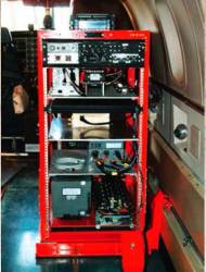
 Typical Rack-Mounted UHARS System
A next-generation “truth” reference system for the U.S. Air Force (USAF) — the Ultra High Accuracy Reference System (UHARS) — is currently under development by the 746th Test Squadron (746 TS) at Holloman Air Force Base, New Mexico.
A next-generation “truth” reference system for the U.S. Air Force (USAF) — the Ultra High Accuracy Reference System (UHARS) — is currently under development by the 746th Test Squadron (746 TS) at Holloman Air Force Base, New Mexico.
The 746 TS is the Central Inertial and GPS Test Facility (CIGTF), chartered to provide test and evaluation of guidance, navigation, and navigation warfare (NAVWAR) systems for the United States Department of Defense. The UHARS is designed to meet the increasingly accurate reference requirements for future navigation and guidance systems, providing improved position and velocity accuracies up to seven times better than the current truth system.
The CIGTF Reference System (CRS) presently serves as the truth reference system for 746th TS test activities and has provided support for a plethora of high-accuracy navigation tests over the last decade. CRS is arguably the most accurate reference system available for flight and ground testing today. However, with forecasted advances in navigation technologies on the immediate horizon, CRS will soon no longer be accurate enough to serve as truth against increasingly precise systems under test.
With these increased requirements expected in the near future, therefore, CIGTF undertook the specification, evaluation, and contracting for a next-generation truth reference. This article describes the operational requirements, design, installation, and demonstration testing of our selected system, UHARS.
Search for a New Truth
The UHARS is a rack-mounted (see inset photo, above right), tightly integrated system of navigation sensors/subsystems, data acquisition system, and a post-mission reference trajectory algorithm.
The system will provide a highly accurate reference solution for airborne and land-based test vehicles in electronic warfare environments where modernized and legacy GPS signals are jammed from friendly or hostile systems. The system must be appropriately sized and constructed for use on board multiple test-beds, including current and future test aircraft and ground vehicles.
A key subsystem of UHARS is the Non-GPS Based Positioning System (NGBPS), which is capable of providing sub-meter position accuracy in a GPS-denied (jamming) environment (see Figure 1). The 746 TS selected a commercial-off-the-shelf (COTS) system developed by the Locata Corporation to provide this NGBPS capability.
The ground-based COTS system had previously been adopted in the private sector for industrial applications in areas where GPS is unreliable — for machine control in open-cut mining, for example — or where GPS is completely unavailable, such as indoors for warehouse automation.
However, meeting the demanding 746 TS UHARS “truth reference” accuracy, range, and dynamic requirements necessitated a major upgrade of Locata’s existing commercial capability. Therefore, in 2010 the 746 TS awarded Locata a contract to improve its commercial system’s capability to meet UHARS NGBPS performance requirements.
Locata had to demonstrate the following enhanced capabilities in the NGBPS:
- much longer ranges (both for acquisition and tracking) than previously required for commercial applications
- higher power transmission levels
- new antenna designs for aircraft use
- the ability to tolerate high-rate, aircraft-style dynamic conditions.
The sidebar, “Improving on a COTS System,” describes these enhancements in greater detail.
Numerous articles and studies have been published that explain the invention, development, and real-world performance of the unique time-locked synchronization technology that is critical for recreating a GPS-like system on the ground.
The sidebar, “Time for Precise Positioning,” provides a brief overview of this technology, and more extensive discussions of the commercial NGBPS system and its applications can be found in the articles in the Additional Resources section near the end of this article.
To enable the COTS system to be used in a large wide-area aircraft-based UHARS system, Locata was contracted to deliver the following essential technical requirements:
- user equipment (rover receivers) that can acquire and track NGBPS signals at a minimum range of 30 miles (50 kilometers)
- nanosecond-level time-locked synchronization of the NGBPS network ground transceivers demonstrated at these ranges
- a demonstrated capability to transmit the NGBPS signals at higher powers via an external amplifier, while maintaining signal and synchronization integrity
- design and supply of transmitter and receiver antennas that provide adequate coverage (gain) and multipath mitigation under specified aircraft dynamics
- assured receiver tracking loop performance adequate to support aircraft flight dynamics
- development of tropospheric models that mitigate the large tropospheric errors (delay) experienced by terrestrial signals over long distances
- Assured position accuracy better than 18 centimeters (3dRMS) at these extended ranges when the position dilution of precision (PDOP) is less than 3.
The ultimate goal of the NGBPS is to achieve a standalone, receiver postprocessed positioning accuracy of 10 centimeters/axis — an extremely demanding specification for a land vehicle, let alone an aircraft traveling at more 550 kilometers per hour (kph) in the complete absence of GPS.
The Road to White Sands
Locata carried out initial research and development in late 2010 and passed the NGBPS contract preliminary design review (PDR) requirements in February 2011. To enable a clear demonstration of the enhanced NGBPS flight capabilities for the subsequent critical design review (CDR) conducted in June 2011, Locata deployed an experimental 1,500-square-kilometer NGBPS system around the Snowy Mountains Airport near Cooma in New South Wales, Australia.
A number of flight trials were flown in this network before the CDR, using a twin-engined aircraft organized by Professor Chris Rizos’ Satellite Navigation & Positioning Laboratory (SNAP Lab) within the School of Surveying & Spatial Information Systems, at the University of New South Wales (UNSW). The UNSW aircraft had been fitted-out with a Locata receiver and a complement of GPS, inertial, and other sensors that functioned as a truth reference system to compare against Locata-derived solutions.
These initial flights proved that the NGBPS performance requirements could be met in the area covered by the six sites of the Australian network, and Locata officially passed the CDR on August 19, 2011. For details of the successful CDR results, see the paper by A. Trunzo et alia in Additional Resources presented by 746th TS authors at the September 2011 ION GNSS conference in Portland, Oregon.
The preliminary Australian flight tests adequately demonstrated the enhanced NGBPS performance for the contract CDR. However, due to the limited number of sites Locata could physically access for installation of its network around the Snowy Mountains Airport, the flights were constrained to a smaller area than that required by the USAF for operational use. Further, the unpressurized UNSW aircraft could not be used to test the much higher operational altitudes and flight dynamics required by the UHARS NGBPS.
A key milestone following the successful completion of the CDR for this contract, therefore, challenged Locata to demonstrate its system on the White Sands Missile Range (WSMR) in New Mexico, USA, where the 746 TS often conducts GPS jamming tests. The demonstration was dubbed the Locata NGBPS Tech Demo.
Deploying the Tech Demo sounds simple enough in principle. However, due to weather delays, limited aircraft availability, other projects requiring access to the range, and many other issues well outside the team’s control, the White Sands Missile Range was only available for such a test during the last week of October — a mere four months after the CDR meetings. Schedule therefore became an urgent and major factor.
Nonetheless, in those short four months, the team — comprised of members from Locata Corporation, 746 TS, the Air Force Institute of Technology (AFIT), Advanced Logistics Corporation, and TMC Design Corporation — pulled together to plan and execute this crucially important test event.
Boots on the Ground
Immediately following the CDR, intense planning and coordination between team members began in earnest. In a whirlwind of activity, Tech Demo designs were reviewed and revised, components were purchased and tested, and transceiver ground stations were fabricated.
Despite the incredibly tight schedule, and overcoming what sometimes seemed insurmountable obstacles, in early October 2011 the team landed at White Sands ready to work and began the site erection process. The team had only two weeks to assemble, deploy, and perform check-out of 10 sites, with the last week of October reserved for flight testing.
The “Master” site was the first one assembled, at a location with significantly higher elevation than the other sites. Figure 2 depicts the layout of the NGBPS sites on a Google Earth image. After quite a bit of reconnaissance, analysis, and negotiation between the 746 TS, Locata, and AFIT, the exact location for the Master site was selected — at North Oscura Peak (NOP), towards the top northeastern edge of WSMR.
This high-elevation site, shown in these photographs, consisted of two transmit antennas, one high-gain dish receive antenna, and one GPS antenna, all mounted on a concrete wall approximately 20 feet high. This location provided line-of-sight to all the prospective lower-level NGBPS sites on the test range. A protective enclosure contained the transceiver, meteorological data collection equipment, amplifiers, power converters, and a prime power source that rounded out the site setup.
Once the network’s master site was established and tested, the team was ready to divide and conquer the nine remaining (slave) sites.
Setting up all of the lower elevation sites proved to be a rather arduous and time consuming task. The Tech Demo site spanned an area of approximately 45 miles by 30 miles. Roads on the White Sands Missile Range are few and far between, which necessitated long back-and-forth trips to move from one site to another.
Locata’s standard commercial system has in-built capability for control and monitoring from a remote location using a modem, and this feature was used to ease deployment and testing in the Australian experimental wide-area system. However, the time constraints imposed on the Tech Demo simply made it impossible to arrange for the requisite communications approvals on the Range — and consequently the team clocked up many, many miles over the two-week period allocated to fielding and testing.
For a system of this size, it quickly became apparent to everyone that remote control capabilities would be an essential “must-have” feature for real-world deployment!
As the Tech Demo was never meant to be a permanent installation, the 746 TS required a very portable, field-deployable system that could be easily moved if need be. The system also had to be able to run off either grid or generator power, depending on what was available at suitable geographic sites on the Range.
Locata and the 746 TS, therefore, specified a Tech Demo NGBPS transceiver “slave” configuration that could be manufactured locally, set up by one person if necessary, and transported in a pickup truck. The resultant solution incorporated portable antenna masts and a single weather-proof metal enclosure — the “box” — that contained all the necessary electronics. Each of the nine “slave” sites consisted of two tripods which supported all transmit and receive antennas (see this photo).
Figure 3 shows an inside view of the box containing a transceiver, meteorological collection equipment, amplifiers, and power converters. The meteorological sensors and probes were grouped onto a separate small mast externally connected to the box, and power was provided by the most convenient source (either prime power where available, or a gas-powered generator in other locations).
At Home on the Range
Because of the logistics and travel times involved, it took 11 working days (and sometimes nights!) to configure, set up, and check out the nine “slave” sites. During this time, the team had numerous wildlife experiences, including a rattlesnake encounter, and an epic struggle with a “possessed” rental car that had taken the driver’s keys prisoner inside the vehicle. (This particularly memorable episode in the wilds of the desert, miles from anywhere with a useless car that had all the communications equipment locked inside it, promptly led to a nearby NGBPS site being referred to thereafter as “Stranded”).
Despite these and many other challenges, the team had all 10 sites, as well as the aircraft and three “rover” receiver locations, set up and ready on time for the October 24–30, 2011, flight trials.
One important item of note is that all the ground stations had the ability to collect meteorological data; unfortunately, the specialized version of the meteorological equipment for the aircraft did not arrive in time for the tests and, hence, could not be fitted to the test aircraft, a twin-engine C-12J, the military version of the Raytheon Beech 1900C. The lack of this equipment represented a distinct setback, as the tropospheric effects of the long ranges faced in this Tech Demo posed a particular concern to the navigation specialists on the Locata NGBPS team, who were focused on delivering centimeter-accurate position solutions.
To make up in part for the lack of aircraft-based meteorological data, the USAF arranged to launch weather balloons from the north end of WSMR at the start and end of each test, to at least provide some samples of pressure, temperature, and humidity conditions aloft. This data allowed Locata to assess the meteorological models used to derive tropospheric corrections.
Down to Business
With all the setup and checkout behind us, Locata’s system was put to the test. As the U.S. Postal Service’s mantra puts it: “We’ll deliver in wind, rain, sleet, or snow” — and so did the Tech Demo team!
In the end, the tests clearly demonstrated that for a future UHARS “truth reference” system, close may be good, but to put it in the words of one of America’s legendary gunman, Wyatt Earp, “Fast is fine, but accuracy is everything.” And accuracy is what counted and was proved in this demonstration!
Tech Demo Data Collection. During the flight trials, approximately 15 hours of flight profile data were collected. The flight profiles were designed to test the performance of the Locata NGBPS system against the contract requirements. In order to achieve this, the test aircraft flew a number of different flight profiles at varying altitudes, speed, and time of day in order evaluate the performance of the Locata NGBPS system under different scenarios. Weather conditions during the flights varied from clear blue skies to heavy wind and rain, hail, and snow.
On the aircraft flights, data were logged from both the Locata receiver and the CRS pallet at a 10-hertz rate. Notably, the receiver collected measurement data that was time-aligned to the CRS data so that the effects of any aircraft motion would be insignificant when comparing solutions of the two systems.
On the ground, a high-precision GPS reference receiver logged data to allow differential GPS post-processing in the CRS navigation solution. Data from the meteorological ground sites were modulated on the Locata signals and logged at the Locata receiver on the aircraft. However, for redundancy, each meteorological station also logged data at a one-hertz rate, which could be downloaded after each flight sortie.
Following the flight trials, the Locata solution and CRS truth solution were postprocessed independently by Locata and the 746 TS personnel, respectively. Furthermore, Locata did not have access to the USAF navigation solutions until after their final Locata solutions were tendered to the Air Force for independent performance analysis.
However, to allow preliminary analysis of the system’s performance, Locata was provided with four small (approximately one-hour) samples of CRS truth solution data for initial comparison purposes. These USAF solution samples therefore did not count towards the final performance analysis undertaken by the 746 TS.
One of these CRS solution data samples supplied to Locata was collected during a flight sortie on Sunday, October 30, 2011. The comparison of the Locata and the USAF CRS-derived truth solution from this sample period is considered representative of typical NGBPS performance during the Tech Demo. We will discuss that comparison later in this article to illustrate the NGBPS performance against USAF-furnished positions.
As this issue went to press, analysis of the huge amount of data collected had just been completed by both the Air Force and Locata, and a complete final report on the Tech Demo had been submitted.
Locata NGBPS Tech Demo
By October 23, 2011, the Locata NGBPS Tech Demo network of 10 transceivers and two ground-based receivers had been deployed across the designated test area at the northern end of WSMR. Significantly, a modified antenna designed for the NGBPS test (described in Enhancement 2 in the sidebar, “Improving on a COTS System”) and a Locata receiver had by then been installed in the 746 TS’s C-12J aircraft. These joined the established GPS and inertial reference sensors normally used to provide CRS truth data for post-processed position solutions.
All systems were then confirmed as ready for use in the defined flight profiles, and USAF pilots flew a total of eight sorties in the C-12J during seven consecutive days beginning on October 24. Predefined profiles were flown each day to record data for testing and to evaluate network performance. Flight times were staggered over various periods of each day to ensure data was collected in as many different diurnal, weather, and tropospheric conditions as possible.
The weather during that week was relatively benign, except for a fierce storm (lightning and hail on the range, and snow up at the high-elevation NOP master site) in the middle of the night on October 26. Astonishingly, despite the intense weather the test pilots still calmly flew their profiles, while those of us on the ground watched in amazement and shook our heads in disbelief at the professionalism on display. Test pilots are certainly in a league of their own!
The Locata receiver installed in the C-12J’s electronics rack had internal memory, backed up by disk storage on a notebook computer, to record measurement data while in flight for later, off-line analysis. Other collected data included logs from the transceivers, weather data collected at each transmitter site and by weather balloons, plus positioning data collected by the USAF from their CRS position reference system on the aircraft.
The nanosecond-accurate, time-locked synchronization worked well for the full duration of the Tech Demo. For the actual flight tests each day, the synchronized transceiver sites were authorized to transmit only during the time frames for the tests approved by WSMR. Because of the way the synchronization technology is managed in a network, Locata could control transmission of signals over the entire NGBPS network by simply turning the Master site’s transceiver on or off.
A “slave” transceiver will not transmit if it does not receive a time-locked reference signal; so, turning on the Master site’s transceiver commenced the synchronization process and subsequent transceiver signal transmissions throughout the whole network. Upon receiving the master signal, other transceivers generally required only 30 to 60 seconds to synchronize at the nanosecond level.
Due to real-world physical visibility constraints, the NGBPS has the capability to “cascade” the synchronization reference function from the Master site through a first slave transceiver to a second slave that is unable to see the Master transceiver.
Locata successfully demonstrated this synchronization cascading capability during tests on October 28. Throughout the Tech Demo, the entire 800 square-mile (2,000 square-kilometer) network achieved nanosecond-accurate synchronization within several minutes of the Master being activated and remained time-locked, even during severe weather, until turned off at the end of each test.
Sample Positioning Results — October 30 Flight Test
At the time of writing in early April 2012, the Locata data had been fully analyzed. Locata-derived position solutions for the entire period of the Tech Demo have been supplied to the Air Force, which, however, has not yet had sufficient time to complete its analysis of the entire data set. That process involves independently comparing and corroborating Locata’s performance against USAF CRS-derived truth reference positions.
Consequently, a final report for the entire Tech Demo data set is not available at the time of writing. Nevertheless, enough data has been analyzed to give the NGBPS team confidence in the measured performance during the Tech Demo period.
A representative data set from Sunday, October 30, 2011 (Local time 10:09:18 – 10:47:30) can therefore be published here, as a typical example of the observed performance. The flight profile for this example data consists of three “Race Track” circuits at a flying height of approximately 25,000 feet above sea level and with an approximate aircraft speed of 195 knots.
Acquisition and Tracking Performance. Locata examined its receiver logs to determine when the receiver acquired the first signal with each flight, and the maximum range at which the receiver tracked a signal.
Locata’s analysis of the full data set over the period of the Tech Demo, shows that the average range for acquisition of the first signal from the network was 48.8 miles (78.5 kilometers). For this specific October 30 example, Figure 4 shows the tracking status of the first signal acquired, with green indicating when the signal is being tracked and red when it is not. Figure 3 indicates that, once the NGBPS started transmitting, the first signal on this day was acquired in 73 seconds at a range of 38.6 miles (62.2 kilometers). The maximum range at which the receiver tracked a signal was 40.9 miles (65.8 kilometers), which is well above the USAF’s 30-mile tracking requirements.
Flight Characteristics. For the example data from October 30, Figure 5 shows the racetrack pattern at 25,000 feet for three circuits flown at approximately 195 knots. The USAF solution (“Ref”) is shown in blue and the Locata code solution shown in red. The positions of the 10 transceiver sites are indicated by asterisks (*). Against the USAF reference solution, Figure 4 shows the code solution performance of the NGBPS with an overall 3dRMS difference of 0.25 meters.
Figures 6 and 7 present the aircraft roll, pitch, heading, velocity, and altitude as provided by the USAF reference solution. Importantly the attitude information allowed the USAF solution to be lever-arm corrected to the Locata receiver’s antenna.
Locata Carrier Solution Performance. The Locata 10-hertz carrier solution was postprocessed entirely independent of access to the USAF reference solution. The processing methodology used a forward and reverse extended Kalman filter (EKF), incorporating tropospheric corrections derived from available meteorological data to solve for position, velocity, acceleration, “residual” tropospheric scale factor, and signal ambiguities using geometry change.
Figure 8 shows the number of signals tracked by the receiver and used in the EKF solution along with the total number of transceiver sites available (note that each transceiver is designed to transmit four ranging signals simultaneously).
All 10 transceiver sites were used for the entire period and 35–36 signals were used in the EKF solution. Figure 9 shows the PDOP as well as component DOPs in east, north and vertical. The maximum PDOP for the flight profile is approximately 3, while the worst DOP is approximately 2.7 in the vertical component.
Figure 10 shows the difference in east, north, and height between the USAF CRS-derived reference solution and the Locata carrier solution, and Table 1 contains the respective RMS statistics. The RMS values in the east and north components are 0.06 meter, whilst the RMS in height is just over twice that of the horizontal at 0.15 meter. These values correlate with the larger DOP in the vertical component than the horizontal components. The overall and 3D positioning accuracy meets the USAF contract requirement set for NGBPS-level performance — better than 18 centimeters (3dRMS) when the position dilution of precision (PDOP) is less than 3.
Conclusion
This article has examined the development and testing of a new terrestrial Non-GPS Based Positioning System, which is the key component for the realization of the USAF’s next-generation Ultra High Accuracy Reference System performance in a GPS-denied environment. The UHARS, currently under development by the 746th Test Squadron at Holloman Air Force Base, New Mexico, will become the new “gold standard truth system” for the increasingly demanding test and evaluation of future navigation and navigation warfare systems for the U.S. Department of Defense.
Over an 18-month period, Locata enhanced their COTS technology to work in aircraft applications that covered much larger areas — and, hence, far longer ranges — than previously encountered in commercial industrial operations. Throughout the NGBPS Tech Demo conducted in October 2011, the NGBPS system synchronized flawlessly over the entire period of the trials, during which approximately 15 hours of NGBPS test data were recorded by the 746 TS for later comparison against the USAF’s current CRS truth-reference system.
Data processing has just been completed at press time, and the preliminary position analysis and data reviews seem to indicate promising results. When compared to the specifications set forth in the contract, it appears that NGBPS tracking and positioning requirements have not only been met but exceeded on many points.
Additional Resources
[1] Barnes, J. and J. LaMance, B. Lilly, I. Rogers, M, Nix, and A. Balls, “An Integrated Locata & Leica Geosystems Positioning System for Open-Cut Mining Applications,” 20th International Technical Meeting of the Satellite Division of the Institute of Navigation, Fort Worth, Texas, September 26–29, 2007
[2] Barnes, J. and C. Rizos, M. Kanli, and A. Pahwa, 2006, A positioning technology for classically difficult GNSS environments from Locata. IEEE/ION PLANS, San Diego, California, April 25–27, 2006, pp. 715-721
[3] Barnes, J. and C. Rizos, M. Kanli, A. Pahwa, D. Small, G. Voight, N. Gambale, and J. LaMance, “High Accuracy Positioning Using Locata’s Next Generation Technology,” 18th International Technical Meeting of the Satellite Division of the Institute of Navigation, Long Beach, California, September 13-16, 2005
[4] Barnes, J. and C. Rizos, M. Kanli, D. Small, G. Voight, N. Gambale, and J. LaMance, 2004b. Structural Deformation Monitoring using Locata. 1st FIG International Symposium on Engineering Surveys for Construction Works and Structural Engineering, Nottingham, UK, 28 June – 1 July 2004
[5] Barnes, J. and C. Rizos, J. Wang, D. Small, G. Voight, and N. Gambale,(2003a), “LocataNet: The Positioning Technology of the Future?” paper 49, Proceedings of the 6th International Symposium on Satellite Navigation Technology Including Mobile Positioning & Location Services (CD-ROM), Melbourne, Australia, July 22-25, 2003
[6] Barnes, J. and C. Rizos, J. Wang, D. Small, G. Voight, and N. Gambale, (2003b) LocataNet: A new positioning technology for high precision indoor and outdoor positioning,” Proceedings of the 16th International Technical Meeting of the Satellite Division of the Institute of Navigation, pp. 1119–1128, Portland, Oregan, September 9–12, 2003
[7] Barnes, J. and C. Rizos, J. Wang, D. Small, G. Voight, and N. Gambale, (2003c) High Precision Indoor and Outdoor Positioning Using LocataNet,” 2003 International Symposium on GPS/GNSS, Tokyo, Japan, November 15–18, 2003
[8] Barnes, J. and C. Rizos, J. Wang, D. Small, G. Voight, N. Gambale, J. LaMance, T. Nunan, and C. Reid, “Indoor Industrial Machine Guidance Using Locata: A Pilot Study at BlueScope Steel” 60th Annual Meeting of the Institute of Navigation, Dayton, Ohio USA, June 7–9, 2004
[9] Barnes, J. and C. Rizos, A. Pahwa, A. Politi, and J. van Cranenbroeck, 2007. “The Potential of a Ground-Based Transceiver (LocataLite) Network for Structural Monitoring of Bridges,” Proceedings of 5th International Conference on Current & Future Trends in Bridge Design, Construction & Maintenance (CD-ROM), Beijing, P.R. China, September 17-18, 2007
[10] Choudhury, M. and C. Rizos, Slow structural deformation monitoring using Locata — A trail at Tumut Pond Dam,” Journal of Applied Geodesy, 4(4), 177-187, 2010
[11] http://mining.leica-geosystems.com/products/Jassist/Jps/
[12] Rizos, C. and Y. Li, N. Politi, J. Barnes and N. Gambale, “Locata: A New Constellation for High Accuracy Outdoor and Indoor Positioning,” FIG Working Week “Bridging the Gap Between Cultures,” Marrakech, Morocco, paper 4917, May 18–22, 2011
[13] Rizos, C., and B. Lilly, C. Robertson, and N. Gambale, “Open Cut Mine Machinery Automation: Going beyond GNSS with Locata,” Proceedings of the 2nd International Future Mining Conference, Sydney, Australia, Australasian Institute of Mining & Metallurgy Publication Series 14/2011, 87-93, November 22–23, 2011
[14] Rizos, C. and G. W. Roberts, J. Barnes, and N. Gambale, “Locata: A New High Accuracy Indoor Positioning system,” Proceedings of the International Conference on Indoor Positioning & Indoor Navigation (IPIN), pp. 441-447, Mautz, R., and M. Kunz, and H. Ingensand, (eds.), Zurich, Switzerland, September 15-17, 2010
[15] Trunzo, A., and P. Benshoof, and J. Amt., “The UHARS Non-GPS Based Positioning System,” 24th International Technical Meeting of the Satellite Division of the Institute of Navigation, paper 3582, Portland, Oregon, USA, 20-23 September 20–23, 2011
NOTE: Distribution Statement A: Approved for public release. Distribution is unlimited.
PA number: 96ABW-2012-0116

