
Locata CEO Nunzio Gambale explains why fielding complementary PNT solutions is about much more than just backing up GPS, and why PNT resilience has become an ecosystem problem.
At the PNT Leadership Summit last September, Locata CEO Nunzio Gambale put a blunt question on the screen again and again: “What’s your replacement?”
He asked it over ports, offshore energy projects, precision agriculture systems and critical infrastructure sites operating in what his presentation called “red zones”—places where GNSS-dependent systems may fail, degrade or become unreliable because of jamming, spoofing or other forms of interference. Across those examples, the warning was the same: high-value civilian systems have been built around precision positioning, navigation and timing, but many still have no credible replacement when the signals they depend on are denied.
That argument has become progressively more difficult to dismiss.
Only months earlier, Gambale said, Ukraine’s June 1, 2025, Operation Spider Web demonstrated how low-cost, precisely coordinated stealth drone attacks could reach strategic targets far beyond the front lines. Ukraine said it used 117 drones, and the Council on Foreign Relations described the attack as evidence that low-cost precision strikes are becoming accessible to many state and non-state actors.
For Gambale, Operation Spider Web has forever changed the strategic logic of PNT. If the now ubiquitous drones can use satellite navigation to reach strategic assets, governments and operators defending those assets will have to increasingly jam, spoof or otherwise deny the signals those drones rely on. The result is a new kind of collateral damage: Civilian systems that depend on the same signals may be disrupted by the defensive measures intended to protect national infrastructure.
That was the September argument.
Since then, the jamming and spoofing environment has become more urgent, particularly around the Persian Gulf and the Strait of Hormuz. Meanwhile, in the Baltic area, Russian electronic warfare is already turning that risk into a live political and operational crisis. In May, Ukrainian officials said Russian electronic warfare had deliberately diverted Ukrainian drones into Latvian airspace, with repeated incursions culminating in explosions at an oil storage facility and contributing to the collapse of Latvia’s government. Inside GNSS+ reported that widespread GNSS interference in the Gulf and Strait of Hormuz region coincided with sharp disruption in commercial shipping, with maritime analytics providers documenting more than 1,100 vessels affected by GPS and AIS interference in a 24-hour period, including ships falsely positioned at airports, a nuclear power plant and on Iranian land.
That escalation makes Gambale’s question feel less like a conference provocation and more like an operational imperative.
The resulting challenge is more difficult than simply asking for a backup to GPS. For Gambale, that phrase is too vague to be useful. The real question is application-specific.
“This isn’t simply about backing up GPS,” Gambale said. “The point of PNT is the outcome: What the application requires, and what can still deliver it when GPS is degraded, denied or no longer trusted.”
That is the core of his argument. The world did not adopt GNSS merely as a convenience; it built entire classes of infrastructure, automation and digital systems on top of it. Now the same signal dependency that enabled enormous economic value has also become a systemic vulnerability.

The Civilian Problem Has Changed
For decades, GNSS interference was often framed as a military concern. Jamming and spoofing belonged to battlefields, contested borders and electronic warfare scenarios. Gambale believes that framing is “no longer even close to the reality.”
The drone era has changed the logic. If hostile drones use GNSS to navigate, then defending critical infrastructure absolutely demands the denial of that same signal locally. In other words, the jamming will not come only from the adversary; it will inevitably also come from the government or operator trying to protect its own critical assets.
“What’s the first thing you need to do for anti-drone systems?” Gambale said. “You need to jam the GPS, so that the enemy can’t use the same signal that you’re using. I can tell you categorically that in, say, the UAE, it’s not the U.S. or Israel or Iran that’s jamming Dubai or Abu Dhabi. It’s the UAE itself. We’ve heard credible reports that a GNSS jammer is now installed at the top of the Burj Khalifa. Think about that. It’s called ‘frequency fratricide’… and the Golden Dome, Drone Walls and many other national protection systems you see being built are now undeniable proof that ‘jam yourselves’ is the future.”
That creates what he sees as the new civilian crisis: The same denial zone meant to protect national strategic sites will inevitably disable the civilian systems built around satellite PNT.
“If you want to deny this magical capability to your enemy, you have to deny it to the areas around your critical infrastructure,” Gambale said. “However, you then jam the surveyors, you jam the harbor pilots bringing ships into port, you jam all of the autonomous systems, you jam the mobile phone technologies, you jam the timing for data centers, you jam the landing systems for aircraft. Uber Eats. Waymo. Google Maps.”

That argument is not merely a Locata argument. Gambale cites Doug Taggart, president of Overlook Systems Technologies and an ION Fellow, in the Spring 2026 ION Newsletter. Taggart argued that GPS now underpins transportation safety, economic activity, communication networks, precision agriculture and critical infrastructure, while the United States has spent more than 25 years struggling to identify a backup. Taggart’s conclusion was that resilient PNT capability should be understood as an inherently governmental responsibility, whether the physical systems are government-operated or commercially provided.
That framing shifts the debate from product or solution selection to public responsibility. The issue is not whether GPS remains essential. It does. The issue is whether critical systems can continue operating when GPS is unavailable, untrusted or locally denied.
The Port Test: What Happens When Precision Stops?
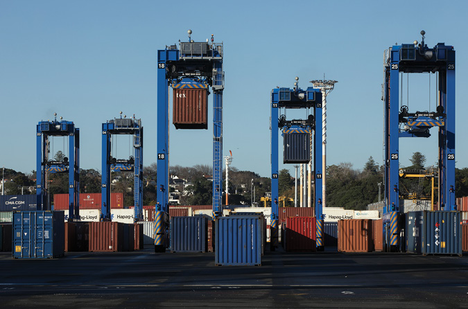
Gambale’s most concrete example, from Locata’s own experience in the jamming zones, is port automation. In his summit presentation, he used the Port of Gdańsk and major Baltic infrastructure projects to illustrate the new PNT reality. The point was not simply that ports use GNSS. It was that modern automation systems, such as in ports, logistics hubs, etc., all depend on very precise positioning—continuously and reliably.
The presentation described a $3 billion Port of Gdańsk expansion, with automation as a key part of Polish port infrastructure. It also described fully autonomous rubber-tired gantries—25 ordered, 26 meters high by 30 meters wide, $20 million each, using three RTK GNSS systems for autosteer and placement—with a requirement of less than 2 centimeters, 3 sigma, 24/7/365, without fail.
Large autonomous gantries and other automated systems do not need “some” positioning. They must have centimeter-level positioning, all day, every day. If the position solution degrades, the machine does not simply become less efficient. It stops dead.
“These machines are automated, and they’re stacking containers on top of one another autonomously, without any human in the loop,” Gambale said. “They must have two- to five-centimeter positioning, or else the entire system doesn’t work. This is not some academic argument. When an infrastructure site like Gdansk is jammed, the company literally owns $500 million dollars’ worth of ‘bricks.’ The company’s need for centimeter-level GNSS is dire. Jamming can cost millions per day. And that is a clear and existential threat to a business’ existence.”
He framed the problem in operational terms. A lower-accuracy backup may sound useful on a policy slide, but if it cannot support the application’s required precision, it does not solve the problem.
“If a ‘solution’ blows out past five centimeters, the machines must stop,” he said. “Something that gives you 2 meters of ‘GPS backup’ is of absolutely no use to that type of application.”
That distinction is central to his argument. The market does not need a generic conversation about backup. It needs a performance conversation: what accuracy, what timing, what integrity, what availability, what resilience under interference, and what happens when the system is spoofed?
If the answer does not meet the application requirements, then the infrastructure remains exposed, critically compromised and vulnerable.

Precision as Infrastructure
Gambale extends the same argument to offshore construction, surveying, logistics and warehousing sites, and precision agriculture. In each case, PNT is not a convenience layered onto the application. It is part of the operating system.
Gambale pointed out that view is strongly supported by ESA’s March 2024 NAVAC PNT Vision 2035 White Paper, produced under the guidance of NAVAC Chaiman, Luis Mayo. According to the report, more than 6.5 billion GNSS devices were already installed worldwide by 2021, with the installed base expected to grow to 10.6 billion by 2031. Also, according to the report, roughly 10% of EU GDP relies on GNSS to some degree, while consumer, IoT and automotive applications represent more than 90% of the market.
But the report’s most important point for Gambale’s thesis is not market size. It is dependency. NAVAC warns that as GNSS use spread across application domains, society built an increasingly deep dependence on these systems. The report identifies jamming, spoofing and interference as growing concerns, and specifically notes that accurate timing is the main critical use case for critical infrastructure.
That supports Gambale’s point: PNT is no longer a navigation feature. It is a dependency layer underneath automation, logistics, energy, telecom, finance, data centers, transportation and every nation’s digital economy and critical infrastructure.
The performance requirements for modern and emerging applications are also not abstract. Gambale points out that NAVAC’s 2035 requirements table points to centimeter-class horizontal and vertical accuracy requirements for many high-value applications: 2 to 15 cm for precision irrigation and cultivation, 4 to 6 cm for kinematic survey, and 10 cm for Level 3-and-above road autonomy and collision avoidance. For timing-dependent applications such as the coming 6G and DVB networks, the requirement moves from position into time, with NAVAC citing the need for 10-ns timing accuracy.

A backup that preserves rough continuity may be valuable for some applications. But it is not enough for a port that needs centimeters, a precision agriculture workflow that depends on corrected guidance, or a timing network that needs nanosecond-level synchronization.
In his PNT Leadership Summit presentation, Gambale cites Baltic offshore wind construction and a $5.1 billion Baltic Power project that is essential for Poland’s energy security and independence, including 76 Vestas 15 MW turbines. He also frames offshore construction requirements in hard operational terms: precision construction needs less than 5 centimeters at 3 sigma, 24/7/365, without fail; and ship dynamic position systems (which automatically maintains a vessel’s exact position and heading using its own propellers and thrusters) needs less than 10 centimeters at 3 sigma to work.
In agriculture, Gambale points out, interference does not need to jam an entire operating area to cause disruption. If today’s essential correction infrastructure is vulnerable, the precision layer then collapses.

“In the Ukraine, it’s now become even more trivial to jam a huge area of farmland,” he said. “You don’t have to try to jam the whole area. You just jam the local reference station, and that whole area is toast.”
That observation turns PNT into a food security issue, not simply a navigation issue. A tractor autosteer system, a surveyor, a road construction company, a port crane, an offshore construction vessel and a data center may appear to occupy different markets, but they all share the same dependency: high-confidence position and time.
Gambale’s message is that resilience must be judged against the actual application, not against a generic idea of signal continuity.
Do Not Deploy Your Grandfather’s GPS Backup
One of the strongest lines in Gambale’s presentation was: “Do not deploy your grandfather’s GPS backup.”
It is an intentionally provocative phrase, but the point is technical. Many valuable present-day applications—and most future applications—need high accuracy, high confidence and trusted timing. Systems that provide only low-accuracy continuity do have value for some uses, but they will not keep a modern autonomous port or logistics site, precision agriculture workflow, road construction site or high-value industrial operation running.
ESA’s NAVAC report reaches a similar conclusion from a different angle. It says future PNT will be delivered through a combination of alternative, independent and complementary sources: multiple GNSS in different orbits and frequencies, cellular networks, terrestrial systems such as eLoran, Wi-Fi and signals of opportunity, augmentation systems, inertial sensors, quantum sensors, magnetic sensors, miniature atomic clocks and digital maps. It also concludes that future systems will increasingly operate as “systems of systems” designed to meet the performance required for a given application.
That is very close to Gambale’s “what does your application need?” mantra. A technology is not useful because it belongs to a fashionable category. It is useful if it meets the required accuracy, timing, integrity and resilience for the mission.
And those requirements are getting more difficult, not easier.
NAVAC states that “accuracy is addictive,” that users will demand more robust solutions less susceptible to natural or man-made disruption, and that assured PNT demand will grow tenfold by 2035, including in physically challenging environments such as indoors, multi-story buildings, urban canyons and underground facilities.
That is why Gambale’s critique of low-performance complementary PNT is so sharp. “There is no point deploying technology that gets you three quarters of the way there, and the port is still stopped,” he said.
Positioning Depends on Timing
For Gambale, timing is the most underappreciated part of the PNT discussion. “PNT only exists because of the T,” he said.
That statement is more than a slogan. Positioning systems depend on timing. Digital infrastructure depends on timing. Telecom, financial systems, data centers, power grids, autonomous systems and distributed industrial operations all require trusted time at levels appropriate to their applications.
Taggart makes the same point in institutional terms. His ION Newsletter column notes that, through NIST, the Department of Commerce maintains the nation’s time and frequency standards, while NIST and the U.S. Naval Observatory provide official U.S. precise-time contributions to the Bureau International des Poids et Mesures, which calculates Coordinated Universal Time. He also notes that financial markets, telecommunications services, data networks, electric power grids, pipelines and SCADA services all depend on timing derived from GPS.
For Gambale, that dependency should drive a different standard of performance. He argues the industry too often talks about timing in terms of minimum standards rather than future capability.
“The world isn’t asking for worse timing,” he said. “As you get better and better timing, you get better and better positioning, and better and better digital capabilities. That’s why our Locata team has dedicated several decades of innovation to be able to deliver GNSS-free, sub-nanosecond synchronization and time transfer.”
He explains the issue in terms engineers understand: error budgets. Every system has a set of error sources—timing error, multipath, atmospheric effects, electronic variation, geometry, signal processing limits and more. If timing consumes too much of the error budget, there is less margin left for everything else.
“If the bucket is 75% full of timing error, that leaves them a lot less margin to play with,” Gambale said. “However, if we can reduce that timing error budget down to 10% of the bucket, then they’ve got a lot more leeway with the rest of the error budget.”
That is why he sees timing as a foundation, not a feature. Better timing does not merely improve clocks. It improves the ability to position, synchronize, automate and trust distributed systems.
NAVAC also emphasizes timing. The report states that accurate timing is the critical use case for communications and power distribution networks, and it identifies distributed and networked time-scale infrastructures as an important path toward resilient timing applications independent from GNSS.
Multipath, Trust and the Devil in the Real World
Gambale is equally forceful about multipath, explaining why Locata has spent years creating new technology to mitigate this obstacle. In terrestrial and obstructed environments, reflected signals can become one of the dominant sources of error. It is not enough to say a transmitter is nearby or a signal is stronger. The system must manage reflections, geometry and line-of-sight integrity.
“Multipath is the devil,” he said. “It is everywhere, and unless you deal with it, you will never be able to give an accurate position that’s reliable.”
This is where the conversation then turns from availability to trust.
Jamming denies. Spoofing deceives. Multipath corrupts. Each poses a different challenge. A receiver that produces an answer is not necessarily producing a trustworthy answer. In heavily automated systems, that distinction can become dangerous.
Gambale argues that users have become conditioned to trust the box. The receiver gives a position, and the system accepts it. That worked in an era when GNSS was generally available and interference was occasional. It becomes much more fragile in an environment of persistent jamming and spoofing.
“It’s all about trust,” Gambale said. “Even if GPS comes back, many huge companies no longer want to depend on it, because it is no longer trustworthy.”
That may be the most important transition in the PNT debate. Availability asks whether the signal exists. Trust asks whether the system should act on it.
From AIR to Sovereignty
In the summit presentation, Gambale framed the future of complementary PNT around three validated attributes: Accuracy, Integrity and Resilience—AIR.
Accuracy means the system can meet the application’s actual performance requirement. Integrity means the user can trust the answer, especially in safety-of-life or mission-critical applications. Resilience means the system continues to function—or recovers predictably—under real-world stress. Gambale stated: “Without AIR your application will die!”
Gambale has since added a fourth concept: sovereignty.
For him, sovereignty does not only mean national ownership in a political sense. It means control. Control over the PNT layer that critical systems depend on. Control over the ability to deploy, operate and trust the infrastructure required for the mission. Control over the destiny of an organization, business or site.
Gambale returns repeatedly to the idea that nations and critical infrastructure operators must stop thinking of PNT as an invisible utility that simply arrives from somewhere else. They must treat it as critical infrastructure. Lifeblood for their business.
“Electricity is wonderful,” he said. “It is distributed everywhere. But show me one critical infrastructure site that doesn’t have backup batteries or a generator.”
The analogy is simple and powerful. Critical sites rely on the grid, but they do not trust the grid alone. They build backup capability because the consequences of failure are too severe. Gambale believes PNT now requires the same mindset.
The Spectrum Sandbox
His policy prescription is equally direct: create a terrestrial PNT spectrum framework.
“The best thing that America can do to push real PNT resilience forward is to allocate a terrestrial spectrum for the job,” he said. “Give it a slice of spectrum that everybody can play in, if they wish.”
For Gambale, this would create a sandbox for innovation. Satellite systems have protected spectrum. Terrestrial PNT, if it is to become a serious resilience layer, needs a comparable policy foundation. Within that framework, industry, universities and government could build and test systems designed for specific application requirements.
“Allocate spectrum just like the satellites have got spectrum,” he said. “Allocate a terrestrial capability where you can determine what’s required for each application in an area. But give us the sandbox. Then let 1,000 innovations bloom, as was the case in the early days of GPS.”
That argument moves the discussion beyond individual products. It treats PNT resilience as an ecosystem problem. If the United States—or any sovereign nation—wants local, high-confidence PNT capability, then the nation must create the conditions for such systems to exist.
It also fits the broader direction of PNT architecture. NAVAC’s 2035 vision does not imagine one replacement for GNSS. It imagines combinations of systems: space-based, terrestrial, cellular, augmentation-based and sensor-based. It also warns that alternative systems must avoid hidden dependencies on GNSS itself, such as using GNSS as the time reference for supposedly independent ground networks, or as an essential reinitialization of an IMU system.
That warning is central to the Gambale thesis. A backup that depends on the system it is backing up is not a true replacement. A resilience layer that fails under the same conditions as GNSS may add complexity without adding survivability.
Gambale sees the spectrum sandbox as a chance not merely to protect infrastructure, but to create the next exportable PNT architecture.
“If America does it first, and you have all of your bright minds, and the universities, Silicon Valley, and everyone throws some real effort at it, you can do exactly what you do with GPS,” he said. “You can export it all over the world again.”
Then came the line he delivered with a laugh, but not entirely as a joke:
“Make PNT great again.”
The phrase works because the argument underneath it is serious. GPS was one of the United States’ greatest contributions to the modern world. It enabled entire industries. It created enormous civilian and commercial value. But the dependence it enabled has also become a 21st-century infrastructure vulnerability.
As Gambale put it: “The U.S. nation in the 1990s gave the world one of the greatest gifts of all time. That gift has now created one of the biggest problems for the 21st century. That problem must be solved. And Locata has created exceptional new high-accuracy technology that does not depend on GNSS at all. It delivers a level of control and sovereignty that will certainly be part of the ‘future of PNT.’”
For ports, farms, offshore energy projects, logistics hubs, construction sites, autonomous systems and critical infrastructure operators, the need for a solution—for AIR, for control and for sovereignty—is no longer theoretical. The jamming and spoofing environment is real and escalating. The performance requirements are not abstract. And the dependency on a signal that was never designed to carry this much weight is not going away on its own.
That is the state of play.


