January 13, 2023
Honeywell, U.S. Army Complete First Flight of Next-Generation Navigation Solution
Honeywell’s EAGLE-M Embedded Global Positioning System/Inertial Navigation System ready to be delivered in 2023
By Inside GNSSGlobal Navigation Satellite Systems Engineering, Policy, and Design
Honeywell’s EAGLE-M Embedded Global Positioning System/Inertial Navigation System ready to be delivered in 2023
By Inside GNSS
While an independent report from NASEM has validated some NTIA GPS interference claims, no real mitigation is in in sight.
By Dawn M.K. Zoldi (Colonel, USAF, Ret.)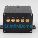
infiniDome has added a new device to its anti-jamming solutions that’s designed to defend small to medium tactical UAS: GPSdome 2, the latest generation of the company’s GPSdome.
By Inside GNSS
Autonomous technology specialists, aiMotive, and Indoor Mapping provider and connected vehicle services leader, Parkopedia, are now able to offer automakers scalable, autonomous parking solutions which minimise everyday parking hassles for drivers, without relying on the presence of additional infrastructure within parking facilities, thanks to a recent partnership.
By Inside GNSS
This fall, vendors from the Defense Innovation Unit’s (DIU) Harmonious Rook prototype project will participate in DoD and international exercises. The goal is to test commercial technology developed to detect GNSS disruption.
By Inside GNSS
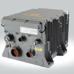
BAE Systems recently delivered its Miniature Precision Lightweight GPS Receiver Engine – M-Code (MPE-M) to Germany, with the technology providing ground-based soldiers and vehicles with precise geolocation and positioning capabilities in complex and contested operational environments.
By Inside GNSS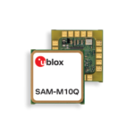
u-blox recently released the SAM-M10Q Antenna module to allow product developers to easily integrate u-blox M10 GNSS technology into their devices. Typical applications leveraging the technology include industrial tracking and telematics, automation and monitoring, and small drones.
By Inside GNSS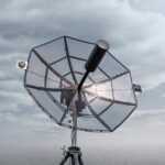
Persistent Systems recently introduced the Multi-Band Tracking Antenna with the goal of improving ground-based communication and tracking of friendly manned and unmanned aircraft, even in GPS-denied environments, helping warfighters defend against the threat of electronic warfare (EW) from near-peer adversaries.
By Renee KnightMayflower Communications has received TSO-C190 Authorization from the FAA for its Multi-Platform Anti-Jam GPS Navigation Antenna (MAGNA) systems, making them the first anti-jam (AJ) solutions authorized for installation in both civilian and military aircraft, according to the company.
By Renee Knight
Semtech’s LoRa Edge device-to-cloud geolocation platform now features multi-band capabilities, with LoRa Edge LR1120 allowing for direct satellite-connected Internet of Things (IoT) applications for supply chain management and logistics.
By Inside GNSS
Intelligent Material Solutions (IMS) is taking a new approach to helping the blind and visually impaired (BVI) navigate in cities and other environments, using a technology that dovetails on GPS to provide more precise geo-location.
By Renee Knight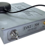
Two recent government reports have labelled Satelles’ Satellite Time and Location (STL) as a reliable source of resilient timing for critical infrastructure.
By Inside GNSS
U.S. military efforts to field jam-resistant GPS weaponry not only run behind schedule, they continue to fall back, according to the annual report from the Department of Defense (DoD) Director, Operational Test and Evaluation (DOT&E) Nickolas Guertin. Because “the lack of M-code capable receivers limits the M-code use by U.S. and allied warfighters,” branches of the Armed Forces are now sourcing directly from commercial suppliers.
By Inside GNSS
The U.S. Air Force Guided Weapons Evaluation Facility ordered a BroadSim Wavefront advanced GNSS simulator from Orolia Defense & Security for weapons testing under electronic warfare — jamming — environments, among a wide range of other conditions.
By Inside GNSS
Applanix announced its Trimble AP+ Land GNSS-inertial OEM solution for accurate and robust position and orientation for georeferencing sensors and positioning vehicles in land mobile mapping applications. It enables users to accurately and efficiently track and monitor fleets, produce high-definition (HD) maps and 3D models, or act as a reference solution for advanced driver-assistance systems (ADAS) testing, even in challenging GNSS environments.
By Inside GNSS