All applications of satellite navigation show a strong growth. They can now rely on four global systems (GPS, GLONASS, Galileo and BeiDou) and additional regional systems, sometimes aiming for future global extension (QZSS, NavIC). All these systems and their applications rely on very limited satellite orbit spectrum. This article is providing background and insights on the growing pressure on this limited resource, giving rise to proposals for “sharing” spectrum. How satellite navigation will survive and find the necessary spectrum resources to grow is reviewed in details in the following paragraphs.
ITU is the United Nations specialized agency for information and communication technologies – ICTs. As such the ITU allocates global radio spectrum and satellite orbits, develops the technical standards that ensure networks and technologies seamlessly interconnect, and strives to improve access to ICTs to underserved communities worldwide. ITU is committed to connecting the entire world’s people – wherever they live and whatever their means. Through its work, ITU protects and supports everyone’s fundamental right to communicate.
The ITU Constitution (CS), Convention (CV) and the Radio Regulations (RR) contain the main principles and lay down the specific regulations governing the following major elements:
- frequency spectrum allocations to different categories of radiocommunication services;
- rights and obligations of Member administrations in obtaining access to the spectrum/orbit resources;
- international recognition of these rights by recording frequency assignments and, as appropriate, orbital information for a space station onboard a geostationary-satellite or for space station(s) onboard non-geostationary satellite(s), in the Master International Frequency Register (MIFR) or by their conformity, where appropriate, with a plan.
The ITU grants international recognition, a level of protection conditioned by the provisions of the RR and by procedures to detect and to eliminate Harmful Interference (HI) for registered assignments in the MIFR. The ITU also promotes the rational, efficient, economic, and equitable use of the radio frequency and orbital positions, which are limited natural resources and, as such, must be available for use by all Member States. In this regard, the ITU gives special consideration to the future use of these resources by developing countries.
The fact that the ITU CS and CV and the RR that complement them are intergovernmental treaties ratified by governments means that those governments undertake:
- to apply the provisions in their countries; and
- to adopt adequate national legislation that includes, as the basic minimum, the essential provisions of this international treaty.
![]()
RNSS Users
RNSS receivers are used today for a wide range of applications, including safety-of-life, critical navigation on land, at sea, and in the air (see Table 1, at the end of this article). According to GNSS Market Report 2017, available here, RNSS is used around the globe, with an estimated 5.8 billion RNSS devices in use in 2017. This number is expected to grow to 8 billion by 2020.
RNSS and definitions from the ITU RR
The following main definitions from the ITU RR apply to the RNSS:
- No. 1.43 radionavigation-satellite service (RNSS): A radiodetermination-satellite service used for the purpose of radionavigation
- No. 1.59 safety service: Any radiocommunication service used for the safeguarding of human life and property
- No. 4.10 Member States recognize that the safety aspects of radionavigation and other safety services require special measures to ensure their freedom from harmful interference; it is necessary therefore to take this factor into account in the assignment and use of frequencies.
- No 1.166 interference: The effect of unwanted energy due to one or a combination of emissions, radiations, or inductions upon reception in a radiocommunication system, manifested by any performance degradation, misinterpretation, or loss of information which could be extracted in the absence of such unwanted energy.
- No 1.167 permissible interference: Observed or predicted interference which complies with quantitative interference and sharing criteria contained in these Regulations or in ITU-R Recommendations or in special agreements as provided for in these Regulations.
- No 1.168 accepted interference: Interference at a higher level than that defined as permissible interference and which has been agreed upon between two or more administrations without prejudice to other administrations.
- No 1.169 harmful interference (HI): Interference which endangers the functioning of a radionavigation service or of other safety services or seriously degrades, obstructs, or repeatedly interrupts a radiocommunication service operating in accordance with Radio Regulations.
The ITU RR is recognizing a special status of radionavigation services and instructing the Member administrations to take all practicable and necessary steps to ensure that the operation of electrical apparatus or installations of any kind, including power and telecommunication distribution networks, does not cause harmful interference to a radiocommunication service and, in particular, to a radionavigation or any other safety service operating in accordance with the provisions of the RR.
The Radionavigation Satellite Service History
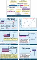
The Radionavigation Satellite Service (RNSS) is part of the global critical infrastructure and probably the most dynamic satellite service today, creating a big professional as well as public interest. It started in the 1980s with two military satellite systems: NAVSTAR GPS (USA) notified to the Bureau on 08.10.1979 and GLONASS (RUS) notified on 04.11.1982, in the bands 1559 to 1610 MHz (L1 band/signals) and 1215 to 1260 MHz (L2 band/ signals). Due to the military nature of the systems and because of the L1 band sharing with PRIMARY fixed terrestrial service within 44 administrations, global utilization of the RNSS for civil applications and by general public was very limited in the 1990s. For more info see here.
WRC-2000 — New RNSS Allocation and Extension of Old RNSS Allocation
In addition to the original RNSS systems operating in the 1559 to 1610 MHz and 1215 to 1260 MHz bands, several new systems were planned in the late 1990s. Based on studies, it was clear that the existing RNSS allocations were already extensively used, and would continue to undergo an extremely rapid expansion. As a result, all existing worldwide RNSS allocations should be retained for RNSS use. There was also a requirement for additional RNSS spectrum in the bands between 1 and 6 gigahertz to support worldwide satellite navigation developments in both the space-to-Earth and Earth-to-space directions of transmission. These additional RNSS allocations will enable GNSS operations with greatly improved performance characteristics (accuracy, availability and continuity). GNSS operations in widely spaced multiple frequency bands is necessary to support improved ionosphere corrections and phase tracking capabilities, which are essential for robust and precise navigation. An RNSS system using higher code rates to give better navigation accuracy and reduce multipath errors is required to satisfy the navigation requirements used in the future.
Based on the above requirements, the ITU World Radiocommunication Conference (WRC) WRC-2000 in Istanbul, Turkey introduced new RNSS allocations and significant changes to the RNSS regulatory status. The WRC instructed the ITU-R to conduct urgent studies on RNSS sharing criteria with other services:
- Resolution 605 (WRC-2000) introduced a new RNSS band 1164-1215 MHz (L5 band/ signals) open for all new RNSS systems, but in the same time protecting the existing primary Aeronautical Navigation Service (ARNS) already allocated in this band;
- Resolution 606 (WRC-2000) extended the RNSS band for L2 band/signals up to 1300 MHz, but no additional constraints shall be placed on the RNSS systems and other services already operating in the band 1215 to 1260 MHz. In the same time, Resolution 607 (WRC-2000) instructed the ITU-R Study groups for urgent studies on compatibility between stations of the RNSS and the Radiolocation service (RL) operating in the frequency band 1240 to 1300 MHz;
- Resolution 603 (WRC-2000) introduced a new RNSS band 5000 to 5010 MHz (Earth-to-space). This resolution instructed the ITU-R Study groups for interference studies on compatibility between stations of the RNSS and the international standard system microwave landing system (MLS) operating in the band 5 030-5 150 MHz;
- Resolution 604 (WRC-2000) introduced a new RNSS band 5010 to 5030 MHz (C1 band/signals). This resolution instructed the ITU-R Study groups for urgent interference studies on compatibility between stations of the RNSS and the RAS in the frequency band 4990 to 5000 MHz;
- WRC-2000 also modified the footnote No. 5.362C to allocate the band 1559 to 1610 MHz band to the fixed service (FX) on a primary basis until 01.01.2005 [list of ADM] and until 01.01.2010 [list of ADM]. After these dates, the fixed service may continue to operate on a secondary basis until 01.01.2015, at which time this allocation shall no longer be valid. Administrations are urged to take all practicable steps to protect the RNSS and the ARNS and not authorize new frequency assignments to FX service systems in this band.
The WRC-2000 decisions had been very significant in relation to RNSS. Several new Advance Publication Information (API) for RNSS systems were submitted to the Bureau after WRC-2000: COMPAS (CHN), MSATNAV and LSATNAV (F/GLS), GLONASSM (RUS), NAVSTAR GPS L5 (USA), N-SAT-HEO (JPN) and INSAT-NAV (IND).
Current RNSS Regulation – ITU RR @2016
ITU-R study groups finished during the 2000-2003 period all studies as requested by the above-mentioned resolutions adopted by WRC-2000 with the following recommendations:
- For the band 1164 to 1215 MHz an aggregate protection criterion for ARNS incorporated into the RR was proposed with compliance to be assured by administrations. This method mandates the provision of aggregate interference protection to the ARNS at the level identified in ITU-R studies, regardless of the number of RNSS systems operating in the band. It commits enforcement of the requirement to those administrations that operate or intend to operate RNSS systems. This method would manage the total amount of interference caused by these systems through the collaborative agreement on the part of administrations proposing and operating the RNSS systems, and there would be no additional regulatory task for the Bureau to validate compliance with the protection criterion. There would be a need for coordination between RNSS administrations having GSO/non-GSO networks under Article 9 RR, and associated transitional measures, that would entail discussion between RNSS operators. This process would commence at an early point in the implementation of the system. There would also be a need for consultation among RNSS administrations under the provisions of the proposed new resolution and associated provisions in the RR to ensure that the aggregate protection criterion is met. Since RNSS operators should know sufficiently in advance the conditions under which their systems would operate, the consultations should be open to any administration having sent complete coordination or notification information to the Bureau. However, only “real” systems should be included in the calculations. A mechanism needs to be put into place to determine which systems are “real” for purposes of participating in the calculations.
- For the band 1215 to 1300 MHz, based on 12 years of operational experience by the GPS system in the frequency range 1215 to 1240 MHz and over 10 years of operational experience by the GLONASS system in the frequency range 1240 to 1260 MHz, RNSS signals have successfully demonstrated co-primary sharing between this RNSS system and radars in the band 1215 to 1260 MHz. Operational experience with current GPS and GLONASS system characteristics in the 1215 to 1260 MHz band has not led to any reports of harmful interference being caused to existing radar systems.
- For the band 5010 to 5030 MHz, due to the fact that unwanted emissions from space stations of the RNSS in the frequency band 5010 to 5030 MHz may cause interference to the radio astronomy service (RAS) operating in the nearby band 4990 to 5000 MHz, RNSS systems operating in such band shall comply with the pfd and aggregated epfd limits. In order not to cause harmful interference to the microwave landing system (MLS) operating above 5030 MHz, an aggregate pfd by all RNSS systems (space-to-Earth) shall apply.
Subsequently, the WRC-03 in Geneva, Switzerland finalized the new RNSS regulations in the bands 1164 to 1215 MHz, 1240 to 1300 MHz and 5010 to 5030 MHz, with the following results:
- RESOLUTION 608 (WRC-03) Use of the frequency band 1215 to 1300 MHz by systems of the radionavigation-satellite service (space-to-Earth)
- RESOLUTION 609 (WRC-03) Protection of aeronautical radionavigation service systems from the equivalent power fluxdensity produced by radionavigation satellite service networks and systems in the 1164 to 1215 MHz frequency band
- RESOLUTION 610 (WRC-03) Coordination and bilateral resolution of technical compatibility issues for radionavigation-satellite service networks and systems in the bands 1164 to 1300 MHz, 1559 to 1610 MHz and 5010 to 5030 MHz
- RESOLUTION 741 (WRC-03) Protection of the radio astronomy service in the band 4990 to 5000 MHz from unwanted emissions of the radionavigation-satellite service (space-to-Earth) operating in the frequency band 5010 to 5030 MHz
- RECOMMENDATION 608 (WRC-03) – Guidelines for consultation meetings established in Resolution 609 (WRC-03)
Results of WRC-03 decision guarantees long term sustainable development of new RNSS systems, protecting of existing RNSS systems and sharing criteria with other radiocommunication services operating in the same or adjacent bands. Several new RNSS systems and regional augmentation systems were recorded in the MIFR and declared bringing into use – MSATNAV (F/GLS) – 03.03.2006, COMPAS (CHN) – 26.03.2007, GLONASS-M (RUS) – 17.01.2009, NAVSTAR GPS-IIRF (USA) – 10.04.2009, N-SAT-HEO-2 (JPN) – 28.12.2007 and INSAT-NAV (IND) – 30.04.2012.
For the complete list see here.
WRC-12 Extension for the Radiodetermination-Satellite Service (RDSS)
The band 2483.5 to 2500 MHz is intended to facilitate navigation signals for existing RDSS systems in this band to be used globally and to support potential signals from new RDSS systems, which, because of this band’s proximity to mobile service allocations above 2.5 gigahertz, may offer attractive synergies with terrestrial mobile systems due to improved antenna efficiencies and use of shared hardware not possible with other RNSS bands.
Readers may find complete information about all RNSS allocations, including associated footnotes and Resolutions, in the ITU RR @ 2016 here.
The sharing of the band 1164 to 1215 MHz between ARNS and RNSS is managed in application of Resolution 609. For more info see – RES-609 Consultation Meeting.
The basic concepts of RES-609 are:
(a) All potential RNSS system operators and ADMs are given full visibility of the process
(b) No single RNSS system shall be permitted to use up the entire interference allowance
(c) ADMs operating or planning to operate RNSS systems will need to agree cooperatively to achieve the level of protection for ARNS
(d) ADMs participating in this process of epfd calculation should hold Consultation meetings on a regular basis
(e) Up to now, 14 RES-609 meetings were held, for more information see the RES-609 link above.
(f) Conclusion of the last 14th RES-609 Consultation meeting – The maximum aggregate epfd of satellites associated with the referenced RNSS networks and systems is determined to be no greater than –121.98 dB(W/(m2∙MHz)), i.e. 0.48 decibels below the Resolution 609 limit of –121.5 dB(W/(m2∙MHz)). It is noted that the result is based on the use of worst-case assumptions in terms of interference from RNSS into ARNS.
1215 – 1300 MHz band regulation
Use of the RNSS service in the band 1215 to 1300 MHz shall be subject to the condition that no harmful interference is caused to, and no protection is claimed from, the radionavigation service (RNS) authorized under No. 5.331 RR. Furthermore, the use of the radionavigation-satellite service in the band 1215 to 1300 MHz shall be subject to the condition that no harmful interference is caused to the radiolocation service. No. 5.43 RR shall not apply in respect of the radiolocation service (RLS). Resolution 608 (WRC-03) – no constraints in addition to the RNSS systems in the frequency band 1215 to 1260 MHz brought into use until June 2, 2000.
1559 – 1610 MHz band regulation
Co-Primary RNSS and ARNSS band: The use of this band is subject to the application of the provisions of Nos. 9.12, 9.12A and 9.13 RR. Resolution 610 shall also apply.
2483.5 – 2500 MHz band regulation
This is a co-primary allocation of FIXED (FX), MOBILE (MOB), MOBILE-SATELLITE (MS) and RADIODETERMINATION SATELLITE (RDSS) services. The use of the band 2483.5 to 2500 MHz by the MS and RDSS is subject to the coordination under No. 9.11A RR. Administrations are urged to take all practicable steps to prevent harmful interference to the RAS, especially those caused by second-harmonic radiation that would fall into the 4990 to 5000 MHz band allocated to the RAS worldwide. This band is also designated for industrial, scientific and medical (ISM) applications. Radiocommunication services operating within these bands must accept harmful interference which may be caused by these applications. ISM equipment operating in these bands is subject to the provisions of No. 15.13 RR.
5000 – 5030 MHz band regulation
The band 5000 to 5010 MHz is used by the Galileo RNSS system for the operation of feeder-link stations transmitting navigation mission information to the satellites. Through feeder links, all system and navigation mission relevant information is transferred to the Galileo satellites comprising ephemerides, clock correction information, service integrity messages and all other data elements of the navigation message that require continuous updates. The feeder link is not intended for user access. Up to 20 uplink earth stations, using the RNSS (Earth-to-space) allocation in the 5000 to 5010 MHz frequency band are operated from geographical locations worldwide to enable access to each satellite in the constellation at any time.
In order not to cause harmful interference to the microwave landing system (MLS) operating above 5030 MHz, the aggregate pfd produced at the Earth’s surface in the frequency band 5030 to 5150 MHz by all the space stations within any RNSS systems operating in the frequency band 5010 to 5030 MHz shall not exceed −124.5 dB(W/m2) in a 150 kilohertz band. In order not to cause harmful interference to the RAS service in the frequency band 4990 to 5000 MHz, RNSS systems operating in the frequency band 5010 to 5030 MHz shall comply with the limits in the frequency band 4990 to 5000 MHz defined in Resolution 741.
List of ITU-R Recommendations Related to RNSS
The following represents a selection of the most important ITU-R recommendations related to RNSS.
- ITU-R M.1582 – Method for determining coordination distances, in the 5 GHz band, between the international standard microwave landing system stations operating in the aeronautical radionavigation service and stations of the radionavigation-satellite service
- ITU-R M.1583 – Interference calculations between non-geostationary mobile-satellite service or radionavigation-satellite service systems and radio astronomy telescope sites
- ITU-R M.1584 – Methodology for computation of separation distances between earth stations of the radionavigation-satellite service (Earth-to-space) and radars of the radiolocation service and the aeronautical radionavigation service in the frequency band 1300 to 1350 MHz
- ITU-R M.1787 – Description of systems and networks in the radionavigation-satellite service and technical characteristics of transmitting space stations operating in the bands 1164 to 1215 MHz, 1215 to 1300 MHz and 1559 to 1610 MHz
- ITU-R M.1831 – A coordination methodology for RNSS inter-system interference estimation
- ITU-R M.1901 – Guidance on ITU-R Recommendations related to systems and networks in the radionavigation-satellite service operating in the frequency bands 1164 to 1215 MHz, 1215 to 1300 MHz, 1559 to 1610 MHz, 5000 to 5010 MHz and 5010 to 5030 MHz
- ITU-R M.1902 – Characteristics and protection criteria for receiving earth stations in the radionavigation-satellite service (space-to-Earth) operating in the band 1215 to 1300 MHz
- ITU-R M.1903 – Characteristics and protection criteria for receiving earth stations in the radionavigation-satellite service (space-to-Earth) and receivers in the aeronautical radionavigation service operating in the band 1559 to 1610 MHz
- ITU-R M.1904 – Characteristics, performance requirements and protection criteria for receiving stations of the radionavigation-satellite service (space-to-space) operating in the frequency bands 1164 to 1215 MHz, 1215 to 1300 MHz and 1559 to 1610 MHz
- ITU-R M.1905 – Characteristics and protection criteria for receiving earth stations in the radionavigation-satellite service (space-to-Earth) operating in the band 1164 to 1215 MHz
- ITU-R M.1906 – Characteristics and protection criteria of receiving space stations and characteristics of transmitting earth stations in the radionavigation-satellite service (Earth-to-space) operating in the band 5000-5010 MHz
- ITU-R M.2030 – Evaluation method for pulsed interference from relevant radio sources other than in the radionavigation-satellite service to the radionavigation-satellite service systems and networks operating in the 1164 to 1215 MHz, 1215 to 1300 MHz and 1559 to 1610 MHz frequency bands
- ITU-R M.2031 – Characteristics and protection criteria of receiving earth stations and characteristics of transmitting space stations in the radionavigation-satellite service (space-to-Earth) operating in the band 5010-5030 MHz
- ITU-R M.2082 – Methodology and technical example to assist coordination of the mobile-satellite service and the radiodetermination-satellite service with the fixed service based on the power flux-density coordination trigger levels in the 2483.5 to 2500 MHz band
For the purpose of providing protection criteria for RNSS systems, RNSS receiver types for particular applications were described in the above referenced M-Series Recommendations. Recommendation ITU-R M.1787 provides descriptions of systems and networks in the RNSS and technical characteristics of transmitting space stations operating in the bands 1164 to 1215 MHz, 1215 to 1300 MHz and 1559 to 1610 MHz. Recommendations ITU-R M.1905, ITU-R M.1902, ITU-R M.1903 and ITU-R M.1904 provide technical and operational characteristics of, and protection criteria for, receiving stations in the RNSS systems operating in the RNSS bands.
Conclusion
Since WRC-2000, the regulatory framework related to RNSS has been constantly adapted to changing circumstances with the dramatic development in satellite-based global navigation services. Introduction of new frequency bands and modifications of the ITU RR and related procedures guarantee a sustainable development of this critical global infrastructure.
The recent review of the ITU MIFR shows that all global RNSS systems are successfully registered and brought into use following the procedure for notification and recording of space network frequency assignments in the MIFR as described in Article 11 of the Radio Regulations. The MIFR represents one of the pillars of the international radio regulatory regime as it contains all frequency usage notified to ITU. It should be consulted before selecting a frequency for any new user. For these reasons, notification of frequency assignments to the Bureau, with a view to their recording in the MIFR, represents an important obligation for administrations, especially in respect to those frequency assignments that have international implications.
The benefits and importance of RNSS should be recognized as a service used in many applications, including critical infrastructure, and in this respect all efforts should be undertaken to minimize interference (including jamming and spoofing) into RNSS that may affect physical and cyber security of personal life and society and to keep such occurrences and their impact to a controlled minimum. This can be achieved through a series of actions relating inter-alia to the following:
- Compliance with the ITU Constitution and Radio Regulations;
- Exchange of information and cooperation between administrations, satellite operators, service and content providers, industry, organizations and associations involved in satellite communications;
- Utilization of ITU Recommendations, standards, procedures;
- Participation in trainings;
- Utilization of new technologies, including use of the international monitoring system;
ITU has been playing the role listed above, and will continue to do so, by providing the required assistance to its members in order to ensure and maintain the interference-free operation of space services, a challenging strategic goal under the Radiocommunication Bureau’s core responsibilities.
ITU holds the firm conviction that only the continuous synergistic implementation of the above actions by all sectors involved in satellite radiocommunication can guarantee that harmful interference is kept to a minimum for the satellite community and end users.
Additional Resources
[1] CPM Reports and Final Acts WRC
[2] ITU Radio Regulations, Edition of 2016
[3] ITU-R Recommendations – M. series
[4] ITU-R Space Services Department (SSD)
[5] RES-609 Consultation meeting
[6] Space Network List (SNL) online
[7] Working Party 4C – Efficient orbit/spectrum utilization for the mobile-satellite service and the radiodetermination-satellite service
TABLE 1: Examples of RNSS users
AGRICULTURE and FORESTRY
- Forest area and timber estimates.
- Identifying species habitats.
- Fire perimeters.
- Water resources.
- Locating property boundaries.
- Ploughing, planting and fertilizing without operators.
AVIATION
- Oceanic and en route navigation.
- Non-precision and precision all-weather approaches.
- Direct routing of aircraft for fuel savings.
- Improved aircraft separation standards for more efficient air traffic management.
- Airport surface traffic management.
- Monitor wing deflections in flight.
- Wind shear detection.
- Precise airfield and landing aid locations.
- Seamless (global) air space management.
- Less expensive avionics equipment.
- Monitoring aircraft locations in flight.
- Precision departures.
- Missed approach applications.
- Enhanced ground proximity warning system.
- Automatic dependent surveillance.
ELECTRIC POWER
- Synchronization of power levels.
- Event location.
EMERGENCY RESPONSE
- Ambulance, police, and fire department dispatch.
- Road service locating disabled vehicles.
ENVIRONMENTAL PROTECTION
- Hazardous waste site investigation.
- Ground mapping of ecosystems.
- Oil spill tracking and cleanup.
- Precise location of stored hazardous materials.
HIGHWAY and CONSTRUCTION
- Intelligent vehicle-highway system operation.
- Highway facility inventory and maintenance.
- Accident location studies.
- Highway construction.
- Navigation for motor vehicle drivers.
- Truck fleet on-the-road management.
- Monitoring status of bridges.
LAW ENFORCEMENT and LEGAL SERVICES
- Tracking and recovering stolen vehicles.
- Tracking narcotics and contraband movements.
- Maintaining security of high government officials and dignitaries while travelling.
- Border surveillance.
- Measuring and recording property boundaries.
- Tort claim evidence in aviation and maritime accidents.
MARITIME and WATERWAYS
- Navigation on the high seas.
- Search and rescue.
- All weather harbour approach navigation.
- Vessel traffic services.
- Dredging of harbours and waterways.
- Positioning of buoys and marine navigation aids.
- Navigation for recreational vessels.
- Location of commercial fishing traps and gear.
- Offshore drilling research.
- Monitoring deflections in dams as a result of hydrostatic and thermal stress changes.
- Ice breaking and monitoring icebergs and flows.
- Observing tides and currents.
- Harbour facility management.
- Location of containers in marine terminals.
PUBLIC TRANSPORTATION
- Bus fleet on-the-road management.
- Passenger and operator security monitoring.
RAILROAD
- Railroad fleet monitoring.
- Train control and collision avoidance.
- Facility inventory control and management.
RECREATION
- Hiking and mountain climbing.
- Measuring at sports events.
- Setting lines on sports fields.
SURVEYING
- Electronic bench marker providing
- absolute reference of latitude, longitude and altitude.
- High precision surveys in minutes by anyone.
- Real-time dam deformation monitoring.
- Hydrographic surveying.
- Efficient and accurate photo surveys.
- Measuring areas without triangulation.
- Oil and mineral prospecting.
- National spatial data infrastructure.
TELECOMMUNICATIONS
- Precise timing for interlacing messages/network synchronization.
WEATHER, SCIENTIFIC and SPACE
- Use as weather balloon position radiosonde.
- Measurement of sea level from satellites.
- Navigating and controlling space shuttles.
- Placing satellites into orbit.
- Monitoring earthquakes and tectonic plates.
- Measuring ground subsidence (sinking).
- Measuring atmospheric humidity from ground.
- Precise global mapping of ionosphere.


