The recent release of the 2010 Federal Radionavigation Plan (FRP) marks the passage of a recurring milestone for the U.S. positioning, navigation, and timing (PNT) community.
The recent release of the 2010 Federal Radionavigation Plan (FRP) marks the passage of a recurring milestone for the U.S. positioning, navigation, and timing (PNT) community.
Since the first edition of appeared in 1980 as part of a presidential report to Congress, the FRP — part history, part vision, part plan — has become a fixture of the U.S. policy landscape. A useful guide for the various PNT user communities, the FRP also charts the rise and fall of various navigation technologies and program. Copies of the plan can be downloaded from the U.S. Coast Guard Navigation Center.
Originally intended to address coordinated planning by the Department of Defense (DoD) and the Department of Transportation (DoT) for federally provided radionavigation systems, the planning process has evolved to include other elements of navigation and timing. With the advent of the Global Positioning System in the 1990s and other GNSSes later, space-based PNT began to inform — even dominate — the FRP discussion. The last couple of plans, however, have reflected a growing awareness of the limitations and vulnerability of GNSS, and begun to emphasize the need for backups and alternatives to space-based PNT.
The 2010 FRP was released officially under the signatures of the secretaries of defense, transportation, and homeland security, with DoT Secretary Ray LaHood signing off first last December and DoD Secretary Robert Gates being the last to sign on April 15.
Key players behind the scenes for producing the 2010 FRP included the U.S. Department of Transportation’s Research and Innovative Technology Administration (RITA) and staff at the Joint Planning and Development Office (JPDO), who did the heavy lifting on coordination of the 2010 FRP. Congress established the multi-agency JPDO in 2003 to plan and coordinate the development of the Next Generation Air Transportation System (NextGen).
The DoT Extended Pos/Nav, DoD PNT, and Department of Homeland Security (DHS) PNT Working Groups also met regularly to facilitate the coordination process.
The More Things Don’t Change. . . .
A classic example of a “living document,” much of the content of FRP carries over from one version to the next, filled with the nuances and tweaking of language typical of such ongoing endeavors. “Radionavigation systems,” for example, have become “PNT systems,” and the section on GPS Back has become GPS Backup for Critical Infrastructure.
In discussing the FAA’s Local Area Augmentation System (LAAS), the new FRP notes, “To coincide with international terminology, the FAA is also adopting the term GBAS [ground-based augmentation system] to be consistent with the international community.” Language has changed from future tense to present tense and a cool new graphic added, probably reflecting progress in developing the system and a stabilizing of support for the program.
Numerous sections have also been rearranged, usually to create a more logical order but sometimes the purpose isn’t clearly apparent.
For example, six subsections on mitigating disruptions in various modalities — Aviation, Maritime, Land and Railroad Operations, and Non-Navigation NASA Applications — moved from the Policy section to the Operating Plans section.
The move is somewhat puzzling, because most of the language is identical and doesn’t contain a planning component except for one added bullet point: “FAA is currently developing requirements and recommendations for future alternative PNT solutions that address mitigations for GPS disruptions.”
Readers may need to look carefully to detect apparently minor changes that may (or may not) signify important details. For instance, the GPS Modernization section removed this sentence: “The first GPS III launch is projected for 2014.” And the GPS Signal Monitoring section now underlines that the U.S. government “does not currently monitor and assess SPS performance in real-time.”
On the other hand, repetition of language from one version to the next can reflect that not much is going on at all with a program or initiative.
For instance, two years after the 2008 FRP, the identical language appears in the section on Backup for Critical Infrastructure regarding the DHS responsibility for “determining whether alternative backups or contingency plans exist across the critical infrastructure and key resource sectors identified in the National Infrastructure Protection Plan in the event of a loss of GPS-based services.”
The same goes for the section on Interference Detection and Mitigation (IDM), again, primarily a DHS responsibility.
Vulnerability of GPS for Critical Infrastructure adds a section noting that the new National Space Policy released by the Obama administration in June 2010 states that “the U.S. shall invest in domestic capabilities and support international activities to detect, mitigate, and increase resiliency to harmful interference to GPS, and identify and implement, as necessary and appropriate, redundant and backup systems or approaches for critical infrastructure, key resources, and mission-essential functions.”
The policy and plans for mitigation of disruptions to satellite-based PNT services refers to sections of the 2010 FRP where the DHS leadership role is described.
“DHS developed and published the National Positioning, Navigation, and Timing, Interference Detection and 1-9 Mitigation (IDM) Plan (August 2007) and the National IDM Plan Implementation Strategy (January 2008) to address these concerns. These documents provide a framework and guidance from which to execute the responsibilities required to fulfill the directives from the U.S. Space-Based PNT Policy.”
Indeed, the DHS effort on alternatives, backups, and IDM appears stalled.
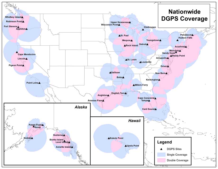
Likewise, building out of the Nationwide Differential GPS System (NDGPS) does not appear to have advanced since 2008, when the system was nearing full continental United States (CONUS) coverage (then 92 percent). The system is still at the 92 percent level, and 2008 milestones for full single-station and two-station CONUS coverage, 2010 and 2012, have been extended by two years each, with the caveat “pending funding availability.”
The system’s design is based on the USCG’s DGPS maritime service that began initial operation in 1996 and transmits real-time differential corrections from the reference stations on a medium frequency maritime radiobeacon band of 285-325kHz.
The 2010 document does, however, confirm completion in 2009 of an NDGPS recapitalization project for the maritime sites introduced in the previous version. This project will extend system life at least 15 years and provided a substantial increase in performance (accuracy and integrity), flexibility, and maintainability.
Waxing and Waning Fortunes
Coverage of particular subjects expands and shrinks over the years. Sections on Loran-C, of course, have been scrubbed from the policy and operations sections in the 2010 version, and a new section added on Loran’s termination last year, following a decision by President Obama. The consequences of this decision appears clearly in the section on GPS Backups, where the reversal of fortunes of enhanced Loran (eLoran) is reflected in changes between the 2008 and 2010 versions.
The DoD Operational Management section elaborates on the role of the Joint Chiefs of Staff, adding details on Joint Staff (J-3) and Joint Staff (J-8) responsibilities, in addition to those of Joint Staff (J-6) described in the 2008 plan:
Joint Staff (J-3) oversees CJCSM 3212.03 (Ref. 24), which implements guidance to request and gain approval to conduct electronic attack (EA) tests, training and exercises (TT&Es) that affect GPS with the U.S., Mexico, and Canada. Joint Staff (J-3) reviews all EA TT&E packages, coordinates first with the Joint Spectrum Center for quality assurance, and then coordinates the final package with DoD and Interagency stakeholders (e.g., FAA, USCG, etc.).
The Directorate for Command, Control, Communications, and Computer Systems Support, Joint Staff (J-6), is responsible for analysis, evaluation, and monitoring of PNT system planning and operations; general joint warfighter PNT matters; authoring and publishing the Joint Chiefs of Staff Instruction 6130.01D on the DoD Master Positioning, Navigation, and Timing Plan, and chairs the Netcentric Functional Capabilities Board (NC FCB) (first level of the Joint Capabilities Integration and Development System (JCIDS) review for DoD and Interagency PNT requirements).
Joint Staff (J-8) acts as the gatekeeper for JCB and Joint Requirements Oversight Council (JROC) review of DoD and Interagency PNT requirements that are approved by the NC FCB. Joint Staff (J-8) also (in coordination with various DoD and interagency partners) establishes guidance for the Interagency Requirements Process (IRP).
As the opening of Section 4, PNT User Requirements, underlines, “The FRP is not intended to be a requirements document.” Instead, it is designed “to provide context” for the PNT systems provided by the U.S. government.
However, by bringing the requirements of the various modalities together in the same place, updating them as needed, and referencing the original requirements-document sources, the FRP provides a convenient codification for the various transportation user communities.
In particular, the sections on aviation and maritime requirements — both with safety-of-life ramifications — provide extensive details on what users can expect from GPS and other navigation systems. Here the discussion goes beyond requirements to describe the environments and procedures for phases of operation.
Land transportation has gotten more attention, with tables laying out highway and trucking user services with associated measures of PNT performance criteria familiar to other modes of transportation, such as accuracy, availability, integrity, and time to alert.
Similarly, Space PNT requirements received more extensive treatment than in the previous version of the plan, with a table outlining various categories of metrics — with specifications not yet determined — for on-board autonomous navigation and a variety of scientific missions.
An addition to the user requirements section in the 2010 version is for sub-surface PNT in both marine and land applications. As the new FRP observes, “The subsurface environment makes practical employment of traditional PNT sensors and systems, such as GPS, more of a challenge.”
Although the minimum performance criteria charts are filled with TBD notations, indicating that these are still to be determined, the new category marks an interesting expansion of the FRP’s scope.
On the other hand, treatment of timing requirements appears to have become less complete than the 2008 plan, with a reconfigured table of performance criteria providing only specifications for accuracy in relation to UTC time. However, a section has been added on the U.S. Naval Observatory (USNO) and National Institute of Standards and Technology (NIST) timing plans for time dissemination, including GPS, Two-Way Satellite Time Transfer (TWSTT), Network Time Protocol (NTP), and telephone voice announcers.
The FRP discussion ends with a description of the National PNT Architecture, an ambitious project to advanced by DoD and DoT to sketch an overarching view of an “as-needed” system of systems circa 2025.
A National PNT Enterprise Architecture Study recommendations were accepted by DoD and DOT leadership in June 2008. But the 2010 section seems to add a caveat to realizing this vision.
“The product of transition planning, the National PNT Architecture Implementation Plan, can be viewed as an evolving structure that encompasses many separate but interrelated plans, system capabilities, standards, and policies,” the new FRP states. “A step in this evolution will be to help the PNT community understand the relationship of Federal PNT systems plans and policies beyond those covered by radionavigation systems through a continued effort to document the National PNT enterprise in a series of architectural framework products.
“Developing these products and implementing the plan requires a strong and continued commitment of the PNT community stakeholders who have developed the plan. The processes that coordinate stakeholder activities will likely need to evolve as the implementation of the PNT architecture progresses and the PNT architecture itself continues to evolve.”
In this effort, the FRPs will continue to play a significant role.


