NOAA’s National Geodetic Survey (NGS) recently announced an approved set of NGS user guidelines for increasingly popular single base real-time (RT) GNSS positioning that provide definitive criteria to achieve various specific levels of precision down to centimeter accuracy at a 95 percent confidence level.
NOAA’s National Geodetic Survey (NGS) recently announced an approved set of NGS user guidelines for increasingly popular single base real-time (RT) GNSS positioning that provide definitive criteria to achieve various specific levels of precision down to centimeter accuracy at a 95 percent confidence level.
NGS officials said the agency undertook the project because a consistent documented approach was lacking for using this technology to best advantage due to the plethora of variables associated with RT GNSS positioning. Bill Henning, an NGS senior geodesist, served as principal author for the publication.
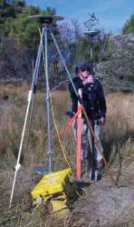
The RT technique employs GNSS technology to produce and collect three-dimensional (3-D) positions relative to a fixed (stationary) base station with expected relative accuracies in each coordinate component on the order of a centimeter, using minimal epochs of data collection.
Baseline vectors are produced from the antenna phase center (APC) of a stationary base receiver to the APC of the rover antenna using the Earth-Centered, Earth-Fixed (ECEF) X,Y,Z Cartesian coordinates of the World Geodetic System 1984 (WGS 84). The coordinates of the point of interest at the rover position are then obtained by adding the vector (as a difference in Cartesian coordinates) to the station coordinates of the base receiver, and applying the antenna height above the base station mark and also the height of the rover pole.
According to the NGS publication, GNSS positions can be expected to be more accurate when one position that is obtained at a particular time of day is averaged with a redundant position obtained at a time staggered by three to four hours (and thus with different satellite geometry), which commonly produces different results at the staggered times.
In preparing the 151-page document, thousands of pages were researched to evaluate, refine, and compile comprehensive information into an integrated form in an effort to ensure that the most practical and reliable methodologies were developed for high-precision work.
Separate chapters cover equipment, RT GNSS positioning concepts (such as atmospheric effects on signals, multipath, and dilution of precison), preparations for a survey, and field procedures. One section compares the benefits and drawbacks of single-base RT positioning and positioning using RT GNSS networks. The well-illustrated guidelines also summarize the recommended best methods for RT GNSS positioning.
An extensive glossary of GNSS positioning terminology and several appendices with papers and notes covering such topics as differencing and ambiguity resolution, low distortion map projections, and determining survey project coordinates and heights.
NGS expects that the guidelines will be updated as new developments affect RT procedures and data. The guidelines may be download in PDF format here.
For additional information, contact Bill Henning by e-mail.


