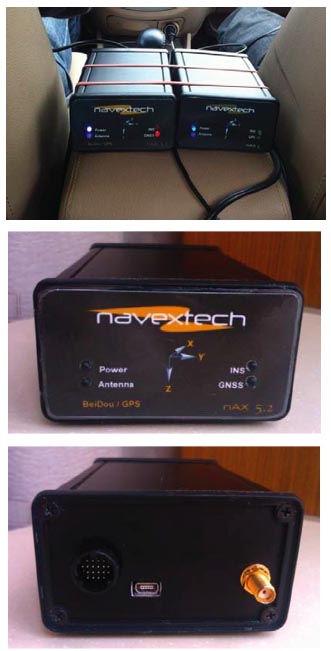
 GPS/BeiDou/MEMS configuration and GPS/MEMS configuration (left and right, respectively, top photo), Front view (center photo) and back view (lower photo) of nAX5.2
Due to the huge success of GPS in both military and civil applications, several other GNSSs have been developed, built, and operated in the last few decades. GNSS, regional, and augmentation systems are comprise a growing family that also includes GLONASS, Galileo, BeiDou, and Japan’s Quasi-Zenith Satellite System (QZSS). New members, such as the Global Indian Navigation System (GINS), are preparing to join in next decade.
Due to the huge success of GPS in both military and civil applications, several other GNSSs have been developed, built, and operated in the last few decades. GNSS, regional, and augmentation systems are comprise a growing family that also includes GLONASS, Galileo, BeiDou, and Japan’s Quasi-Zenith Satellite System (QZSS). New members, such as the Global Indian Navigation System (GINS), are preparing to join in next decade.
Multiple GNSSs not only provide users with multiple choices as to which system or systems to employ, but also improve accuracy and reliability of the GNSS receivers by using the compatible and interoperable receiving techniques.
The Chinese BeiDou system (BDS) began providing regional positioning services in December 2011. With 16 satellites launched into orbit by the end of the following year, BDS now can provide positioning, timing and short message communication services in China as well as adjacent Asian and Pacific areas. On December 27, 2012, China released the first version of a complete interface control document (ICD) for the BeiDou system’s B1 Open Service signal-in-space.
As a new member of the GNSS community, BeiDou is experiencing rapid growth with strong support from both the Chinese government and numerous domestic BeiDou receiver manufacturers. The progress of BeiDou development has also attracted a lot of attention from governmental, academic and industrial sectors outside of mainland China.
GNSSs are widely used for land vehicle position and navigation. But it is difficult for GNSS-only positioning systems to obtain a continuous solution when in GNSS signal–challenged environments. The most popular method is to use a self-contained system that is immune to signal jamming to assist the GNSS, such as an inertial navigation system (INS).
For operations in such situations, most land and aerial vehicle navigation applications preferentially incorporate an inertial measurement unit (IMU) based on a microelectromechanical system (MEMS) form factor.
This article evaluates positioning performance in the northern and southern hemispheres using a new GPS/BeiDou/MEMS integrated navigation system. Road tests were conducted in real time in Nanjing, China, and Sydney, Australia, under various conditions: open sky view, urban downtown areas, tunnels and underground parking. We analyzed the results with BeiDou satellite visibility of the two cities respectively.
Integrated Navigation Hardware Platform
MEMS sensors usually have large drift errors that prevent them from being used in inertial-only mode. Therefore, the performance of the GNSS/MEMS-INS system degrades quickly during GNSS signal outages.
Some non-linear integration techniques — such as the extended Kalman filter, unscented Kalman filter, and particle filter — have been adopted to enhance the performance. Furthermore, auxiliary sensors such as odometers or magnetometers have been evaluated to possibly overcome performance limitations during GNSS outages.
Here we used a low-cost GPS/BeiDou/MEMS solution for real-time position, velocity, and attitude estimation. Integration with the BeiDou module was intended to enhance the overall navigation performance of the system compared with the use of GPS only. Technical details of the GPS/BeiDou/MEMS solution are included in the Manufacturers section near the end of this article.
Cars manufactured since 1996 are generally equipped with the On-Board Diagnostics (OBD)-II interface, which enables vehicle owner or a repair technician to access the state of health information for various vehicle sub-systems, including the vehicle speed and odometer readings. The OBD-II hardware interface is the female 16-pin (2×8) J1962 connector.
The OBD-II interface, which can usually be found underneath the dashboard on the driver’s side of a vehicle, has four different protocols that manufacturers can use for their cars. The OBD-II protocol implemented in the device in our tests is currently compatible with the ISO 9141-2 standard widely used in European and Asian cars.
The GNSS/INS receiver implements the OBD-II protocol on the board to access the odometer speed of the vehicle, which improves the navigation performance during GNSS outages in GNSS signal challenged environments such as urban canyons. By using the odometer data and an advanced data fusion algorithm, GNSS outages can be seamlessly bridged with inertial measurements and therefore provide continuous navigation.
In the field tests, the GPS/BeiDou/MEMS receiver kept valid solutions during GNSS outages spanning more than 300 seconds. These features make the integrated navigation system suitable for a wide range of applications, including: vehicle and personal navigation and tracking, vehicle orientation reference, autonomous machine guidance, aerial and land mobile mapping, unmanned aerial vehicles, and research on multisensor navigation.
Analysis of BeiDou Constellation’s Global Coverage
BeiDou is one of the four main GNSSs in the world, which will provide positioning, navigation, and timing (PNT) service for global users by 2020. According to the development plan, BeiDou began providing PNT services for Asia-Pacific region this year.
As of December 2012, 14 usable Beidou navigation satellites were on orbit, including 5 GEO (geosynchronous Earth orbit) satellites, 5 IGSO (inclined geosynchronous orbit) satellites and 4 MEO (medium Earth orbit) satellites.
Geographic coverage is an important indicator for assessing constellation design. Figures 1 and 2, respectively, show the average satellite visibility and position dilution of precision (PDOP) values over a 24-hour period for BDS.
Reflecting BDS’s current phase of development, which concentrates the satellites over China and adjacent countries, more than eight satellites can be seen at many locations in the Asia-Oceania region, where the BDS PDOP is as small as 2 (with the elevation cut-off angle set as five degrees), providing assured PNT services in this area. Some effects on the PNT services from the constellation configuration will be pre-sented and analyzed later during our description and evaluation of the road tests.
Comparison of Antennas
The GPS L1 signal frequency is 1575.42MHz, while the BeiDou B1 signal is 1561.098MHz. Frequency is one of the differences between GPS and BeiDou antenna. Most antenna manufactures have designed the BeiDou antennas that support both B1 and L1 frequencies.
Another difference in the two types of antennas is the communication mode between satellites and receiver they supported. GPS is a passive, one-way communication system. The GPS receiver only receives the signals from the satellites. It does not transmit any signals to the satellites.
In contrast, BDS has two generation of satellites operating in the orbits. The first generation is based on the active positioning technology, which means the receiver not only receives the signals from satellites but also transmits self-information to the satellites (e.g. the short message service).
Upgrading from the first-generation, the second-generation BDS designs in the passive positioning technology, which is same as the GPS. Without doubt, it also supports all services including a short message service (SMS). Therefore, all antennas for BDS must be compatible with these two generations of satellites.
The GPS/BeiDou/MEMS receiver used in this article integrates GPS/BeiDou module but with only one RF input. It is important to evaluate its positioning performance with different antennas, including the specially designed BeiDou antenna. A comparison of solutions using different types of antennas is presented.
This antenna evaluation was carried out in the University of New South Wales Satellite Navigation and Positioning (SNAP) Lab, in Sydney, Australia. As shown in Figure 3, three different antennas were evaluated by one-hour static positioning test using the GPS/BeiDou/MEMS receiver. From left to the right, they are a GPS antenna (AGA), general magnetic GPS antenna (MGA), and the BeiDou antenna (BDA). (Only the BDA antenna can track both BeiDou and GPS signals.
The Beidou L1 frequency falls into the AGA antenna’s frequency band, but we have not yet confirmed that it can track the Beidou signals.) The reference receiver provided a high-precision RTK solution.
Figure 4 provides the positioning errors of each antenna for the east/north/up (ENU) direction. The bias between MGA and BDA positioning results are 0.05 meter in north-south, 2.3 meter in east-west, and 1.6 meter in up-down direction.
It’s interesting to note that the AGA has the largest error on east and up directions, but less error on north direction. Even so, the positioning performance of the AGA is more numerically stable and its convergence speed, faster than the others.
The results in Figure 4 indicate that the GPS/BeiDou/MEMS receiver is able to provide positioning service with both the GPS antennas and the BeiDou antenna. However, solutions from the three antennas revealed some differences.
Because the comparison tests of the three antennas were not conducted at the same time, and the GPS/BeiDou/MEMS receiver is based on satellite pseudorange processing, the differences between three antennas (less than three meters in horizontal directions and less than seven meters in vertical direction) are within an acceptable error range.
The differences between the MGA and BDA antennas in all three directions were small (less than two meters after convergence on a position solution). Therefore, using a BeiDou antenna or GPS antenna would not significantly affect the positioning performance.
Performance in Field Trials
Several field trials were conducted to evaluate the performance of the integrated navigation system in different scenes and different hemispheres. In these trials, a GPS/BeiDou/MEMS receiver and a GPS/MEMS receiver were mounted on the central armrest beside the driver as seen in the accompanying photo.
The solutions from these two systems were compared to reveal whether adding BeiDou capability to the integrated navigation system improved positioning performance. Two antennas were placed on the top of the car, a MAZDA 6 which uses the ISO 9141-2 ODBII protocol: these were the general magnetic GPS antenna for the GPS/MEMS receiver and the BeiDou antenna for the GPS/BeiDou/MEMS receiver.
Test One: Round Trip in Nanjing
We designed the road test route to ensure a variety of road conditions and environments, as shown in Figure 5. Section 1 is the airport highway with an open sky view. Section 2 is the city road crossing Nanjing from south to north with two short tunnels and two longer tunnels, including the longest tunnel (about 2.3 kilometers) in Nanjing under Xuanwu Lake. Section 3 is the return path crossing the urban downtown areas with tall buildings on both sides.
We expected that the GNSS-only solution would be of poor quality or unavailable due to these multipath and outage scenarios. The distance of the entire test trajectory was approximately 53 kilometers (≈33 miles).
Test results show that the GPS/Beidou solution (yellow) keeps working in both areas of open sky view and urban canyons. When driving through the tunnels, the INS-only mode was activated to update the current position. In the short tunnels (Tunnel 1 and Tunnel 2), the GPS/BeiDou module continued outputting its position solution (the yellow dots diverging from the route), which is obviously poor and jumps far away from the road.
In the long tunnels (Tunnel 3 and Tunnel 4) under the lake, the GPS/BeiDou module totally stopped outputting a solution. There is a short sky view when passing by the junction of two-direction tunnels and a way out. However, the integrated navigation system continued to output a solution (red) in all tunnels, which reasonably bridged the GPS/BeiDou outages.
Let’s look at the performance of the system in greater detail.
Comparison of Visible Satellites between GPS and BDS. Figure 6 depicts the numbers of visible GPS/BDS space vehicles (SVs) when the car was stationary. At the same time, a zero-velocity update (ZUPT) function was working to eliminate the inertial sensor errors. Ten GPS SVs and eight or nine BDS SVs were available. That is a good result in light of the BeiDou constellation coverage seen in Figure 1.
Results of GPS-Only vs. GPS/BeiDou with Open Sky. The section of the road-test route depicted in Figure 7 had a clear sky view from the highway during which the receiver could track enough satellites to provide position fixes. The positioning results from GPS/BeiDou and GPS-only are slightly different from each other. By overlaying the solutions on a Google Earth image, we found that the GPS-only solution (red) fits the traffic lanes very well, but GPS/BeiDou solution (yellow) has a bias within two meters. These errors were mostly toward the south.
As we have analyzed the BeiDou antenna and GPS antennas and excluded the antenna contribution as the reason for the bias, it seems that this bias can somehow be explained by the satellite geometry. Figure 8(a) shows the skyplot of the BeiDou constellation in Nanjing at the time of the experiment (around 14:00 UTC ), and Figure 8(b) shows the skyplot of GPS constellation at the same time.
Quite obviously the distribution of the BeiDou SVs in the current regional phase of BDS is rather unsymmetrical in the North-South direction and more weighted on the south, while the skyplot of GPS constellation is more symmetri-cal than the BDS.
GPS/BeiDou vs. GPS/BeiDou/MEMS. Referring again to Figure 5, on the way back to the starting point, no GNSS positioning blockage appeared in the urban area. This shows that GPS/BeiDou has the potential to provide more reliable and continuous solutions than GNSS standalone.
Test Two: Underground Parking
The GNSS/INS unit can continuously operate in INS-only mode, useful in such places as the underground parking lots where drivers could lose their way. When returning from the road test, the car was driven back to the underground parking lot (under the white roof building shown in Figure 9).
Beginning at the entrance to the parking lot, the GPS/BeiDou solutions (yellow) quite obviously began to jump far away from the actual direction of the vehicle’s path because of the extremely poor or blocked GNSS signals underground. Meanwhile, the integrated solution (red) gave continuously accurate positions, from the entrance to where the car eventually was parked.
Test Three: Vehicle Field Test in Sydney
As Nanjing is located in the northern hemisphere, a corresponding vehicle trial was conducted in one of the big cities of the southern hemisphere, Sydney, Australia. Similar to the road test in Nanjing, this trip was also designed to include both open sky view and urban view with dense trees, as well as a section with a short tunnel.
The trajectory is shown in Figure 10 with the GPS/BeiDou solution plotted in yellow and the GPS/BeiDou/MEMS solution plotted in red. We can see that the integrated navigation system is able to provide continuous solution during the entire trial, including when in the tunnel.
Figures 11 and 12 show two magnified portions of the trajectory, which are road segments aligned east-west and north-south, respectively. Note that the trajectory in Figure 11 shows an obvious bias from the main road in the north direction, while Figure 12 shows an error away from the road in the west.
Figure 13(a) shows a skyplot of the BDS constellation over Sydney at the time of the test (22:0 UTC), and a corresponding skyplot of the GPS constellation at the same time depicted in Figure 13(b). Again, the distribution of BeiDou SVs is unsymmetrical in both the north-south and east-west directions. Most satellites distribute in the north-west, which cause the error to accumulate in the north and west directions.
The distribution of GPS satellites is much better than the BDS, a situation that is very similar with the Nanjing test. All these phenomena are consistent with the road test results.
Nanjing and Sydney are at similar distances from the equator, with both located in mid-latitude area. From the Figure 8(b) and Figure 13(b), it can be seen more BDS satellites are distributed on the parts towards the equator. This is the probable reason for the apparent constant offset positioning errors. How-ever, as a GNSS under development, BDS currently has only 14 operational satellites. After it has reached full deployment with more working satellites providing global coverage, we expect to see better performance from BDS.
Concluding Remarks
This article presented the navigation performance of a new GPS/BeiDou/MEMS integrated navigation system. We compared and evaluated the system’s performance in different scenarios in field trials in the northern and southern hemispheres.
Analysis of results show that the BDS has the ability to provide accurate and reliable positioning solution to support navigation applications. But the overall performance of BeiDou in these tests is still not as good as GPS. One probable reason is that the GPS/BeiDou module in GPS/BeiDou/MEMS receiver only uses B1 signals, which degrades the positioning accuracy. Therefore, performance may improve by accessing B2 and B3 signals with a more advanced receiver.
In urban canyon and tunnels, GPS/BeiDou/MEMS receiver can provide accurate and robust navigation solutions even during GNSS outages by integrating GNSS and inertial measurements. Further investigation of constant error trends found in both tests in terms of satellite visibility and geometry revealed that the direction of a position bias is consistent with the satellites’ unsymmetrical distribution. This is understandable as BeiDou is not a fully deployed system, but we can expect better performance over time with more satellites.
Acknowledgment
The authors appreciate the generosity of Nanjing TXZ Technology Ltd. in allowing them to borrow the GNSS/INS devices for these tests. TXZ Technology specializes in GNSS and INS integration and its applications.
Reference
[1] China Satellite Navigation Office. BeiDou Navigation Satellite System Signal In Space Interface Control Document Open Service Signal B1I (Version 1.0). 2012. pp 1-77.
[2] Wikipedia. http://en.wikipedia.org/wiki/On-board_diagnostics#OBD-II. Accessed June 2013.


