Using in situ sensors, GNSS corrections and satellite remote sensing, it is possible to obtain information on soil anomalies, enabling farmers to take corrective actions in the field. This information is given through a pre-set field map which identifies areas needing a specific treatment, leading farmers to an improved cost-benefit ration for their agricultural crops.
[This material comes from a publication by the European Satellite Services Provider (ESSP), operator of EGNOS.]
Measuring apparent soil electrical conductivity (ECa) with sensors in the field is a very useful means used in precision agriculture to obtain a pre-set field map, since ECa reflects the spatial variability of soil properties.
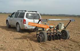
The Research Group in AgroICT & Precision Agriculture (GRAP) of the University of Lleida/ Agrotecnio-CERCA Center (Catalonia, Spain), is applying a technology that measures soil ECa using a device that georeferences the measurements using the European Geostationary Navigation Overlay Service (EGNOS), together with Sentinel-2 images (Copernicus Program) to identify drainage problems in some parts of the field, and therefore to understand the causes of crop development and yield variability.
A Veris 3100 Soil EC Surveyor (Veris Technologies Inc.) sensor system pulled by a tractor or other vehicle takes field measurements. A GNSS receiver mounted on the Veris unit records the location of each soil ECa measurement point in the field. The system is connected to an EGNOS-compatible GNSS receiver and performs continuous on-the-go measurements which allow obtaining an accurate ECa map, relating soil properties and yield. EGNOS contributes to georeferencing ECa measurements, producing an improved ECa map thanks to the submetric geolocation of sampled points. Therefore, the ECa map is very useful information to identify saline soils and the areas to extend the drainage network to improve soil conditions.
The information derived from the satellite was taken with Sentinel-2 (Copernicus), providing indicators of the state of the soils and crops, such as the Normalized Difference Vegetation Index (NDVI).
The following figures show apparent soil electrical conductivity (ECa) map taken, using EGNOS for georeferencing those points and the NDVI derived by Sentinel-2 image in an agricultural field crops (maize):
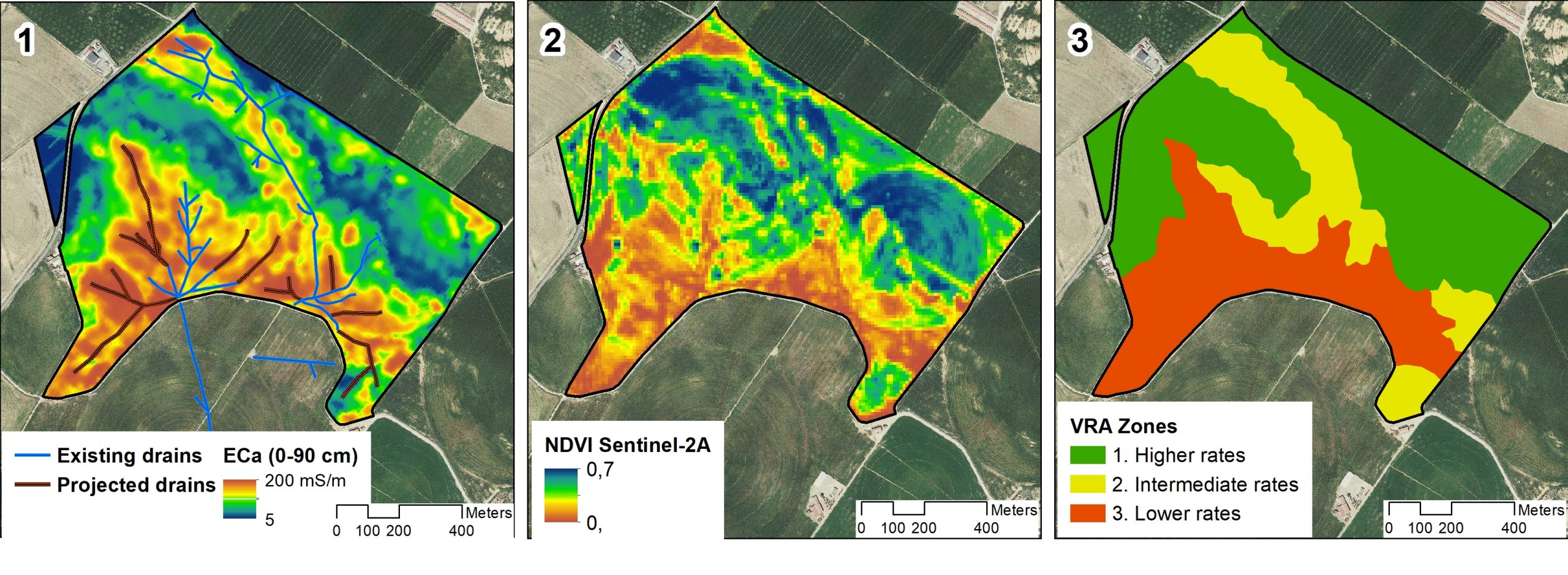
The ECa map (Fig. 1), shows that high ECa values (higher than 100 mS/m) corresponded to saline soils and to limited drainage, while low ECa values corresponded to soils with loam sand texture and with frequent gravel content. An NDVI map (Fig. 2) confirmed the findings of the ECa survey: the crops in saline soils and with bad drainage developed much less than in the areas with moderate to low ECa.
José Antonio Martínez-Casasnovas from GRAP says: “If the drainage systems had not been improved and organic modifications not been made, crop development and yields in the high ECa value areas would not have improved. Thanks to the ECa map improved with EGNOS and the information derived from Sentinel-2 it has been possible to increase the cost-benefit ratio of agricultural crops.”
In this particular case, the farmer increased the cost-benefit ratio by 11% with respect to the traditional uniform management.
The University of Lleida was the first university in Catalonia, founded in 1300.

 Revenue Generated in 2021")


