At last week’s EAA AirVenture in Oshkosh, Wisconsin, Garmin announced an expansion to its product line for the general aviation market including the GNC 355 GPS/comm.
Designed for Class I and Class II aircraft (weighing less than 6,000 pounds) and the experimental category, the GNC 355 fits between the new GPS 175 and the GNX 375 units in the Garmin product line-up. This latest GPS/comm adds the communications radio to the navigator found in the GPS 175, offering localizer performance with vertical (LPV) approach capability. The company expects the GNC to earn its supplemental type certificate soon and become available for shipping and installation.
Product features and capabilities include:
- Slim, all-in-one touchscreen GPS navigator and Comm radio for Part 23 Class I/II aircraft and experimental/amateur-built aircraft
- Take advantage of WAAS GPS navigation with LPV approaches, which offer minimums as low as 200’ to greatly expand operational capability
- Built-in 10W Comm radio with 25 kHz or optional 8.33 kHz channel spacing (with GNC 355A)plus standby frequency monitoring and automatic frequency identification
- Pairs with select Garmin flight displays, or integrates directly with your existing course deviation indicator (CDI) for cost-effective installation [See interfaces tab to verify compatibility.]
- Visualize your entire flight plan—including departures, arrivals, instrument approaches, holding patterns and more—on a rich, dynamic global moving map
- Wirelessly transfer flight plans and stream weather, traffic, GPS position and backup attitude via built-in Connext wireless technology to the Garmin Pilot™ app and more [A compatible datalink is required to stream traffic and weather.]
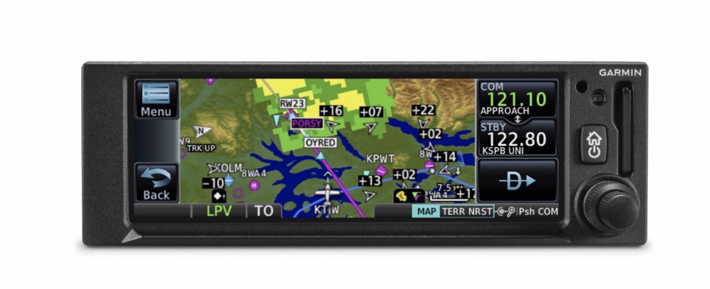
Big capabilities come in a small package with the GNC 355 navigator. With its bright, clear high-resolution touchscreen display, users can have advanced navigation functions along with modern comm radio capabilities. It’s equally at home in certificated aircraft or an experimental aircraft. And it’s the same 2” height as older navigation equipment and can allow you to keep the composite legacy CDIs already in your aircraft to minimize installation cost.
Perfect Touch
The moment you power up GNC 355, you’ll see a familiar Garmin homepage on the 4.8” display, which puts the most important functions within only a few touches. Navigate to dedicated pages for the moving map, traffic, terrain, nearest airports, flight plan, procedures, waypoint information, utilities and more. With shortcuts available to the flight plan and Direct-to functions on almost every page, navigation features are usually just a tap away. Use your finger to pan and zoom on any map, traffic and terrain page. Enter waypoint data with the on-screen keyboard. And touch the home button to get you back to the main page at any time.
For added control stability in flight, a shelf across the lower edge of the display serves to steady your hand in smooth and turbulent flight conditions. And if you prefer traditional controls, the concentric knobs provide yet another way to control many of the GNC 355 navigator’s functions.
Intuitive Navigation
With GNC 355, building and modifying flight plans is simple. As you enter waypoints, our FastFind feature automatically begins searching for the nearest identifier as soon as you start typing, so — in most situations — a press or two reveals just what you were thinking. You can also create holds, insert Victor airways and corresponding exit options and add departures, arrivals and instrument approach procedures. Additionally, you can edit your route using the map screen; a handy “rubber band” feature lets you grab any leg of your flight plan route and move it to accommodate a deviation or ATC amendment to your flight plan.
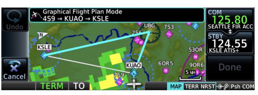
A variety of dynamically drawn and displayed maps provides situational awareness and context to the flight plan by highlighting visual reporting points, navaids, SafeTaxi diagrams and hazards such as obstacles, power lines and terrain. Plus, the Smart Airspace feature automatically highlights airspace close to your current altitude and de-emphasizes airspace away from the current altitude.
Advanced Approach to IFR
The SBAS/WAAS-certified GPS receiver can allow you to fly GPS-guided LPV glidepath instrument approaches down to as low as 200’, greatly expanding your operational capability. You can also access localizer performance (LP) and all area navigation (RNAV) approaches. Precise course deviation and roll steering outputs can be coupled to our GFC™ 500 and GFC 600 autopilots as well as select third-party autopilots so that IFR flight procedures such as holds, NextGen radius-to-fix (RF) legs and missed approaches may be flown automatically. In addition, the GNC 355 navigator lets you create and execute custom holding patterns over an existing waypoint or user-defined waypoint.


