Uncategorized Archives - Page 81 of 82 - Inside GNSS - Global Navigation Satellite Systems Engineering, Policy, and Design

Uncategorized

December 3, 2007

GNSS Hotspots | December 2007

One of 12 magnetograms recorded at Greenwich Observatory during the Great Geomagnetic Storm of 1859
1996 soccer game in the Midwest, (Rick Dikeman image)
Nouméa ground station after the flood
A pencil and a coffee cup show the size of NASA’s teeny tiny PhoneSat
Bonus Hotspot: Naro Tartaruga AUV
Pacific lamprey spawning (photo by Jeremy Monroe, Fresh Waters Illustrated)
“Return of the Bucentaurn to the Molo on Ascension Day”, by (Giovanni Antonio Canal) Canaletto
The U.S. Naval Observatory Alternate Master Clock at 2nd Space Operations Squadron, Schriever AFB in Colorado. This photo was taken in January, 2006 during the addition of a leap second. The USNO master clocks control GPS timing. They are accurate to within one second every 20 million years (Satellites are so picky! Humans, on the other hand, just want to know if we’re too late for lunch) USAF photo by A1C Jason Ridder.
Detail of Compass/ BeiDou2 system diagram
Hotspot 6: Beluga A300 600ST

1. CONFERENCE
√ Solar physicists met in Ethiopia in November for the Africa Space Weather Workshop. They had been monitoring the origin of coronal mass ejections – plumes of electrified gas – focusing on the geomagnetic equator, which passes over the sub-Sahara. With only a few dozen GPS geodetic receivers in Africa, conference organizers are trying to interest researchers in setting up hundreds more. They hope to be making real-time maps of the ionosphere over Africa within five years. Find out more about space weather and GNSS in this issue’s cover story.

Read More >

By Alan Cameron

GNSS & Space Weather

Space weather accounts for the most substantial errors experienced by GPS/GNSS systems and their users. It is the single largest contributor to the single-frequency GPS error budget, and a significant factor for differential GPS.

But exactly what is space weather? And how does it affect satellite navigation systems?

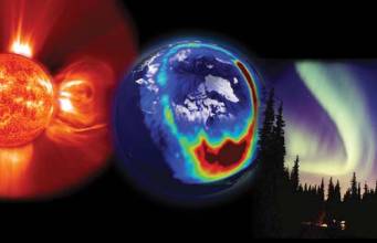
The solar wind has never blown anyone’s hat off, but it has literally destroyed electrical transformers and the electronic systems on satellites. Although space weather, except for the brilliant auroras, is invisible to the human eye, technologies can see it and feel its punch. As illustrated by the sidebar on page 34, (to view, download the pdf of this article using the link above) “December 6, 2006, Solar Eruption,” solar activity can have a very large effect on GNSS systems and users.

Increasingly, good predictions of space weather are ever more important to the GPS community as it strives to do more with the capability that GPS provides. This article describes some of the salient aspects of space weather, the scientific efforts being applied to monitoring and predicting it, and the resources available and under development to aid GNSS users in dealing with its adverse effects.

What is Space Weather?

A more or less official source — the National Space Weather Program Strategic Plan — defines space weather as “conditions on the sun and in the solar wind, magnetosphere, ionosphere, and thermosphere that can influence the performance and reliability of space-borne and ground-based technological systems and can endanger human life or health.” The National Space Weather Program consists of NASA, the National Science Foundation, and the U.S. Departments of defense, commerce, interior, and energy.

Adverse conditions in the space environment can cause disruption of satellite operations, communications, navigation, and electric power distribution grids, leading to a variety of socioeconomic losses.”

For GPS users, the salient part of the definition is the ionosphere, the variable plasma that exists from approximately 50 kilometers upward from earth’s surface. GPS signals, as they propagate from the satellite to the user, must pass through the ionosphere, and the ionosphere leaves its imprint on the signal the receiver finally “sees.”

This imprint may be either a signal with a time error or a signal that scintillates – “twinkles” – to such a degree that a receiver can’t track it. The time errors result in pseudorange errors, and the scintillations can cause a receiver to lose lock on the signal. Space weather drives the instabilities in the ionosphere, and these have varying time and spatial scales.

Solar Cycle

Data and observations over many years have shown that the Sun gives/takes the more spectacular types of space weather on roughly an 11-year cycle. At the height of the solar cycle, — the most recent maximum phase occurring during 2000-2001 — numerous eruptive events caused ionospheric storms that adversely affected GPS.

These events usually last for a few days and cause rapid changes in the amount and distribution of free electrons that affect the GPS signal as it propagates through the plasma. Think of the maximum phase of the solar cycle as being analogous to the hurricane season — it is a time of strong space weather activity with periodic pulses that have extraordinary impacts.

A more subtle but significant contributor to the solar cycle variability seen in the ionosphere is the fact that the Sun’s output in the extreme ultraviolet (EUV) wavelengths increases by a factor of four to five from solar minimum to maximum.

Literally, the Sun brightens and dims in its output of EUV, and EUV is the primary driver of photo-ionization in the middle ionosphere. The ionosphere is seen to “bulk up” when the Sun is providing more EUV, which increases the amount of free electrons that, in turn, affect the GPS signal.

Currently Solar Cycle 23 is near its end and in a minimal state of activity. Signs of the beginning of the new cycle are anxiously anticipated. The solar EUV flux is low, eruptive events are rarely occurring, and the ionosphere is well-behaved for GPS users.

What is the latest prediction for the likely character of the coming solar cycle, Cycle 24? A blue-ribbon group, the Solar Cycle 24 Prediction Panel — convened by NOAA, NASA, and the International Space Environment Service (ISES) — has had serious, lively deliberations aimed at predicting the magnitude of the next solar cycle. As of this writing, the panel is split.

The reasons for the divergence of opinion are very interesting. One faction of the prediction panel argues that the seed magnetic flux available for Solar Cycle 24 is found by measuring the strength of the solar polar magnetic fields. (According to this perspective, the “seed” population will then evolve to become sunspots for the next cycle.)

This first faction argues that the magnetic fields will be drawn into the solar interior and percolate to the surface in the next few years as sunspots, which provide the prime metric by which solar cycles are measured.

Indeed, the solar polar fields over the past 30 years show a relationship between the strength of the solar polar magnetic fields and the magnitude of the next solar cycle.

If a cause and effect relationship exists in these data, a prediction of a small Solar Cycle 24 is clearly reasonable, given that the solar polar fields were very weak at the appropriate phase of the current solar cycle, around 2005.

On the other hand, a dissenting faction of the prediction panel believes that a different metric provides a more relevant and necessary observable for foretelling the size of the next solar cycle. That metric is the strength of the meridional flow seen at the solar surface, over the time period of the past two solar cycles. This meridional flow is the movement of magnetic flux from low solar latitudes to the polar regions, supplying the new cycle’s magnetic field with which to work.

In effect, this latter group postulates that the Sun has a “memory,” and knowing what has recently occurred will indicate what is soon to come. What is most intriguing about this new model is that it has faithfully replicated the past eight solar cycles. (For a further discussion of this model, see the publication by M. Dikpati et al listed in the Additional Resources section at the end of this article.)

If the meridional flow model truly captures the relevant physics, then a prediction of Solar Cycle 24 being 30–50 percent larger than Solar Cycle 23 is reasonable; hence, the debate within the scientific community.

The GPS community needs to know how Solar Cycle 24 will play out: a strong cycle bodes for more ionospheric storms in the context of a “bulked up” ionosphere. A weak cycle means fewer ionospheric storms against a backdrop of a more svelte ionosphere.

NOAA Products for GPS

The National Oceanic and Atmospheric Administration (NOAA) has made a variety of space weather products — including near-real-time total electron counts — available to the GPS/GNSS user community. These are developed and produced at the Space Weather Prediction Center (SWPC) in Boulder, Colorado.

The SWPC is a component of the National Centers for Environmental Prediction (NCEP) of NOAA’s National Weather Service (NWS). SWPC includes a 24/7 Space Weather Forecast Office that provides alerts, warnings, watches, and appropriate products to a varied user community, both nationally and internationally.

The SWPC is designated as the World Warning Agency for space weather of the International Space Environment Service (ISES). This organization works under the auspices of the International Council of Science (ICSU) and is comprised of 12 member nations and the European Space Agency.

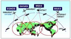
In addition to GPS, development of other satellite constellations — GLONASS (Russian Federation), Galileo (Europe), Quasi-Zenith Satellite System or QZSS (Japan), and Compass (China) among others — have raised awareness of the international GNSS community’s need to know the condition of the ionosphere — space weather — that affects their own GNSS system. Space weather is the common thread that stitches together all of the GNSS and augmentation systems. The ionosphere must be dealt with.

Within NOAA, several agency partners contribute to the space weather products. The National Geodetic Survey’s Continuously Operating Reference System (CORS) makes the real-time measurements of the ionosphere used by SWPC’s data assimilation model. The National Geophysical Data Center (NGDC) operates the infrastructure over which these measurements flow to SWPC with minimal time latency.

The expertise and measurements of the Global Systems Division (GSD) of the Earth System Research Laboratory (ESRL) contributed to SWPC’s development of its ionospheric product derived from GPS observables. GSD extracts precipitable water vapor estimates for the benefit of terrestrial weather users.

As the result of this cooperative effort, space weather products for GPS are available from SWPC. Figure 4 presents an example of the United States Total Electron Content (US-TEC) product (Figures available only in the pdf of this story. Download it at the site indicated, right below the headline). It shows North America, with contours of TEC. This graphic illustrates typical solar minimum conditions with values ranging from less than 5 to more than 30.

The symbols on the map in Figure 4 represent the measurements incorporated into the data assimilation, numbering 99 in this example. Data contributors are NOAA CORS, NOAA GSD, and the International GNSS Service (RTIGS). The US-TEC product is produced every 15 minutes and available on line at http://www.swpc.noaa.gov/ustec/index.html.

The value of US-TEC lies in its ability to quickly show GPS users where areas of high gradients — multi-colored swaths on the map – and high values exist. The gradient structures may affect some receiver’s ability to lock onto signals, while high values may cause single-frequency users to experience unexpected positioning errors.

The current version of US-TEC is a specification of the conditions that existed approximately 30 minutes ago. That latency is a result of data collection, transmission, and model processing time.

The ideal situation would be an ability to forecast the conditions to occur in the ionosphere. The plan of the SWPC – and appropriate to the “prediction” verb in the center’s title – calls for the timely issuance of forecasts of space weather conditions that will provide practical value to GPS users.

One other planned improvement is to identify the highest gradient structures for the user community. Figure 5 shows a gradient or slant delay observed over North America during the November 20, 2003, ionospheric storm.(Figures available only in the pdf of this story. Download it at the site indicated, right below the headline)

The US-TEC product improvements include an ability to find these “walls” of TEC and alert users of their existence and potential effects on their operations.

NOAA is both a provider and user of GPS products and services. SWPC is an example of the duality of that relationship. SWPC uses the GPS data it receives through NOAA and IGS to produce US-TEC, which is then provided to the external user community.

As the chartered provider of space weather services in the United States, SWPC strives for products that enable users to see what can’t be seen —the overhead ionosphere.

Future Users

GPS has been described as a “fourth utility” after heat, electricity, and water. It is so ingrained into the daily habits of many consumers that the absence of satellite navigation services would be seen as an unmitigated disaster.

Countless applications exist that were barely foreseen 25 years ago. Personal positioning services, ranging from the commercial “where to shop” to the critical safety-of-life applications, bound the spectrum of uses. The demands to know one’s location and the location of others seem endless. Consequently, the bar has been raised for space weather service providers if they are to keep pace with the needs and expectations of users.

Space weather services must rise to the challenge. Better predictions of the state of the ionosphere, including days-ahead forecasts that begin with a forewarning of a solar eruption, are a desirable goal, however difficult that may be to achieve. Particular applications have been identified that will have very stringent requirements for the user community.

The Federal Aviation Administration (FAA) plans to deploy an aircraft management system called automatic dependent surveillance – broadcast (ADS-B). This somewhat unwieldy acronym refers to a system that would enable aircraft to communicate and locate each other within the airspace, relying less on ground-based radar and more on space-based satellite navigation.

ADS-B will allow pilots greater situational awareness, enabling them to fly at safe distances from one another with less assistance from traditional air traffic controllers. It has been labeled a crucial component of the Next-Generation Air Transportation System, or NextGen. A core technology for the proper function of ADS-B is GPS.

Finally, another application that is experiencing growth and development is the ability to locate cell phone transmissions during an emergency, a procedure that the Federal Communications Commission refers to as automatic location identification. In the United States this has been dubbed E911; the European analog is E112.

One of the means cellular operators may implement to locate an E911 caller is to use an embedded GPS chip in the cell phone, allowing a location to be determined and transmitted automatically to an emergency service provider.

Conceivably, the requirement for E911 positioning accuracy may increase as users and providers need to reach the site of an emergency more quickly. If steps are not taken to detect and avoid the effects of adverse space weather, it could seriously interfere with the success of this safety-of-life application.

Conclusions

Space weather is mostly invisible to the human eye, but at times a blinding beacon to GPS/GNSS systems. It is a major contributor to GPS error budgets, and can, with little warning, cause total loss of one’s ability to use GPS or other GNSS systems.

Space weather has both a cyclical component as well as a spontaneous component. A great debate is now taking place about the likely characteristics of the upcoming Solar Cycle 24.

Be it large or small, events such as the one seen on December 6, 2006, do occur and can dramatically affect GPS operations. The NOAA SWPC is in close consultation with the GPS user community, to design and produce products and services, in cooperation with other partner organizations with NOAA. There’s no other route – to improve GPS services it requires improved space weather products and services.

Additional Resources

Dikpati, M., G. de Toma, and P. A. Gilman, “Predicting the strength of solar cycle 24 using a flux-transport dynamo-based tool,” Geophysical Research Letters, 33, L05102, doi:10.1029/2005GL025221, 2006
Goodman, J. M., Space Weather and Telecommunications, Springer, 2005
“National Space Weather Program Strategic Plan, FCM-P30-1995,” Washington, D.C., Office of the Federal Coordinator for Meteorology, http://www.ofcm.gov/nswp-sp/text/a-cover.htm
Poppe, Barbara B., and Kristen P. Jorden, Sentinels of the Sun, Johnson Books, 2006

By
November 2, 2007

GNSS Hotspots | November 2007

One of 12 magnetograms recorded at Greenwich Observatory during the Great Geomagnetic Storm of 1859
1996 soccer game in the Midwest, (Rick Dikeman image)
Nouméa ground station after the flood
A pencil and a coffee cup show the size of NASA’s teeny tiny PhoneSat
Bonus Hotspot: Naro Tartaruga AUV
Pacific lamprey spawning (photo by Jeremy Monroe, Fresh Waters Illustrated)
“Return of the Bucentaurn to the Molo on Ascension Day”, by (Giovanni Antonio Canal) Canaletto
The U.S. Naval Observatory Alternate Master Clock at 2nd Space Operations Squadron, Schriever AFB in Colorado. This photo was taken in January, 2006 during the addition of a leap second. The USNO master clocks control GPS timing. They are accurate to within one second every 20 million years (Satellites are so picky! Humans, on the other hand, just want to know if we’re too late for lunch) USAF photo by A1C Jason Ridder.
Detail of Compass/ BeiDou2 system diagram
Hotspot 6: Beluga A300 600ST

1. GOVERNMENT ACTION
President Bush has announced an end to Selective Availability (SA), the intentional degrading of open GPS civil transmissions. In a September 18 statement, Bush said he was adopting the recommendation of defense officials to eliminate the SA capability on future generations of satellites (see story in this issue).

Read More >

By Alan Cameron
[uam_ad id="183541"]
October 31, 2007

Location India 2008

This BtoB conference and exhibition includes three seminars on positioning technology for fleet management, location based services, and vehicle navigation. Technical sessions also cover locational intelligence, business GIS, emerging technologies, agricultural applications, and marine vessel management.

The event takes place in the India Expo Center in the planned community of Greater Noida, near Delhi. The conference hotel is Radisson Hotel Noida.

Read More >

By Inside GNSS
October 22, 2007

Envisioning a Future: GNSS System of Systems, Part 1

We have just made the transition into the new year of 2007. Most of us probably already have our eyes focused onto the next 12 months along with some wishes and perspectives that we would like to have fulfilled in the coming 365 days.

We have just made the transition into the new year of 2007. Most of us probably already have our eyes focused onto the next 12 months along with some wishes and perspectives that we would like to have fulfilled in the coming 365 days.

In the same spirit, over the next two issues of Inside GNSS this column will take a look into the near future and — what is even more exciting — into the further future of satellite navigation. But what that future will look like depends to an enormous extent on what the past was; so, we should have first a look back into the roots of GNSS.

Long ago the Americans entered the global navigation satellite system (GNSS) era with the Global Positioning System (GPS) as the result of efforts that began in the late 1960s. The Russians followed soon afterwards (or did they do it in parallel?) with GLONASS. Both of these systems are now undergoing extensive modernization. Moreover, the European Galileo system is joining the GNSS club, and China is now planning its own version called Compass.

In the meantime lots of augmentation and regional systems have been developed or are currently under consideration. From military to civil signals, from medium Earth orbit (MEO) to geostationary Earth orbit (GEO) and inclined geosynchronous orbits (IGSO), the palette of systems and offered services is as wide as imagination allows.

Is it not time, therefore, to pause and think for a moment about where we want GNSS to move? Is it not already time to really “think global” and to coordinate and harmonize all the existing and projected navigation satellite systems? If so, then the question naturally arises: what should the “Global Navigation Satellite System of Systems” look like?

This column will try to shed some light on the fascinating new world of GNSS in which we will live around the year 2020 if all the currently modernizing and planned new systems come into reality. It will be a complex world where the word “coordination” will be the key and from which, if we do it right, users will be the ones that will profit the most. After all, why should a GNSS user really care about whether one of his or her signals comes from GPS, the other from Galileo, the third from GLONASS and the fourth from Compass as long as the GNSS receiver works well?

Scenes from the Present

Today only GPS is fully operational. Nevertheless, Russia hopes to return GLONASS to full operation capability (FOC) with a completed constellation by 2009, and Galileo’s FOC is now expected in 2012. Compass is already knocking on the door, and in spite of the fact that China has still a long way to go and lengthy negotiations will be needed, a scenario of four global coverage satellite systems seems to be very likely in a future not so far away from today.

From the experience with Galileo, we know how important the roles of interoperability and compatibility with GPS were from the very beginning. Unfortunately, major differences between those two systems and GLONASS still exist.

However, also on the GPS/GLONASS side, work on attaining real interoperability is continuing. Just recently during the GPS/GLONASS Working Group 1 meeting in December 2006, both sides emphasized the benefit to the user community that a common approach concerning FDMA/CDMA would bring in terms of interoperability. The Russian side announced that they will come to a decision on adding or converting to a CDMA format by the end of 2007. The formal U.S.-Russia statement can be viewed at
<http://www.glonass-ianc.rsa.ru/i/glonass/joint_statement_eng.pdf>.


The direction in which COMPASS will go remains a large unknown. In fact, if the need of standardization was always there, it seems that the concept is gaining in interest the more systems come into play.

But before dreaming with our ideal GNSS, let us first look more closely into what the current reality is and what the plans for new GNSS systems are.

(For the rest of this story, please download the complete article using the PDF link above)

By
October 20, 2007

GNSS for the Masses

Oh, yes, to be sure — they are really impressive numbers: the steep upward curve of unit and dollar (or euro or ruble or renminbi) sales volumes now that GNSS has hit the big time.

Whether it’s $25 billion today or $68 billion in 2010, the worldwide market has really taken off since consumers have discovered — almost by accident, in many cases — the amazing power of GNSS-driven products and services.

Ah, consumers. The mass market.

Rich! We’ll all be rich beyond our wildest imaginings!

Sometimes this new-found excitement about size brings to mind the character played by Danny DeVito in the movie “Twins,” who is told what will be paid for some stolen property that he has accidentally gotten hold of.

“Five million dollars,” his says in disbelief. “Five million dollars.”

Only we’re talking billions here. Even if we’re not exactly sure how many billions, because everybody seems to count the GNSS value-add differently.

At a certain point the situation becomes like the chain of restaurants that used to post its cumulative total of hamburger sales on the outlet signs. Eventually, the company just started saying, “Billions and billions served.” But before we get swept away by all the geocaching and friend-finding and child-tracking, let’s take another look at that value chain leading to the mass market.

Fabrication technology delivers some amazing results — no question about it. But the distinctive value of GNSS is not to be discovered in the foundries of Taiwan or China. Rather, it arises from the imaginations and hard work of engineers and signal designers around the world.

Last time I checked, silicon, germanium, etc. were still inorganic substances. But it’s the organic life-forms – more, the intelligence behind the life-forms — that brings the engineering value to GNSS consumer products. It’s not how fine you etch the lines on ever-thinner slices of silicon; more important are the algorithms that drive the electrons along those circuits.

In other words, silicon is the clay, not the potter.

As Intel has pointed out for years, it’s what goes in before the plastic goes on that makes the difference in a product. Better algorithms mean reduced instruction sets, which mean fewer gates, smaller components, and lower bills of materials. Only then do the GUIs and LCDs begin to make sense.

So, if silicon isn’t really where the value lies, where is it? Fundamentally, we can trace that value chain back to signal processing and software. Software for applications, and signal processing with which to define and drive the products.

Behind the signal processing, of course, lie the signals themselves. That’s where the digital gold rush truly begins. And the world’s providers of GNSS signals are opening up the mine fields.

GPS, GLONASS, Galileo, and probably Compass are bringing dozens (if you count the data and pilot channels separately) of new and better signals to the marketplace, particularly in those portions of the RF spectrum favored by designers of consumer products.

That means before we can get to the glitz and glamour of retail GNSS — the concept stores, the lovely models laden with PNDs — engineers will have to pass through new labyrinths: the equations, the computations, the schematics, the bench tests, the field trials, the prototypes, and all the rest.

Yes, it’s true. GNSS is now for the masses. And yet, before the tabulation must come the innovation.

glen@insidegnss.com


By Inside GNSS

A System of Systems

Cruising around out here in Oregon, far outside the D.C. Beltway on the golden sunset side of the American dream, listening to the radio, I realize I have a little signal availability problem of my own sometimes.

Cruising around out here in Oregon, far outside the D.C. Beltway on the golden sunset side of the American dream, listening to the radio, I realize I have a little signal availability problem of my own sometimes.

As I head home to Eugene after visiting a few produce stands out in the country, my favorite classic rock station over in Corvallis begins to fade in and out. The backup station of choice is coming in strong — but it’s pumping out a marathon set of advertisements. Finally, I reach my fallback — a public radio station at the local high school, and we’re back in the groove.

Coming back from the recent Institute of Navigation conference in Fort Worth, Texas, I reflect once again on how happy I’m in the GNSS business, and that GPS is getting some company out there in space. Because, great as the Global Positioning System is — and it’s been great for the past 18 years at least — it’s time the system had some backup (and that other national budgets began carrying some of the financial weight, too).

Robustness, redundancy, availability, interoperability. Like FM radio, these are the qualities that make a GNSS system of systems such a desirable goal — for GNSS product manufacturers and location services providers, for end users, and for the nations building critical infrastructures and national security policies on space-based positioning, navigation, and time.

The recent ION GNSS event underlined just how vigorously that goal is being pursued around the world.

On Monday before the conference’s opening, the U.S. Air Force reported a successful launch of the second modernized GPS Block IIR satellite with new military and civil signals and announced another launch in November. Meanwhile, program officials were waiting patiently to hear Europe’s decision on whether BOC (1,1) or multiplexed BOC signals would become the common L1 civil signal waveform for future GPS and Galileo satellites.

From Russia we heard of a new commitment to bring a modernized GLONASS system on line rapidly, to expand it to embrace true civil and commercial utility, and — mirabile dictu! — to consider adding CDMA signals to its basic FDMA transmissions. And, remember, over the past three years, GLONASS is the only GNSS system that has delivered its satellites into space as scheduled.

Finally, European officials, public and private, expressed a new responsiveness to widespread pressure to release Galileo’s open-service signal specs to commercial development – without licensing fees, favoritism, or other foolishness. Not a done deal, by any means, but certainly a nod in the right direction.

In these developments, we can see the beneficial effects of having multiple systems jostling for the limelight. Like celestial bodies in motion around one another, they manifest a gravitational pull. Indeed, the emergence of GNSSes (plural) has demonstrated an institutional version of Newton’s First Law. No longer can those bodies remain at rest, or undisturbed on courses defined only by their own motion.

Yes, GPS is still the system in this GNSS system of systems. Still the king of kings, the shahinshah, the capo di tutti capo. But this element of American exceptionalism is waning, as Galileo and GLONASS wax ever more confidently — to the betterment of all three and the benefit of a world in which the GNSS utility is making a permanent home.

A system of systems and each, a system among systems.

glen@insidegnss.com


By Inside GNSS
[uam_ad id="183541"]

Turning Point

Historians sometimes speak of the Axial Age, referring to an ancient era that saw the coincident appearance of major religious and philosophical movements in widely scattered regions of the world. It represented a turning point in the course of human affairs.

This first decade of the 21st century may prove to be the Axial Age of the Global Navigation Satellite System (GNSS) community. Consider these signs and portents:

The U.S. Global Positioning System is poised to regain its momentum and sense of direction.

Russia’s GLONASS system is showing a sustained and growing resurgence.

And Europe has launched GIOVE A, the first prototype spacecraft for a 30-satellite constellation scheduled to come on-line over the next few years.

Regional augmentation systems adding accuracy and navigation signals to the basic GNSSes are being built by the United States, Europe, India, and Japan. And we may still not have seen the last of the full-fledged GNSSes, if reports of China’s continuing interest in building its own system prove true.

Until now, positioning has been a lot like the weather: everybody talked about it, but nobody did anything about it. They couldn’t — not practically, not without affordable, accessible tools and the techno-cultural sensibilities to bring it about. It was as though we were talking about time before the advent of the pocket watch.

Part of this situation arises from the human psyche itself: we usually have this innate and immediate sense of where we are and where we’re going. We may even think we know where the kids are. So, why would we ever need a positioning device, whatever that is?

And yet, these are highly subjective and relative sensibilities. It’s the locational equivalent of telling time by looking at the sun or trying to recall whether the last round of cathedral bells called out Matins or Lauds.

Of course, despite appearances, all time is relative (or perhaps not), if only in relationship to the excitations of a cesium atom. So, too, is location, which depends on a map datum to sort out the places from the spaces, or positioning, which uses mathematical strategems to make sense of the folly of the geoid. And those constructs have beginning points and terms of reference that are thoroughly conventional, not divine.

Slowly, steadily, but with an ever-growing momentum, GNSS-driven applications of accurate time and location are entering the popular imagination. Today, hundreds of millions of people are walking around with GPS receivers in their pockets — whether they know it or not. And literally billions are benefiting from the myriad uses to which the technology is being put.

Yes, the portals may be swinging open to a land of milk and honey for GNSS manufacturers, engineers, and users. And, then again, maybe the doors will swing shut again.

All three systems have reached a kind of unsteady equilibrium, a balance of the forces driving them ahead and those that would slow them down or drive them aside from their charted courses. The way ahead is neither predestined nor foretold. It will depend upon the energy, attention, skills, and motives of many people around the world.

Nonetheless, having spent the past 16 years chronicling the adventures of the GNSS community, I enter this era with more hope and expectation than ever about the prospects for this amazing utility. I believe that we are at a historic turning point in technology.

This magazine, then, will serve as a vehicle for carrying the continuing story of this community into a new phase, a new age of GNSS.

glen@insidegnss.com


By Inside GNSS
September 26, 2007

International Symposium on GPS/GNSS 2008

An annual conference that rotates among countries in the Asia-Pacific region, the International Symposium on GPS/GNSS 2008 will be held at the Tokyo International Exchange Center (TIEC).

It is organized by the GPS/GNSS Society of the Japan Institute of Navigation and hosted by Tokyo University of Marine Science and Technology.

Read More >

By Glen Gibbons
September 21, 2007

GSM Mobile World Congress 2008

The Mobile World Congress (formerly 3GSM World Congress) combines the world’s largest exhibition for the mobile industry – mobile operators, content owners, and vendors from around the world –  with a conference where CEO- and board-level speakers will discuss industry issues and trends. It will take place at Fira de Barcelona-Montjuic, a convention complex in a historical district of the city.

The event is sponsored by GSMA, the mobile phone operators trade association. 

Read More >

By Inside GNSS
September 18, 2007

Seventh Symposium on Frequency Standards and Metrology

Forum on advanced clocks and oscillators, and their applications in science and metrology. It brings together those engaged in the development of precise frequency standards and clocks, the study of their underlying physics, and their applications in metrology and tests of fundamental laws.

The conference began in 1971 and is held every seven years. It is organized around single sequential sessions with oral presentations on each topic plus poster sessions. It will include keynotes by internationally recognized speakers and social events.

Read More >

By Inside GNSS
September 16, 2007

ION NTM 2008 — Institute of Navigation National Technical Meeting

Exploring Future Uses of Navigation Technology

The Institute of Navigation’s 2008 National Technical Meeting will focus on how the existing sources of navigation technology will be enhanced to provide improvements to the user community. This community will include everyone from civilians using a Global Navigation Satellite System (GNSS) to improve their commute to work, to astronauts using a new planned navigation architecture to complete a permanent presence on the moon and then venture on to Mars.

Read More >

By Glen Gibbons
IGM_e-news_subscribe