Timing on the Fly
Sensor fusion is a predominant feature of modern navigation systems. To integrate navigation systems with other sensors, the spatial and temporal relationship of the sensor systems must be defined and calibrated.
ByGlobal Navigation Satellite Systems Engineering, Policy, and Design
Sensor fusion is a predominant feature of modern navigation systems. To integrate navigation systems with other sensors, the spatial and temporal relationship of the sensor systems must be defined and calibrated.
By
Since the dawn of humanity, the sky and stars have stimulated our imagination and curiosity. As our understanding about outer space increases, so does our passion and drive to explore beyond the reaches of our own planet — and to use space to understand our own planet.
By
Rome wasn’t built in a day, and neither was the Global Positioning System.
Nor will the emerging GNSS system of systems arising from the regional and global infrastructures being put in place or modernized today: GPS, GLONASS, Galileo, Compass (Beidou-2), QZSS, GAGAN, IRNSS, EGNOS, WAAS, MSAS, and undoubtedly other acronyms yet to be born.
By
 One of 12 magnetograms recorded at Greenwich Observatory during the Great Geomagnetic Storm of 1859
 1996 soccer game in the Midwest, (Rick Dikeman image)
 Nouméa ground station after the flood
 A pencil and a coffee cup show the size of NASA’s teeny tiny PhoneSat
 Bonus Hotspot: Naro Tartaruga AUV
 Pacific lamprey spawning (photo by Jeremy Monroe, Fresh Waters Illustrated)
 “Return of the Bucentaurn to the Molo on Ascension Day”, by (Giovanni Antonio Canal) Canaletto
 The U.S. Naval Observatory Alternate Master Clock at 2nd Space Operations Squadron, Schriever AFB in Colorado. This photo was taken in January, 2006 during the addition of a leap second. The USNO master clocks control GPS timing. They are accurate to within one second every 20 million years (Satellites are so picky! Humans, on the other hand, just want to know if we’re too late for lunch) USAF photo by A1C Jason Ridder.
  Detail of Compass/ BeiDou2 system diagram
 Hotspot 6: Beluga A300 600ST

1. GOOD-BYE DELTA II
. . . It’s been good to know you!
Cape Canaveral, Florida USA
√ The last of eight modernized GPS IIR-2R (M) satellites is in its place in the constellation, carried to its spot on August 17 by the last of the U.S. Air Force’s United Launch Alliance Delta II rockets. For 21 years, they’ve been the GPS ride.

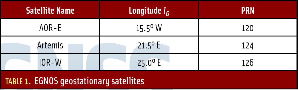 Table 1: EGNOS geostationary satellites.
Some GPS applications generate long time series of position estimates. Most often, an easy way of getting a quick overview on the recorded data is to plot them. However, it may be difficult from a plot to quantify statistical measures such as mean value, standard deviation, and circular error probable (CEP).
By
Return to main article "Signal Authentication"
By
