Uncategorized

Officials Delay First GNSS Authorization Request; Light-Squared Tries to Leverage Issue

The U.S. stance on satellite navigation has long supported international cooperation and a degree of interoperability. In 2010 the Obama administration even adopted a space policy that said foreign satnav services could be used “to augment and strengthen the resiliency of GPS.”

That was easier in the abstract, however, when the only fully functional GNSS was GPS. Now, with other GNSS services coming online, American officials want to think things through again.

Read More >

By Dee Ann Divis

ESA and EC at Odds (Again) over Space Governance

Reporting from Brussels last year, we explained that the then–brand new EU GNSS Regulation had effectively put to bed years of wrangling over who does what in Europe’s GNSS programs. But the issue reared its head again in Brussels recently, in a highly charged discussion hosted by the European Economic and Social Committee (EESC).

Read More >

By Peter Gutierrez
[uam_ad id="183541"]
[uam_ad id="183541"]

Playing by the Rules of World Trade Law

The availability of several GNSSes promises advanced positioning, navigation, and timing services with higher availability and improved accuracy. According to a European GNSS Agency (GSA) market study, nearly 60 percent of receivers, chipsets, and modules already support at least two GNSS constellations, showing that multi-constellation is becoming a standard feature across all market segments. That development brings up questions of law and regulation that require careful handling by GNSS manufacturers, service providers, and policy makers.

Read More >

By Ingo Baumann

Software-Defined GNSS Simulator: A Step Forward

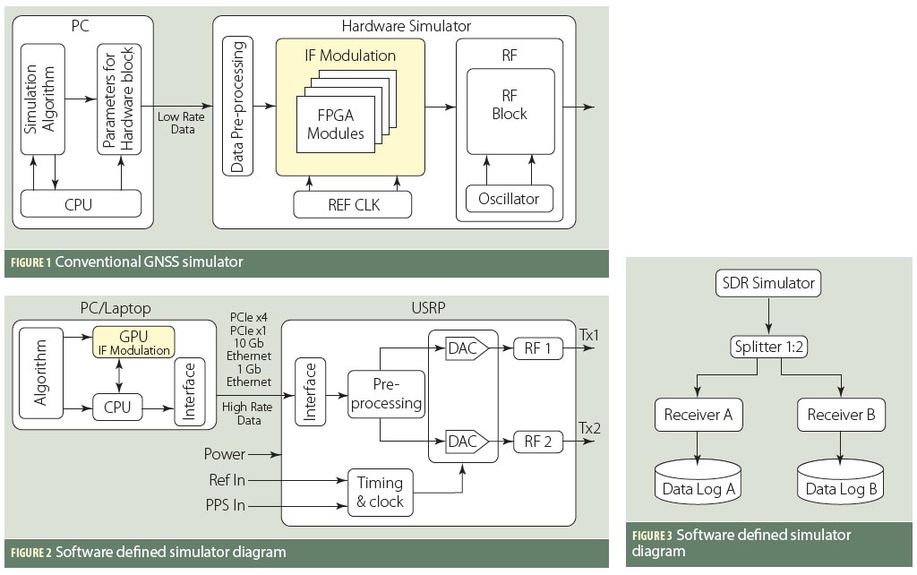
A few studies (by universities and industry) have shown the feasibility of simulation of real-time digital intermediate frequency (IF) signals based on a graphics processor unit (GPU). And a couple of articles have also demonstrated use of a universal software radio peripheral (USRP)–based software-defined radio (SDR) as a simulator (in playback mode) in real test environments.

Read More >

By Inside GNSS

First Position Fix with IRNSS

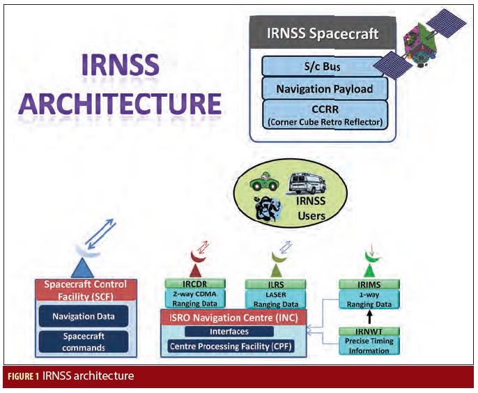
The Indian Regional Navigation Satellite System (IRNSS) is an Indian Space Research Organisation (ISRO) initiative to build an independent satellite navigation system that provides precise position, velocity, and time (PVT) to users across the Indian region.

The primary objective of IRNSS is to achieve position accuracy of 20 meters (2σ) for dual-frequency users over India and the primary service area (a region extending to about 1,500 kilometers or 930 miles).

Read More >

By Inside GNSS
1 17 18 19 20 21 82
IGM_e-news_subscribe