legacy-application Archives - Page 8 of 14 - Inside GNSS - Global Navigation Satellite Systems Engineering, Policy, and Design

legacy-application

June 30, 2011

USA Challenge Competition Seeks Satellite Navigation Apps

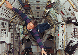
This is a 1993 photo of Walter, a German astronaut. He exemplifies the fearless approach to experimentation and the spirit of fun that we are looking for (DLR photo)

[Updated June 30] Lucky you – you have three extra days to submit your GNSS application idea to the USA Challenge! The extended deadline is midnight Sunday (Europe) or 3 P.M. (Pacific time) on July 3.

Right now, some team is hard at work in a basement, an office, a dorm room or a lab. They are about to come up with a new, useful and commercially viable idea for a satellite navigation application or location based service.

Read More >

By Inside GNSS
May 15, 2011

GPS Technology and People Behind Gravity Probe B’s Einstein Relativity Experiment

NASA’s May 3 announcement that its long-running Gravity Probe B (GP-B) mission had confirmed two key predictions derived from Albert Einstein’s general theory of relativity, mentioned GPS autoland techniques as one of the projects spinoffs.

However, the involvement of GPS technology and GPS experts in the mission was much deeper than the passing reference in a press release.

But first, the news.

Read More >

By Inside GNSS
[uam_ad id="183541"]
April 30, 2011

Air Traffic Control Modernization: FAA, NextGen, GNSS, and Avionics Equipage

Mike Dyment, General Partner, NextGen Equipage Fund LLC

» Air Traffic Control Modernization (PDF)

In between partisan confrontations around the 2011 federal budget and raising the U.S. debt limit, prospects are improving for federal legislation that would provide the Federal Aviation Administration (FAA) with a regular full-year budget for the first time since Fiscal Year 2007 — including support for completing the transition to a GNSS-driven air traffic control (ATC) system known as NextGen and a “public-private partnership” to equip aircraft with the needed avionics.

Read More >

By Inside GNSS

New Senate Subcommittee Addresses Mobile Technologies and Privacy: Apple, Google to Appear

Funny thing about the U.S. Constitution: it address the activities of government officials and agencies — including restraints on those activities — but not the activities of commercial business and individuals. The latter are left to federal, state, and local laws.

So, when the government conducts warrantless surveillance using GPS, the issue may come before the U.S. Supreme Court or state and federal judges at other levels. If private companies do it, they may end up at a congressional hearing.

Read More >

By Inside GNSS
April 26, 2011

10 High School Teams to Test Robots at the Smithsonian in the 2011 Mini Urban Challenge

Pace High School “Catastrophic” team, the 2010 winner

Ten Lego kits transformed into autonomous robotic vehicles will gather, with their high school student masters, on Saturday, May 21 at the Smithsonian for the 2011 national championship of the Institute of Navigation Mini-Urban Challenge.

It all happens from 8 a.m. to 5 p.m. in the Spark!Lab and first floor of the Lemelson Center for the Study of Invention and Innovation on the National Mall.

Read More >

By Inside GNSS
[uam_ad id="183541"]
April 23, 2011

GPS-Guided Honeywell MAV Aids in Japan Nuclear Plant Emergency

T-Hawk MAV. Honeywell photo

A GPS-guided T-Hawk Micro Air Vehicle (MAV) more frequently used in combat reconnaissance missions in Iraq and Afghanistan is being used to help emergency efforts at Japan’s damaged fukushima Daiichi nuclear plant.

Weighing just 17 pounds and measuring 14 inches in diameter, the T-Hawk is a ducted-fan vertical takeoff and landing air vehicle originally developed in recent years by Honeywell Corporation under a $40-million Defense Advanced Research Projects Agency (DARPA) technology demonstration contract.

Read More >

By Inside GNSS
April 12, 2011

NavCom Introduces Multi-GNSS SF-3040 Receiver

NavCom Technology’s SF-3040 Receiver

NavCom Technology, Inc., has launched its 66-channel, SF-3040 pole-mount receiver, featuring StarFire/real-time kinematic (RTK) multi-GNSS capabilities and optimized for surveying and mapping applications.

NavCom says its new product provides real-time kinematic (RTK)–level accuracy up to 40 kilometers away from the base station or decimeter-level accuracy anywhere in the world when using the company’s StarFire global satellite-based augmentation system (GSBAS).

Read More >

By Inside GNSS
March 14, 2011

GNSS Inside Mobile Phones

Figure 1 & Table 1

For the complete story, including figures, graphs, and images, please download the PDF of the article, above.

Recent years have seen GPS receivers built in as a standard feature in many consumer products. A growing number of mobile phones, personal navigation devices, netbooks and tablets are equipped with GPS receiver chips and navigation software that enable consumers to navigate from A to B or find their nearest coffee shop. According to Berg Insight, annual shipments of GPS-equipped mobile phones are estimated to reach 960 million devices in 2014.

Read More >

By Inside GNSS
1 6 7 8 9 10 14
IGM_e-news_subscribe