Magazine Section Archives - Page 60 of 66 - Inside GNSS - Global Navigation Satellite Systems Engineering, Policy, and Design

Magazine Section

A Model-Based Approach

For the complete story, including figures, graphs, and images, please download the PDF of the article, above.

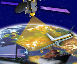
Galileo receiver designers require formal interface specifications for the Galileo signal-in-space (SIS) in order to write unambiguous and accurate specifications for Galileo receivers. To compute their positions, Galileo receivers must be able to retrieve timing and orbital information from the data stream conveyed in Galileo analog signals.

Read More >

By Inside GNSS
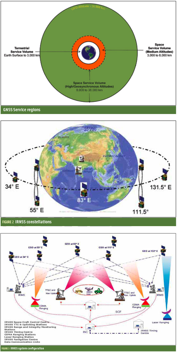
Indian Regional Navigation Satellite System

FIGURES 1, 2 & 3

For the complete story, including figures, graphs, and images, please download the PDF of the article, above.

In satellite navigation, a GNSS receiver must account for several sources of error such as relativistic effects, atmospheric propagation delay, offset of satellite clocks from system time and satellite ephemeris. In order to accurately compute user position, velocity, and time (PVT), these errors need to be predicted/estimated precisely.

Read More >

By Inside GNSS
January 4, 2011

GPS Programs Push Ahead

The GPS program continues progress on several fronts — in space and on the ground.

During fall 2010, the U.S. Air Force and the Raytheon Company team developing the GPS Advanced Control Segment (OCX) successfully carried out an integrated baseline review (IBR) for the next-generation system on schedule.

When completed in 2015 under the current schedule, GPS OCX will deliver control segment enhancements designed to provide secure, accurate and reliable navigation and timing information to military, commercial and civil users.

Read More >

By Inside GNSS
[uam_ad id="183541"]
December 2, 2010

GNSS Hotspots | December 2010

One of 12 magnetograms recorded at Greenwich Observatory during the Great Geomagnetic Storm of 1859
1996 soccer game in the Midwest, (Rick Dikeman image)
Nouméa ground station after the flood
A pencil and a coffee cup show the size of NASA’s teeny tiny PhoneSat
Bonus Hotspot: Naro Tartaruga AUV
Pacific lamprey spawning (photo by Jeremy Monroe, Fresh Waters Illustrated)
“Return of the Bucentaurn to the Molo on Ascension Day”, by (Giovanni Antonio Canal) Canaletto
The U.S. Naval Observatory Alternate Master Clock at 2nd Space Operations Squadron, Schriever AFB in Colorado. This photo was taken in January, 2006 during the addition of a leap second. The USNO master clocks control GPS timing. They are accurate to within one second every 20 million years (Satellites are so picky! Humans, on the other hand, just want to know if we’re too late for lunch) USAF photo by A1C Jason Ridder.
Detail of Compass/ BeiDou2 system diagram
Hotspot 6: Beluga A300 600ST

1. STORMY WEATHER
Belgium and Brazil

Read More >

By Inside GNSS
Measuring GNSS Signal Strength

Q: What is the difference between SNR and C/N0?

A: GPS receivers built for various applications, such as handhelds, automobiles, mobile phones, and avionics, all have a method for indicating the signal strength of the different satellites they are tracking. Some receivers display the signal strength in the form of vertical bars, some in terms of normalized signal strength, and others in terms of carrier-to-noise density (C/N0) or signal-to-noise ratio (SNR).

Read More >

By Inside GNSS

Modeling Phase Noise Effects on Receivers: A History

Return to main article: Local Oscillator Phase Noise

In 1966 D.B. Leeson proposed an empirical linear model for the noise spectrum of an oscillator, which has been extensively cited in the  literature since then. G. Sauvage generalized this model to other resonant circuits in 1977, providing a deeper mathematical background. In 1998 A. Hajimiri and T.H. Lee proposed a linear time variant model (LTV) to explain the effect of each of the noise sources of an oscillator on its phase noise.

Read More >

By Inside GNSS
[uam_ad id="183541"]

Frank Czopek

Frank & Jeanine at the Wild Animal Park

SIDEBAR: Frank Czopek’s Compass Points

Frank Czopek and his brothers used to go to the 1970s Detroit version of Craigslist — Trading Times — to buy two or three non-functioning Chevrolet Corvairs (air-cooled rear engine-mounted) cars, at $25 apiece.

They hoped to turn the junkers into a single functioning automobile over a weekend. Unfortunately, the results did not last long; so, the process was repeated often. But they sure had fun!

Read More >

By Inside GNSS
October 25, 2010

Galileo Master, Winner of the 2010 European Satellite Navigation Competition

A Salzburg, Austria–based start-up company, Mobilizy, took home the €20,000 grand prize in the European Satellite Navigation Competition 2010 (ESNC 2010) for its revolutionary navigation system Wikitude Drive, which uses augmented reality (AR) to superimpose driving directions over live street video on smartphones.

Wikitude Drive also won the prize for the best application leveraging EGNOS, the European satellite-based augmentation system that aims to add even more speed, precision, and reliability to GPS. The European GNSS Agency (GSA) sponsored the EGNOS prize.

Read More >

By Inside GNSS

Local Oscillator Phase Noise

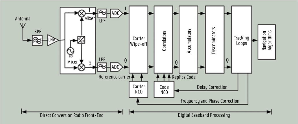
FIGURE 1: Block-diagram of a GNSS direct-conversion receiver


For the complete story, including figures, graphs, and images, please download the PDF of the article, above.

GNSS systems rely on direct sequence spread spectrum (DSSS) transmissions to achieve high receiver sensitivity. Typically, GNSS user equipment compares the signal received from a satellite with an internally generated replica of its corresponding code until the maximum correlation for a given delay is achieved. This provides an indirect measurement of the satellite-receiver range.

Read More >

By Inside GNSS

Military PNT — The Way Ahead

FIGURE 1: The three foundations of C2 and how they are “changing the game” in an electronic battlespace: spectrum (communications media), yellow; computers (digital data), green; PNT (precise position and timing), blue.

With thanks to Yogi Berra, it’s “déjà vu all over again” for the Global Positioning System, but this time with a twist.

Twenty-five years ago, the question asked by U.S. military commanders and combat personnel in the field was, “Why should I go to the trouble to use this space-based system called GPS?” Today, the question being asked is, “GPS is vital to the success of my mission; so, why are you asking me to consider using something else?”

Read More >

By Inside GNSS
1 58 59 60 61 62 66
IGM_e-news_subscribe