
Global Navigation Satellite Systems Engineering, Policy, and Design
Global Navigation Satellite Systems Engineering, Policy, and Design

First, let’s review the record of presidential leadership in GPS.
In 1983, following the shooting down of an errant Korean airliner over Soviet airspace, President Ronald Reagan ordered the U.S. Air Force to make GPS available for civilian use so that such navigational errors could be avoided in the future.
George H. W. Bush was commander in chief in 1991 during the first Persian Gulf when GPS helped coalition troops throw the so-called “left hook” by navigating through the desert around entrenched Iraqi troops in Kuwait.
By Inside GNSS
Budget storms have reappeared on the horizon and the fore¬cast for defense expenditures, including for the GPS program, is grim with a high probability of ugly.
By Dee Ann Divis Equation 1
Q: How does measurement differencing affect my computed position?
A: The short answer is, “That depends.”
Standalone, or undifferenced, measurements obviously produce the poorest positioning performance. However, how we proceed from this most basic data processing approach may affect the computed solution. In this article, we look at the details of why this occurs.
By Inside GNSS
Working Papers explore the technical and scientific themes that underpin GNSS programs and applications. This regular column is coordinated by Prof. Dr.-Ing. Günter Hein, head of Europe’s Galileo Operations and Evolution.
By Inside GNSS
CORS and OPUS for Engineers
Edited by Tomás Soler
PUBLISHED BY THE AMERICAN SOCIETY OF CIVIL ENGINEERS

Consumer demand for positioning information is currently being met by a plethora of wireless positioning technologies. The most popular consumer positioning technology, GNSS, is only one option along with several methods that use cellular networks to provide location, such as wireless local area networks (WLANs), wireless personal area networks (WPANs), radio frequency identification (RFID) tags, and ultrawideband (UWB) communications.
By Inside GNSS
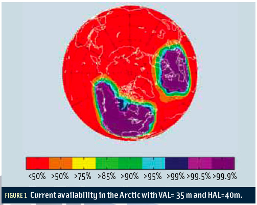 FIGURE 1: Current availability in the Arctic with VAL=35 m and HAL=40m.
The Arctic houses an estimated 90 billion barrels of undiscovered, technically recoverable oil and 44 billion barrels of natural gas liquids according to the U.S. Geological Survey. These potential energy reserves represent 13 percent of the untapped oil in the world.
By Inside GNSS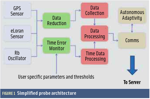 FIGURE 1: Simplified probe architecture
GNSS vulnerability is rightly one of the most talked about topics of 2011.
By Inside GNSS
FIGURE 1: GPS III On OrbitIn May 2008, Lockheed Martin Space Systems Company received a contract from the U.S. Air Force to develop a new, third generation of GPS satellites. The GPS III space vehicle (SV) has been designed (Figure 1, see inset photo, above right) and is now being built to bring new future capabilities to both military and civil positioning, navigation, and timing (PNT) users throughout the globe.
By Inside GNSS
 One of 12 magnetograms recorded at Greenwich Observatory during the Great Geomagnetic Storm of 1859
 1996 soccer game in the Midwest, (Rick Dikeman image)
 Nouméa ground station after the flood
 A pencil and a coffee cup show the size of NASA’s teeny tiny PhoneSat
 Bonus Hotspot: Naro Tartaruga AUV
 Pacific lamprey spawning (photo by Jeremy Monroe, Fresh Waters Illustrated)
 “Return of the Bucentaurn to the Molo on Ascension Day”, by (Giovanni Antonio Canal) Canaletto
 The U.S. Naval Observatory Alternate Master Clock at 2nd Space Operations Squadron, Schriever AFB in Colorado. This photo was taken in January, 2006 during the addition of a leap second. The USNO master clocks control GPS timing. They are accurate to within one second every 20 million years (Satellites are so picky! Humans, on the other hand, just want to know if we’re too late for lunch) USAF photo by A1C Jason Ridder.
  Detail of Compass/ BeiDou2 system diagram
 Hotspot 6: Beluga A300 600ST

1. AQUARIUS
Buenos Aires, Argentina and Vandenberg AFB, California, USA
