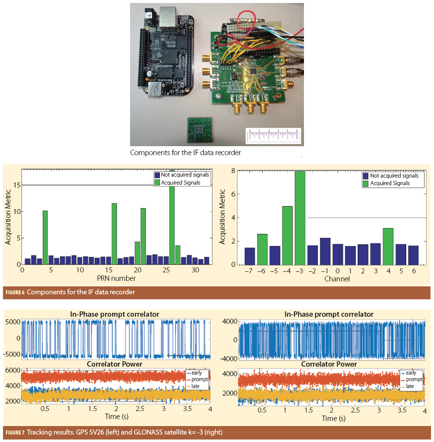
Are there low-cost and low-weight options for GNSS IF storage?

Q: Are there low-cost and low-weight options for GNSS IF storage?
By Inside GNSS
Q: Are there low-cost and low-weight options for GNSS IF storage?
By Inside GNSS The Miller family: Casey, Colleen, Mikel, Krista, Lauren, Trevor, and Megan.
It has been a long journey to success for Mikel M. Miller, the U.S. Air Force’s lead scientist for positioning, navigation, and timing (PNT) science and technology development.
By Inside GNSSA cooperative network of government labs, funded by a hopeful broadband company, is now testing GPS receivers in a surprise program that will draw key federal agencies directly into an argument over GPS interference standards.
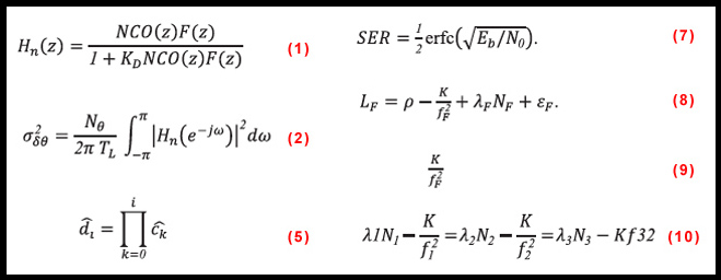
By Dee Ann Divis Equations
The Galileo E6 signal is centered at 1278.75 MHz, and comprises three signals: an authorized signal (E6A, the publicly regulated service, PRS plus two civilian signals), a data component (E6B), and a pilot component (E6C). Both E6B and C are modulated using binary-phase shift keying (BPSK) code division multiple access (CDMA) memory codes, having lengths of 5,115 chips and chipping rates of 5.115 Mcps.
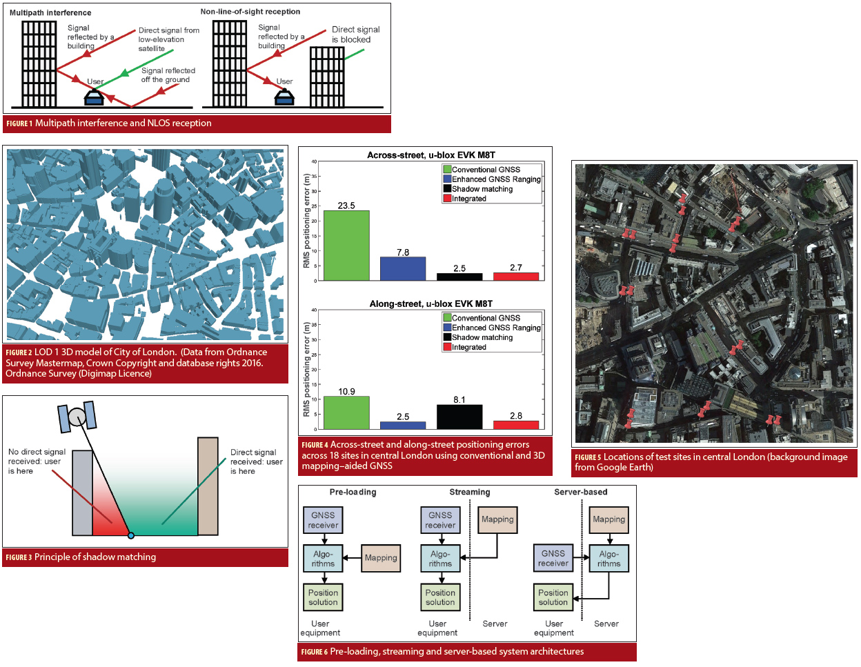
By Inside GNSS Figures 1-6
Real-time position accuracy, achievable in dense urban areas using low-cost equipment, is currently limited to tens of meters. If this could be improved to five meters or better, a host of potential applications would benefit. These include situation awareness of emergency, security and military personnel and vehicles; emergency caller location, mobile mapping, tracking vulnerable people and valuable assets, intelligent mobility, location-based services and charging, augmented reality; and enforcement of curfews, restraining orders and other court orders.
By Inside GNSSReasonable Expectations of Privacy and a discussion of privacy in the United States typically begins with the Fourth Amendment of the U.S. Constitution, which provides that “[t]he right of the people to be secure in their persons, houses, papers, and effects, against unreasonable searches and seizures, shall not be violated.” In U.S. v Katz, the U.S. Supreme Court found that this Fourth Amendment protection created an individual’s constitutional right to privacy.
By Ingo Baumann Jade Morton’s favorite equation
Return to main article: "Jade Morton: The Long and Scintillating Road"
COMPASS POINTS
Engineering specialties
GNSS receiver data collection systems, GNSS receiver signal processing, GNSS for remote sensing of atmosphere and ionosphere, new navigation applications and technologies.
GNSS event that most signified to you that GNSS had ‘arrived’
By Inside GNSSThe Air Force is defending the new GPS ground system, taking a stand against naysayers in Congress and declaring through its actions an intent to stick with the Next Generation Operational Control System program (OCX) — at least for now.
The most public of these actions occurred June 30 when Secretary of the Air Force Deborah Lee James announced OCX would surpass by at least 25 percent the program’s estimated cost. She declared a critical Nunn-McCurdy breach, putting the program on a path to automatic cancellation.
By Dee Ann Divis Jade Morton, in the front row at the right, with her sisters and grandmother
>>Jade Morton’s Compass Points
Yu — or Jade, in English — Morton is an electrical engineer, a professor at Colorado State University (bound for the University of Colorado Boulder in 2017), and a shining star in the world of GNSS. She left work for eight years to be a full-time mother, then returned to a university professorship and high-level research, where she has been recognized for her work on ionospheric effects on global navigation satellite systems.
By Inside GNSS
Four global navigation satellite systems are scheduled to be fully operational orbiting Earth in the coming years: the NAVSTAR Global Positioning System (GPS) from the United States, the GLObal NAvigation Satellite System (GLONASS) from Russia, the Compass/BeiDou-2 System (BDS) from China, and Galileo from Europe. A considerably high number of signals, coming from the satellites of those constellations, will share the radio electric spectrum.
By Inside GNSSJapan’s regional and augmentation positioning system, the Quasi-Zenith Satellite System (QZSS), is a project yet to be developed. While it will become a constellation of seven satellites covering the western Pacific area, only “Michibiki,” the first satellite launched in 2010 for technological validation , is now in orbit.
By Ingo Baumann
Q: How does one compute the noise power to simulate real and complex GNSS signals?
By Inside GNSS