Magazine Department

Integer Aperture Estimation

For the complete story, including figures, graphs, and images, please download the PDF of the article, above.

Integer carrier-phase ambiguity resolution is the key to fast and high-precision GNSS positioning and navigation. It is the process of resolving the unknown cycle ambiguities of the carrier-phase data as integers. Once this has been done successfully, the very precise carrier-phase data will act as pseudorange data, thus making very precise positioning and navigation possible.

Read More >

By Inside GNSS

Coherent Integration Time Limits

Equation: signal variance for a “ring of scatterers” model

Indoor GNSS propagation environments are characterized by multiple reflected signal paths (multipath) terminating at the receiver. Consequently, the received signal’s amplitude, phase, and perceived angle of arrival attributes vary randomly as the receiver moves. This has created significant interest among receiver designers and manufacturers to develop powerful processing for GNSS handsets such that these can operate effectively in indoor faded environments.

Read More >

By Inside GNSS

The Civilian Battlefield

Figures 1 & 2

For the complete story, including figures, graphs, and images, please download the PDF of the article, above.

Growing dependence on GNSS for positioning, navigation, and timing (PNT) has raised a parallel concern about the potential risks of signal interference. The popular press has recently highlighted accounts of car thieves using GPS jammers, solar flares pumping out L-band radiation, and faulty television sets causing havoc to GPS receivers across an entire harbor.

Read More >

By Inside GNSS
[uam_ad id="183541"]

GNSS Inside Mobile Phones

Figure 1 & Table 1

For the complete story, including figures, graphs, and images, please download the PDF of the article, above.

Recent years have seen GPS receivers built in as a standard feature in many consumer products. A growing number of mobile phones, personal navigation devices, netbooks and tablets are equipped with GPS receiver chips and navigation software that enable consumers to navigate from A to B or find their nearest coffee shop. According to Berg Insight, annual shipments of GPS-equipped mobile phones are estimated to reach 960 million devices in 2014.

Read More >

By Inside GNSS
January 21, 2011

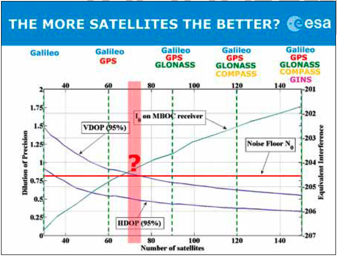
Your Signal Is My Noise

Most people probably don’t associate engineers and linguistic virtuosity.

The attitude is unfair, of course, as with so many stereotypes.

And also untrue.

For example, as the number of existing or planned GNSS systems grew during the past few years, the expression “Your signal is my noise” has recurred in the engineering community with increasing frequency.

I consider that an elegant, if ominous, turn of phrase. A simple declarative sentence, pithy, with an ironic edge, yet almost lyrical.

Read More >

By Inside GNSS

Spectrum-Compact Signals

FIGURE 1 (a, b, c) & FIGURE 2

For the complete story, including figures, graphs, and images, please download the PDF of the article, above.

In the early stages of developing space-based radionavigation, the spectrum compactness of ranging signals was not proclaimed among the material priorities. Conventional bi-phase shift keying (BPSK) modulations, although they consume a rather large amount of spectrum, were adopted as the basis for both GPS and GLONASS signals.

Read More >

By Inside GNSS
[uam_ad id="183541"]
January 9, 2011

Differences between Signal Acquisition and Tracking

Q: Why is acquisition of GNSS signals generally more difficult than tracking and what are the limiting factors?

A: A fairly good analogy of the difference between GNSS signal acquisition and tracking can be found in the rescue of victims of a sunken ship whose location is not accurately known. The first stage of the rescue attempt typically involves an aircraft flying a search pattern, which hopefully encompasses the location where the ship went down.

Read More >

By Inside GNSS

Wavelets and Notch Filtering

FIGURE 1: Touching wavelet spectra

For the complete story, including figures, graphs, and images, please download the PDF of the article, above.

The use of GNSS for safety critical applications is gaining interest, particularly amongst aviation users, who probably have the most demanding requirements. The GNSS frequency band containing the Galileo E5 and GPS L5 signals is designated as an aeronautical radio navigation service (ARNS) band, which enjoys legal protection from other services not allocated to this frequency on a primary basis.

Read More >

By Inside GNSS

A Model-Based Approach

For the complete story, including figures, graphs, and images, please download the PDF of the article, above.

Galileo receiver designers require formal interface specifications for the Galileo signal-in-space (SIS) in order to write unambiguous and accurate specifications for Galileo receivers. To compute their positions, Galileo receivers must be able to retrieve timing and orbital information from the data stream conveyed in Galileo analog signals.

Read More >

By Inside GNSS

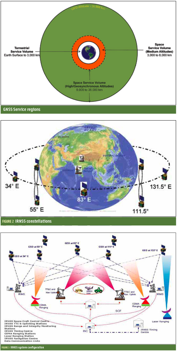
Indian Regional Navigation Satellite System

FIGURES 1, 2 & 3

For the complete story, including figures, graphs, and images, please download the PDF of the article, above.

In satellite navigation, a GNSS receiver must account for several sources of error such as relativistic effects, atmospheric propagation delay, offset of satellite clocks from system time and satellite ephemeris. In order to accurately compute user position, velocity, and time (PVT), these errors need to be predicted/estimated precisely.

Read More >

By Inside GNSS
January 4, 2011

GPS Programs Push Ahead

The GPS program continues progress on several fronts — in space and on the ground.

During fall 2010, the U.S. Air Force and the Raytheon Company team developing the GPS Advanced Control Segment (OCX) successfully carried out an integrated baseline review (IBR) for the next-generation system on schedule.

When completed in 2015 under the current schedule, GPS OCX will deliver control segment enhancements designed to provide secure, accurate and reliable navigation and timing information to military, commercial and civil users.

Read More >

By Inside GNSS
December 2, 2010

Measuring GNSS Signal Strength

Q: What is the difference between SNR and C/N0?

A: GPS receivers built for various applications, such as handhelds, automobiles, mobile phones, and avionics, all have a method for indicating the signal strength of the different satellites they are tracking. Some receivers display the signal strength in the form of vertical bars, some in terms of normalized signal strength, and others in terms of carrier-to-noise density (C/N0) or signal-to-noise ratio (SNR).

Read More >

By Inside GNSS
IGM_e-news_subscribe