201101 January/February 2011 Archives - Inside GNSS - Global Navigation Satellite Systems Engineering, Policy, and Design

201101 January/February 2011

January 21, 2011

Your Signal Is My Noise

Most people probably don’t associate engineers and linguistic virtuosity.

The attitude is unfair, of course, as with so many stereotypes.

And also untrue.

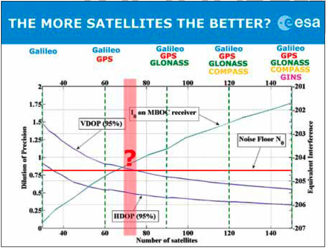
For example, as the number of existing or planned GNSS systems grew during the past few years, the expression “Your signal is my noise” has recurred in the engineering community with increasing frequency.

I consider that an elegant, if ominous, turn of phrase. A simple declarative sentence, pithy, with an ironic edge, yet almost lyrical.

Read More >

By Inside GNSS

Spectrum-Compact Signals

FIGURE 1 (a, b, c) & FIGURE 2

For the complete story, including figures, graphs, and images, please download the PDF of the article, above.

In the early stages of developing space-based radionavigation, the spectrum compactness of ranging signals was not proclaimed among the material priorities. Conventional bi-phase shift keying (BPSK) modulations, although they consume a rather large amount of spectrum, were adopted as the basis for both GPS and GLONASS signals.

Read More >

By Inside GNSS
January 18, 2011

Galileo Mid-Term Review Foresees €1.9 Billion in Additional Costs

Antonio Tajani, EC Vice-President. EC photo

A European Commission (EC) communication sent to the European Parliament and European Council today (January 18, 2011) estimates that completing a fully operational capability (FOC), 30-satellite Galileo system and the European Geostationary Navigation Overlay Service (EGNOS) will cost an additional €1.9 billion above the €3.4 billion already allocated.

Read More >

By Inside GNSS
[uam_ad id="183541"]
January 9, 2011

Differences between Signal Acquisition and Tracking

Q: Why is acquisition of GNSS signals generally more difficult than tracking and what are the limiting factors?

A: A fairly good analogy of the difference between GNSS signal acquisition and tracking can be found in the rescue of victims of a sunken ship whose location is not accurately known. The first stage of the rescue attempt typically involves an aircraft flying a search pattern, which hopefully encompasses the location where the ship went down.

Read More >

By Inside GNSS

Wavelets and Notch Filtering

FIGURE 1: Touching wavelet spectra

For the complete story, including figures, graphs, and images, please download the PDF of the article, above.

The use of GNSS for safety critical applications is gaining interest, particularly amongst aviation users, who probably have the most demanding requirements. The GNSS frequency band containing the Galileo E5 and GPS L5 signals is designated as an aeronautical radio navigation service (ARNS) band, which enjoys legal protection from other services not allocated to this frequency on a primary basis.

Read More >

By Inside GNSS

A Model-Based Approach

For the complete story, including figures, graphs, and images, please download the PDF of the article, above.

Galileo receiver designers require formal interface specifications for the Galileo signal-in-space (SIS) in order to write unambiguous and accurate specifications for Galileo receivers. To compute their positions, Galileo receivers must be able to retrieve timing and orbital information from the data stream conveyed in Galileo analog signals.

Read More >

By Inside GNSS
[uam_ad id="183541"]

Indian Regional Navigation Satellite System

FIGURES 1, 2 & 3

For the complete story, including figures, graphs, and images, please download the PDF of the article, above.

In satellite navigation, a GNSS receiver must account for several sources of error such as relativistic effects, atmospheric propagation delay, offset of satellite clocks from system time and satellite ephemeris. In order to accurately compute user position, velocity, and time (PVT), these errors need to be predicted/estimated precisely.

Read More >

By Inside GNSS
December 30, 2010

GPS Directorate Completes Annual AGER Review

Col. Bernard Gruber

The GPS Directorate completed its second Annual GPS Enterprise Review (AGER) on December 17, concluding that the program has achieved major milestones in developing and deploying modernized GPS capabilities.

Col. Bernard Gruber, GPS program director at the Space and Missile Systems Center, Los Angeles Air Force Base, led his team through a Defense Acquisition Board (DAB) review chaired by Frank Kendall, deputy undersecretary of defense for acquisition, technology and logistics, and attended by other senior Department of Defense (DoD) officials.

Read More >

By Inside GNSS
IGM_e-news_subscribe